Inserts a dataset into the current SIS Workspace Definition (SWD), which will fetch data from non-file data source.
See OGC WMS for a full description.
| Visual Basic |
|---|
Public Function CreateDataSourceOverlay( _ ByVal pos As Integer, _ ByVal clsDataSource As String, _ ByVal parameters As String _ ) As Integer |
Notes:
Mandatory parameters will be coloured RED.
Examples using params = {} are based on Python.
clsDataSource = "AOracleSpatialCursorDts"
| Parameter | Type | Comments |
| service | String | |
| user | String | |
| password | String | |
| table | String | |
| geometrycolumn | String | |
| Plaintext | Boolean | Set to "True" if passing a non-encrypted password when the server is expecting encryption. An encrypted password is assumed by default, in this case do not specify the Plaintext parameter. |
| filter | String | |
| cache | Boolean | |
| anglecolumn | String | |
| fcodecolumn | String | |
| uricolumn | String |
Example
In VB:
Dim params As String
Params = "user=MYLOGIN,password=MYPWD,service=MYDBSVR,table=MYTABLE,cache=true"
GisCreateDataSourceOverlay (1,"AOracleSpatialCursorDts ",params)
clsDataSource = "APostGisCursorDts"
| Parameter | Type | Comments |
| host | String | |
| port | String | |
| database | String | |
| user | String | |
| password | String | |
| table | String | |
| geometrycolumn | String | |
| Plaintext | Boolean | Set to "True" if passing a non-encrypted password when the server is expecting encryption. An encrypted password is assumed by default, in this case do not specify the Plaintext parameter. |
| filter | String | |
| cache | Boolean | |
| anglecolumn | String | |
| fcodecolumn | String | |
| uricolumn | String |
clsDataSource = "PostGISRasterDataset"
Parameter Type Comments host String port String database String user String password String schema String Typically "public" rastertable String Equivalent to "table" in PostGIS rastercolumn String Equivalent to "geometrycolumn" in PostGIS Plaintext Boolean Set to "True" if passing a non-encrypted password when the server is expecting encryption.
An encrypted password is assumed by default, in this case do not specify the Plaintext parameter.connectiontype String "dynamic"
"import"
"local"showerrors Boolean
clsDataSource = "TileMapServiceDataset"
params = {}
params['url'] = 'http://server:port/osgeoservice/tms/1.0.0/image-format/projection/name_of_layer_being_served.xml'sis.CreateDataSourceOverlay(0, 'TileMapServiceDataset', json.dumps(params))
clsDataSource = "OpenStreetMapDatasetEx"
Parameter Type Comments Nodes Boolean Relations Boolean Ways Boolean SkipTags Boolean Note: It is not mandatory to include all of the above parameters, but at least one must be used
If adding parameters in old style parameter string, also use:
Parameter Type Comments bbox String "minx,miny,maxx,maxy" If adding parameters in (recommended) JSON string style, also use:
Parameter Type Comments Left Double Equivalent minx Bottom Double Equivalent miny Right Double Equivalent maxx Top Double Equivalent maxy
String format:
sis.CreateDataSourceOverlay(0, "OpenStreetMapDatasetEx", "bbox=\" 11.54,48.14,11.543,48.145 \",Nodes=True")
JSON format:
p = { "Left":11.54,"Bottom":48.14,"Right":11.543,"Top":48.145,"Nodes": True, "Ways" :True, "Relations": True }sis.CreateDataSourceOverlay(0, "OpenStreetMapDatasetEx", json.dumps(p))
clsDataSource = "OpenStreetMapTileDataset"
Parameter Type Comments URL String URL to the Tile Server MaxLevel Integer Max. zoom level
Example
params = {}params["URL"] = "http://tile.openstreetmap.org/<z>/<x>/<revy>.png"
params["MaxLevel"] = 17
sis.CreateDataSourceOverlay(0,"OpenStreetMapTileDataset", json.dumps(params))
clsDataSource = "AOsDnfCursorDts"
Parameter Type Comments Connection String Connection needs to be prefixed with ODB or MDB depending on source. See example below. Table String Table is always "MASTERMAP" points String "true" includes point geometry types.
"false" doesn't include point geometry types.lines String "true" includes linestrings geometry types.
"false" doesn't include linestrings geometry types.areas String "true" includes polygon geometry types.
"false" doesn't include polygon geometry types.
Example
Sis.CreateDataSourceOverlay(0,"AOsDnfCursorDts", "Connection=""ODB:c:\\Brighton.odb"", Table=""MASTERMAP"", points=""true"", lines=""true"", areas=""true""")
Notes: In VB.net use double dashes in path names and double quotes for embedded parameter string values.
clsDataSource = "FileGeoDatabaseDataset"
Parameter Type Comments folder String Path to GeoDatabase File table String Optional choice of table
clsDataSource = "GeoJSONFeaturesDatasetEx"
params = {}
params["cache"] = True
params["url"] = "https://url_to_some/geojson_data/geo_data_file.geojson"
sis.CreateDataSourceOverlay(0, "GeoJSONFeaturesDatasetEx", json.dumps(params))
clsDataSource = "GeoRSSDataset"
| Parameter | Type | Comments |
| url | String | URL of GeoRSS to open |
| RefreshInterval | Integer | Number of minutes |
clsDataSource = "TopoJSONFeaturesDatasetEx"
params = {}
params["cache"] = True
params["url"] = "https://url_to_some/topo_json_data/topo_data_file.json"
sis.CreateDataSourceOverlay(0, "TopoJSONFeaturesDatasetEx", json.dumps(params))
clsDataSource = "ECWDataSource"
Parameter Type Comments url String the ECWP URL
clsDataSource = "ArcIMSDataSource"
Parameter Type Comments url String the ArcIMS URL service String the ArcIMS service
clsDataSource = "EXIFDataset"
Parameter Type Comments folder String path to folder recurse String "true" "false"
clsDataSource = "GDALDataSource"
clsDataSource = "*_GDALDataset"
Parameter Type Comments filename String path to file model String Colour Model of raster: "monochrome"
"grayscale"
"palette"
"rgb"
"hls"
"cmy"
"cmyk"
"grid"
"rgba"
stretch String Enable stretch: "true"
"false"
method String Stretch method: "linear"
"squareroot"
"logarithmic"
"exponential"
"equalization"
"negative"
trim Integer Stretch Tail Trim (%): Number in the range 1 to 5, inclusive
band1 Integer Number where n can range from 0 to the number of bands -1, inclusive band2 Integer band3 Integer band4 Integer Notes on band selection:
Band selection always starts with `band1`, which then may be followed by `band2`, which in turn may be followed by `band3`, which in turn may be followed by `band4`.
There must be no 'gaps' in the band parameters.
For example, the following are valid band selection parameters:
band1=
band1=,band2=
band1=,band2=,band3=
band1=,band2=,band3=,band4=Whereas, the following are invalid sequences:
band2=
band2=,band1=
band3=,band2=
band1=,band3=,band2=The band indices are not relevant in the above examples and have therefore not been shown.
colour String red:green:blue e.g. 255:0:0 for red algorithm String Set the resampling method:
"none"
"nearestneighbour"
"bilinear"
"cubic"
"cubicspline"
"lanczos"
clsDataSource = "GeoDatabaseDataset"
tables
clsDataSource = "AGMLImporterEx"
Parameter Type Comments url String path to GML file DefaultItemStatus Integer 0 invisible 1 visible
2 hittable
Validate Boolean PreloadSchema Integer Where n is the schema reference: 20102 is GML 2.1.2
30101 is GML 3.1.1
30201 is GML 3.2.1
-1 is Custom Schema (see below parameter)
SwapAxes Boolean By default, coordinates are expressed using the axis order defined in the CRS True = force to always swap axes
False = force to never swap axes
CustomSchema String The path to the XML grammar file to be used. Note: PreloadSchema parameter must be -1
Examples
For C#, either of the two forms:
sis.CreateDataSourceOverlay(0, "AGMLImporterEx", "url=\"file://localhost/D:\\\\data\\\\test.gml\",DefaultItemstatus=2,validate=true,PreloadSchema=30101");
sis.CreateDataSourceOverlay(0, "AGMLImporterEx", @"url=""file://localhost/D:\\data\\test.gml"",DefaultItemstatus=2,validate=true,PreloadSchema=30101");
For VB:
sis.CreateDataSourceOverlay(0, "AGMLImporterEx","url=""file://localhost/D:\\data\\test.gml"",DefaultItemstatus=2,validate=true,PreloadSchema=30101")
For Python, either of the two forms:
sis.CreateDataSourceOverlay(0, "AGMLImporterEx","url=\"file://localhost/D:\\\\data\\\\test.gml\",DefaultItemstatus=2,validate=true,PreloadSchema=30101")
sis.CreateDataSourceOverlay(0, "AGMLImporterEx","url=\"file://localhost/D:/data/test.gml\",DefaultItemstatus=2,validate=true,PreloadSchema=30101")
or serialising parameters from dictionary object to JSON string, then no extra escaping of backslashes \\\\ or double quotes \" is required:
params = {
"DefaultItemstatus":2,
"validate":1
"PreloadSchema":30101,
"url":"file://localhost/D:\\data\\test.gml"
}
sis.CreateDataSourceOverlay(0, "AGMLImporterEx", json.dumps(params))
Note: For API methods that take a list of string as a single parameter, Cadcorp recommend passing the list as a JSON string.
clsDataSource = "DNCDataSource"
clsDataSource = "DNCDataSourceEx"
Parameter Type Comments directory String Path to folder containing NGA Digital Nautical Chart LHT file. coverage String Name of coverage to add (as defined in the folder name) lon Integer Centre longitude (degrees) lat Integer Centre latitude (degrees) width Integer Extents (degrees), Width (E/W) height Integer Extents (degrees), Height (N/S)
The clsDataSource, "DNCDataSource", allows you to add an individual coverage. To load multiple coverages at once, use clsDataSource = "DNCDataSourceEx". It requires the same parameters as above as well as:
| Parameter | Type | Comments |
| coverages | String | This is used instead of "coverage" listed above |
The clsDataSource, "ADcwDts", uses slightly different parameter names, as follows:
| Parameter | Type | Comments |
| folder | String | Path to folder containing LHT file |
| coverage | String | Name of coverage to add (as defined in the folder name) |
| longitude | Integer | Centre longitude (degrees) |
| latitude | Integer | Centre latitude (degrees) |
| radius | Integer | Extents (degrees) as a radius |
clsDataSource = "OracleGeoRasterDataset"
| Parameter | Type | Comments |
| service | String | |
| user | String | |
| password | String | |
| connectiontype | String |
"dynamic"
"import" "local" |
| georastertable | String | |
| georastercolumn | String | |
| rasterid | String | |
| rdttable | String | The Raster Data Table |
| Plaintext | Boolean | Set to "True" if passing a non-encrypted password when the server is expecting encryption. An encrypted password is assumed by default, in this case do not specify the Plaintext parameter. |
| forcegrid | Boolean |
This is optional dependent on type of data.
To add an Oracle GeoRaster overlay in dynamic mode, you must add the forcegrid:False parameter. |
| showerrors | Boolean |
Example:
VB.net:
Dim connection As String
connection = "OCI:User=qa;Password=spatial;Service=\""//10.0.0.22:1521/orcl.cadcorp.net\"""
Dim params As String
params = "{"
params += """connection"":""" + connection + """"
params += ","
params += """connectiontype"":""import"""
params += ","
params += """georastertable"":""SIS_GEORASTER_EXPORT"""
params += ","
params += """georastercolumn"":""GEORASTER"""
params += ","
params += """showerrors"":true"
params += ","
params += """rdttable"":""SIS_RDT"""
params += ","
params += """rasterid"":""12"""
params += ","
params += """owner"":""qa"""
params += "}"
sis.CreateDataSourceOverlay(0, "OracleGeoRasterDataset", params)
clsDataSource = "OracleNetworkDataSource"
Parameter Type Comments service String user String password String Plaintext Boolean Set to "True" if passing a non-encrypted password when the server is expecting encryption.
An encrypted password is assumed by default, in this case do not specify the Plaintext parameter.showerrors Boolean network String
Example:
Sis.CreateDataSourceOverlay(0, "OracleNetworkDataSource", "connection=""OCI:service=orac10g2;user=spatial;password=spatial"",showerrors=true,network=TEST11"
clsDataSource = "OsDnfAddressDataset"
clsDataSource = "OsDnfITNDataset"
Parameter Type Comments folder String Path to folder containing the dataset recurse String "true" "false"
clsDataSource = "OsDnfImageryDataset"
clsDataSource = "OsDnfIndexDataset"
Parameter Type Comments folder String Path to folder containing the dataset recurse String "true" "false"
label String "true" "false"
gatewaylimit Integer
clsDataSource = "OSMeridian2Dataset"
Parameter Type Comments folder String Path to folder containing the dataset
clsDataSource = "ACityGMLImporterEx"
clsDataSource = "AOgcOwsContextDatasetEx"
Parameter Type Comments url String showerrors Boolean cascadetowmc Boolean Controls whether to check WMSContext instead of an OWSContext document
clsDataSource = "AOgcWmsContextDatasetEx"
Parameter Type Comments url String showerrors Boolean
clsDataSource = "KMLDatasetEx"
Parameter Type Comments url String URL to KML data
clsDataSource = "RasterIndexDataset"
Parameter Type Comments directory String path to folder containing rasters scale Integer gatewaylimit Integer recurse Boolean
clsDataSource = "SDEDataSource"
Parameter Type Comments connection String "username/password@service" extents String "lox, loy, hix, hiy" layerid dynamic String "true" "false"
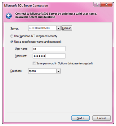
The parameter string for a SQL Server connection must be a valid JSON string which contains following parameter:
connection: A connection string which contains the provider (SQLOLEDB.1), data source (server), catalog, password, and user id.
The following “connection” string is valid for a Microsoft SQL Server Connection which is represented in the Add Database Overlay dialog.
"connection":
"Provider=SQLOLEDB.1;
Password=spatial;
Persist Security Info=True;
User ID=username;
Initial Catalog=spatial;
Data Source=servername;"
datasource: The Table/Datasource (_dataSource$).
geometrycolumn: The geometry field from the SQL Server table (_geometryColumn$).
wkt: A well known text which describes the CRS coordinate reference system of the new data source overlay.
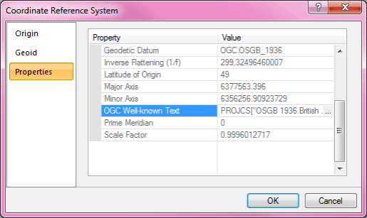
The following “wkt” string is valid for a new data source overlay which uses the British National Grid (OGC.OSGB_1936) as CRS. Other CRS WKT need to be built as JSON from the OGC Well-known Text in the Cadcorp SIS Named Object Library.
"wkt":
"PROJCS[\"OSGB 1936.British National Grid\",
GEOGCS[\"Latitude/Longitude.OGC.OSGB_1936\",
DATUM[\"OSGB_1936\",
SPHEROID[\"Airy 1830\",6377563.396,299.32496460007]],
PRIMEM[\"Greenwich\",0],
UNIT[\"degrees\",0.0174532925199433]],
PROJECTION[\"Transverse_Mercator\"],
PARAMETER[\"Central_Meridian\",-2],
PARAMETER[\"False_Easting\",400000],
PARAMETER[\"False_Northing\",-100000],
PARAMETER[\"Latitude_of_Origin\",49],
PARAMETER[\"Scale_Factor\",0.9996012717],
UNIT[\"m\",1]]"
cache: boolean
readonly: boolean
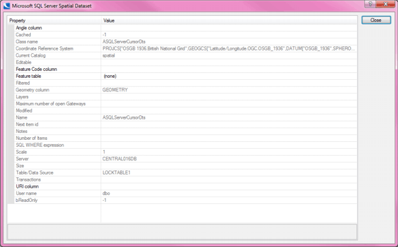
Below is a complete example of a JSON parameter string for a SQL Server (ASQLServerCursorDts) datasource connection:
{
"connection":
"Provider=SQLOLEDB.1;
Password=spatial;
Persist Security Info=True;
User ID=username;
Initial Catalog=initialcat;
Data Source=datasource;",
"datasource": "LOCKTABLE1",
"geometrycolumn": "GEOMETRY",
"wkt":
"PROJCS[\"OSGB 1936.British National Grid\",
GEOGCS[\"Latitude/Longitude.OGC.OSGB_1936\",
DATUM[\"OSGB_1936\",
SPHEROID[\"Airy 1830\",6377563.396,299.32496460007]],
PRIMEM[\"Greenwich\",0],
UNIT[\"degrees\",0.0174532925199433]],
PROJECTION[\"Transverse_Mercator\"],
PARAMETER[\"Central_Meridian\",-2],
PARAMETER[\"False_Easting\",400000],
PARAMETER[\"False_Northing\",-100000],
PARAMETER[\"Latitude_of_Origin\",49],
PARAMETER[\"Scale_Factor\",0.9996012717],
UNIT[\"m\",1]]",
"cache": true,
"filter":"FEATURE_ID<10"
"readonly": true
}
Note: "cache" and "filter" are described in the Microsoft SQL Server Spatial (Dataset) topic.
It is strongly recommended to validate the JSON string (for example with JSONLint).If a SQL Server connection has been built in the SIS desktop then all parameters can be gathered from the dataset properties.
clsDataSource = "VpfDts"
clsDataSource = "VpfDtsEx"
Parameter Type Comments directory String Path to the folder containing LHT file coverage String Name of coverage to add (as defined in the folder name) lat Integer Centre latitude (degrees) lon Integer Centre longitude (degrees) width Integer Extents (degrees), Width (E/W) height Integer Extents (degrees), Height (N/S)
The clsDataSource, "VpfDts", allows you to add an individual coverage. To load multiple coverages at once, use clsDataSource = "VpfDtsEx". It requires the same parameters as above as well as:
Parameter Type Comments coverages String This is used instead of "coverage" listed above
clsDataSource = "WorldWindDataset"
Parameter Type Comments name String Name of layer to add. names String Used to add multiple layers at once. Use instead of "name" LayerSplit String Define how multiple layers will split. Not required when adding single layer:
"none"
"layers"
"overlays"
clsDataSource = "WCSDataSource"
Parameter Type Comments url String coverage String showerrors String "true" "false"
user String password String connection String "dynamic" "import"
"local"
forcegrid String "true" "false"
temporal String "true" "false"
defaultItemStatus Integer 0 invisible 1 visible
2 hittable
clsDataSource = "WFSDataSource"
Parameter Type Comments getfeaturesuri String describefeaturesuri String describefeaturetypepostdata String postdata String overlayname String requestmethod String "post" "get"
validate Boolean showerrors Boolean username String password String defaultItemStatus Integer 0 invisible 1 visible
2 hittable
See OGC WFS topic for a full description.
Example:
Dim params,strURL As String
strURL = "http://www.cadcorpdev.co.uk/wfs/SisISAPI.dll?request=GETFEATURE&;version=1.0.0&;server=WFS&;typename=EDINBURGH---6&;propertyname=EDINBURGH---6.GML_Geometry,EDINBURGH---6.Status"
params = "Getfeaturesuri=""" &; strURL &; """,validate=true"
GisCreateDataSourceOverlay (0, " WFSDataSource", params)
| Parameter | Type | Comments |
| url | String | |
| showerrors | Boolean | |
| multi | String |
"true"
"false" |
| defaultItemStatus | Integer |
0 invisible
1 visible 2 hittable |
| dynamic | Boolean | |
| tiles | String | |
| user | String | |
| password | String | |
| context | String |
Dim params,strURL As String
strURL="http://www.datasource.co.uk/wms/SisISAPI.dll?VERSION=1.1.0&;SERVICE=WMS&;REQUEST=GetMap&;STYLES=&;FORMAT=image/png&;SRS=EPSG:27700&;LAYERS=EDINBURGH&;BBOX=300000,650000,350000,700000&;WIDTH=1&;HEIGHT=1&;BGCOLOR=0xFFFFFF&;TRANSPARENT=TRUE&;EXCEPTIONS=application/vnd.ogc.se_xml"
params = "URL=""" &; strURL &; """,dynamic=true"
sis.CreateDataSourceOverlay (0, "AOgcWmsDataset", params)
clsDataSource = "WMTSDataset"
Parameter Type Comments URL String RequestType Integer 0 GET 1 REST
LayerId String ImageFormat String TileMatrixSetId String ShowError Boolean The parameters should be passed as a JSON string.
Available: GEO MD MM ME OD OM OV SISpy
Group:
Bing Maps, MapQuest, OS OpenSpace, Stamen
Data source classes shown in this section are available in all SIS products with UI:
ActiveX Control
Desktop SIS (MD, MM, ME), also via:
.NET GisLink API
Python in SIS:
Python GisLink API
Python API available in the Developer Control BarData sources
- BingMapsAerialTileDataset
- BingMapsAerialWithLabelsTileDataset
- BingMapsRoadTileDataset
- MapQuestOSMTileDataset
- MapQuestOpenAerialTileDataset
- OSOpenSpaceProTileDataset
- StamenTonerLiteTileDataset
- StamenTonerTileDataset
- StamenWatercolorTileDataset
These datasets do not require any parameters.
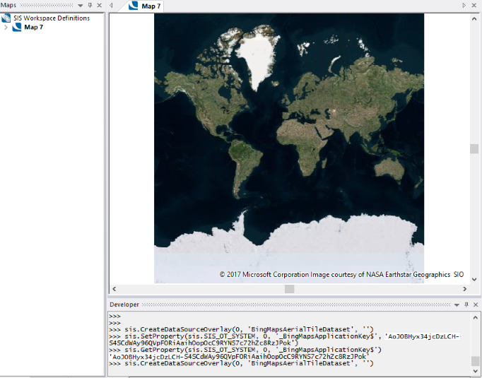
Add overlay and SIS will prompt for the Bing Maps Application Key (see the screen shot below).
1: sis.CreateDataSourceOverlay(0, 'BingMapsAerialTileDataset', '')
2: sis.CreateDataSourceOverlay(0, 'BingMapsAerialWithLabelsTileDataset', '')
3: sis.CreateDataSourceOverlay(0, 'BingMapsRoadTileDataset', '')
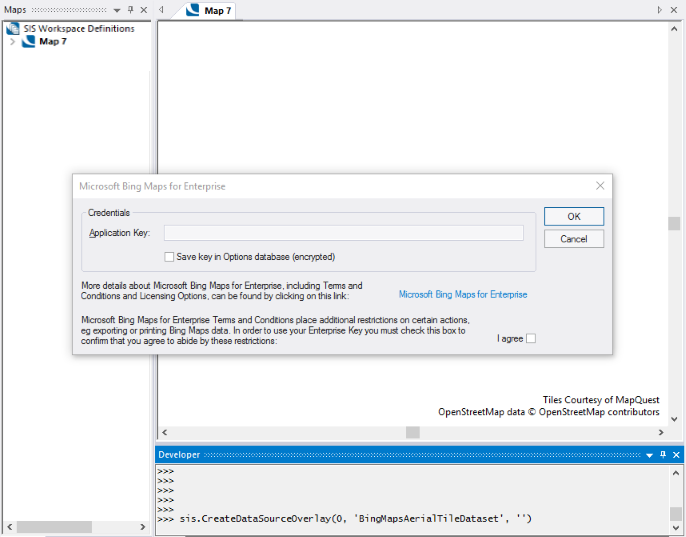
Bing Maps prompts for an Application Key
To avoid seeing the Application Key prompt, set the system variable _BingMapsApplicationKey$ prior to the API call (see the screen shot below).
1: sis.SetProperty(sis.SIS_OT_SYSTEM, 0, '_BingMapsApplicationKey$', 'AoJ0BHy...m')
2: sis.CreateDataSourceOverlay(0, 'BingMapsAerialTileDataset', '')
Note: The Application Key number shown in Line 1 above is for example only you must use your own Application Key number.
Bing Maps does not request an Application Key
Add overlay and SIS will prompt for the Application Key
1. sis.CreateDataSourceOverlay(0, 'MapQuestOSMTileDataset', '')
2. sis.CreateDataSourceOverlay(0, 'MapQuestOpenAerialTileDataset', '')
Alternatively, set the system variable _MapQuestApplicationKey$, similar to the Bing Maps alternative method shown above.
Add overlay and SIS will prompt for the Application Key (see the screen shot below).
1. sis.CreateDataSourceOverlay(0, 'OSOpenSpaceProTileDataset', '')
Alternatively, set the system variable _OSOpenSpaceProApplicationKey$, similar to the Bing Maps alternative method shown above.
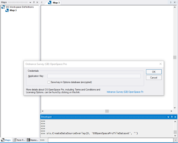
OS OpenSpace prompts for an Application Key
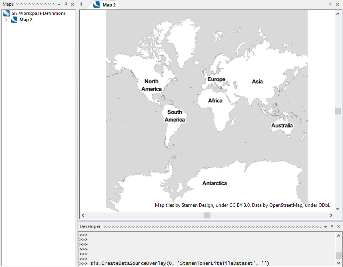
Add overlay and SIS will display the dataset (see the screen shot below).
1. sis.CreateDataSourceOverlay(0, 'StamenTonerLiteTileDataset', '')
2. sis.CreateDataSourceOverlay(0, 'StamenTonerTileDataset', '')
3. sis.CreateDataSourceOverlay(0, 'StamenWatercolorTileDataset', '')
No Application Key is required, so no system variables are provided.
Stamen does not require an Application Key
Available: GEO MD MM ME OD OM OV SISpy
Group:
Send comments on this topic.
Click to return to www.cadcorp.com
© Copyright 2000-2017 Computer Aided Development Corporation Limited (Cadcorp).