The fundamental benefit of using an RDBMS Cursor Dataset for storing spatial data are:
SIS supports the following databases for read and write capabilities using a spatial geometry object:
Oracle (Standard and Enterprise editions)
SQL Server (Standard and Enterprise editions)
PostgreSQL
SIS supports the following databases for read and write capabilities using Cadcorp Editable Geometry (a SIS controlled multi-user environment for concurrent data editing), BLOB (Binary Large OBject) or OGC SQL92 Dataset:
SIS supports the following databases for read only access for proprietary or user defined geometry fields:
SIS has various formats for storing spatial data in any of the databases listed above. Some formats are specific for a particular database, other formats can be stored in any database. Each format is made available for use in SIS as a dataset.
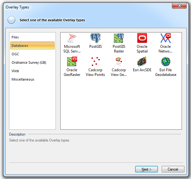
The Databases tab of the Overlay Types dialog shows the available spatial database types:
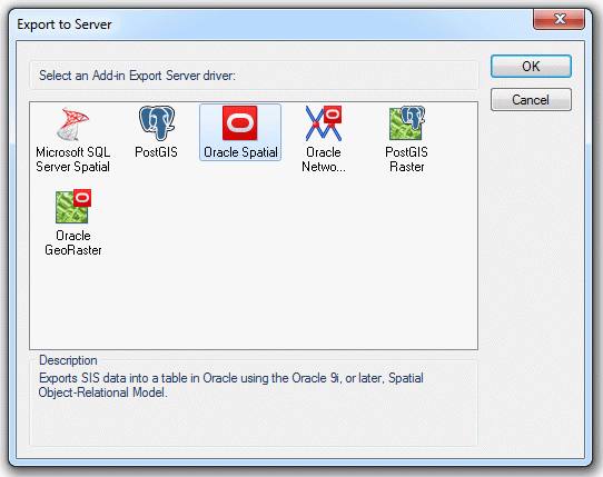
The Export to Server dialog shows the spatial formats that allow spatial data to be exported to databases:
The choice of dataset used to read data from and export data to a database will be influenced by the following factors:
Database
The type of database used by the organisation. For example if SQL Server Spatial is installed then users should use the Microsoft SQL Server Spatial dataset to read or export data to SQL Server.
It is usually cost effective for an organisation to continue to use the corporate database for all their storage requirements. For example if the organisation has a corporate policy to use SQL Server then it would be expedient to continue using SQL Server for their spatial data. This is due to the fact that the organisation has existing knowledge of the database, also additional licences will not be required if the organisation has a corporate licence for the database.
Cadcorp recommend that a new installation of the database is made on a dedicated server as processing spatial data can be CPU and disk I/O intensive.
If there is no corporate database then users should test each database to determine which is suitable for their requirements. Oracle and SQL Server can be installed using temporary trial licences. Oracle Express edition and SQL Server Express are free cut down database versions but come with spatial capabilities.
PostgreSQL is freeware.
Type of data
Users who have a requirement to store topology will be restricted to using the Editable Geometry dataset. This dataset allows data to be stored in either Oracle, SQL Server, PostGIS or Access:
- Oracle (not spatial or locator). Spatial data is stored using the Binary Large Object type (BLOB), this is not the same as storing data in Oracle SDO_Geometry type.
- PostGIS (not spatial) Spatial data is stored using the BYTEA type, this is not the same as storing data in PostGIS Geometry type.
- SQL Server 2000 and above (not spatial in SQL Server 2008).
Other IT Systems used by the Organisation
Users choice of dataset may be influenced by other GIS and IT systems used by the organisation.
Personal use
Users can copy data from one format to another. For example it is possible to read data from Oracle and save it in another format. This can be another database format such as Microsoft Access or a BDS file. With the data being local to the pc/laptop it is possible to continue working with the data whilst off site.
Location based capabilities are available in Oracle as either Locator or Spatial.
Oracle Locator is a default component of all Oracle databases. Locator allows spatial data to be stored and spatially manipulated in the Oracle database. SIS is compatible with the following features of Oracle Locator:
Locator is a feature of the following ‘flavours’ of the Oracle Database:
Express Edition - This is a free download that may be used on a 1 CPU box only. The database is restricted in size to 4GB and will address no more than 1GB of RAM.
Standard Edition - This edition is not restricted in terms of database size. The maximum addressable RAM is restricted only by the operating system. Standard Edition One may be deployed on a server with a maximum capacity of two occupied processor sockets.
Standard Edition One - This edition is not restricted in terms of database size. The maximum addressable RAM is restricted only by the operating system. Standard Edition One may be deployed on a server with a maximum capacity of four occupied processor sockets.
Enterprise Edition - This edition is not restricted in terms of database size. The maximum addressable RAM is restricted only by the operating system. There is no upper limit to the number of processors that may be deployed to run the Enterprise Edition.
All the above editions of Oracle are compatible with SIS. Users should contact their Oracle supplier for specific licensing information.
The spatial data is stored is stored in an Oracle data type called SDO_Geometry.
Oracle Spatial is an optional feature of Oracle Enterprise Edition. SIS is compatible with the following features of Oracle Spatial:
See http://www.oracle.com/database/spatial.html for more information.
Send comments on this topic.
Click to return to www.cadcorp.com
© Copyright 2000-2017 Computer Aided Development Corporation Limited (Cadcorp).