Setting up the SWD to enable PDF printing
To set up the SWD to enable PDF printing to add layer(s) including mapping that you want to include as part of the pdf output to the SWD. You may need to add multiple layers with different scale dependencies if you want to use mapping at different scales.
Alternatively, you can add the WMTS used directly by Web Map Layers 8.0 however this may result in lower quality PDF image quality.
Change the name(s) of the overlay(s) you have added to be the same as the Name of the Base Map layer. This name can be found here in the Add Layers dialog in the Admin Interface:

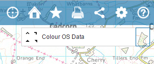
It is the same name shown here in the Web Map Layers 8.0 interface:

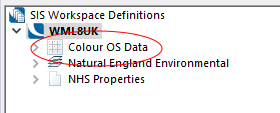
Here, the name of the Index Dataset in the SWD has been changed to match the name used in Web Map Layers 8.0:

You must make sure of the following:
- The overlay(s) you want to use for printing must all be renamed to match the Base Map layer(s) defined
- The overlay(s) are moved to the top of the list of layers in the SWD so that they appear beneath all other mapping
- The status is set to invisible
- Each layer has the WML::Ignore& with a value of 1 defined as an overlay property.
- All symbols used must be stored in the "Web Map Layers" folder of the required Named Object Library.
- The name of the symbol in the Named Object Library MUST be the the same as the image file name, without the file extension.

|
All default symbols are stored in the named objects library Web Map Layers Symbols.nol installed with GeognoSIS. You can usually find this read-only library in C:\Program Files\GeognoSIS\Libraries. To include a custom symbol, make a copy of the Web Map Layers Symbols.nol and create your symbol in the copy. See here for more information on creating symbols. Now overwrite the existing Web Map Layers Symbols.nol with your customised .nol |
Useful tips when creating a custom symbol
- Ensure the symbol is the correct size as this is how large it will appear in the PDF.
- Change the CRS linear units to mm for greater accuracy.
- To avoid a border around the symbol, set the pen style of the bitmap to blank in properties.
- When saving the symbol, ensure it is added to the Web Map Layers folder and that it is named the same as the original filename (minus the extension). If it is not, the symbol will not display in the NOL.
Send comments on this topic.