GeognoSIS SWD
This is the recommended method of adding data layers to your Web Map Layers 8.0 map.
Base layers cannot be added using the GeognoSIS SWD.
Adding data as a GeognoSIS SWD creates a more dynamic connection between the data and Web Map Layers 8.0. It allows you to make edits to the data in the SWD which will then be immediately visible when your Web Map Layers 8.0 site is refreshed.
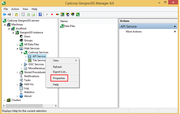
Before adding a GeognoSIS SWD layer you MUST enable GeognoSIS API for your GeognoSIS instance, this is done in the GeognoSIS manager. For your GeognoSIS instance expand the Web Services and then the Cadcorp Services and then right click API service and select Properties.

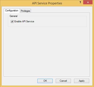
In the API Service Properties dialog, Configuration tab, make sure the Enable API Service tickbox is checked:

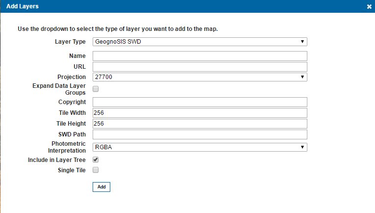
Adding the data

| Field | Is it Optional or Required? |
Description |
| Name | Required | An appropriate user added name. |
| URL | Required | The URL to the GeognoSIS Instance: http://ServerNameOrIPAddress:GeognoSISPortNumber/GeognoSIS/8.0 Only change ServerNameOrIPAddress and GeognoSISPortNumber, the URL must be appended with /GeognoSIS/8.0. |
| Projection | Required | Choose from a predefined list of SRID numbers to define what projection the data will be drawn in. More SRID numbers can be added in the Projections table of the webMapLayersConfig.db. |
| Expand Data Layer Groups | Optional | Any data layers grouped together will be initially expanded in the Map Features. |
| Copyright | Optional | Any text entered here will appear on the bottom left of your site. |
| Tile Width | Required | The data requests from GeognoSIS will be returned in tiles, the value here refers to the number of pixels wide that the tile of returned data will be. It is set to 256 as default. |
| Tile Height | Required | The data requests from GeognoSIS will be returned in tiles, the value here refers to the number of pixels high that the tile of returned data will be. It is set to 256 as default. |
| SWD Path | Required | Data needs to be stored on the same machine as your GeognoSIS Instance |
| Photometric Interpretation | Required | The colour interpretation of the data, this can be RGB (Red, Green Blue) or RGBA (red, Green Blue, Alpha) which takes into account opacity. |
| Include in Layer Tree | Optional | If this option is not ticked any overlays that are visible in the SWD will still be added to the map window, however they will not appear in the list of layers in the Map Features dialog. |
| Single Tile | Optional | Check this tickbox to draw a single image for the map. |
Send comments on this topic.