Open Street Map (OSM)
OpenStreetMap (OSM) is a collaborative project aimed at creating and providing free geographic data, this data can be added into WML to be used as base mapping.
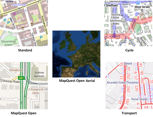
There are five products that are compatible for use within Web Map Layers 8.0 and they use the open source toolkit ‘Mapnik’ to render the data as a Slippy Map:

It is also possible to create your own cache of OSM mapping tiles from regular dumps of the whole OSM database at http://planet.openstreetmap.org/
Adding the data

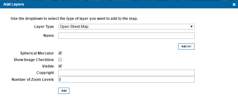
| Field | Is it Optional or Required? |
Description |
| Name | Required | An appropriate user added name. |
| Add URL | Required | The URL to the OSM tile server, this will be different depending on the type of OSM base mapping you wish to add. Multiple URLs can be added to allow concurrent requests to be made to the server. Further details on the required URLs can be found in the table below. |
| Spherical Mercator | Required | This defines if the map should act as a Mercator-projected map? (Mercator projection treats the earth as a sphere as opposed to a projection which treats the earth as an ellipsoid). This will cause all interactions with the map to be in the actual map projection, which allows support for vector drawing, overlaying other maps, etc. This is turned on as default. |
| Show Image Checkbox | Ignore | This option is present for legacy support of Web Map Layers 7.1, if using the standard Web Map Layers 8.0 site this parameter can be ignored. |
| Visible | Ignore | This option is not yet available in Web Map Layers 8.0, but has been added in preparation for future development. |
| Copyright | Optional | Text entered here will appear across the bottom left of your Web Map Layers 8.0 site. |
| Number of Zoom levels | Required | This value is dependent on the OSM product that is being added, appropriate zoom level values can be found in the table below. |
Required URLs
To add the tiles as a Slippy Map the appropriate URL needs to be passed to Web Map Layers, these are given in the table below. To increase the rendering speed of the map, multiple URLs can be used to make concurrent requests:
| Product Name | URL | Zoom Levels |
| Standard | http://a.tile.openstreetmap.org/${z}/${x}/${y}.png http://b.tile.openstreetmap.org/${z}/${x}/${y}.png http://c.tile.openstreetmap.org/${z}/${x}/${y}.png |
0-19 |
| Cycle | http://a.tile.opencyclemap.org/cycle/${z}/${x}/${y}.png http://b.tile.opencyclemap.org/cycle/${z}/${x}/${y}.png http://c.tile.opencyclemap.org/cycle/${z}/${x}/${y}.png |
0-18 |
| Transport | http://a.tile.opencyclemap.org/transport/${z}/${x}/${y}.png
http://b.tile.opencyclemap.org/transport/${z}/${x}/${y}.png http://c.tile.opencyclemap.org/transport/${z}/${x}/${y}.png |
0-18 |
| MapQuest Open | http://otile1.mqcdn.com/tiles/1.0.0/osm/${z}/${x}/${y}.jpg http://otile2.mqcdn.com/tiles/1.0.0/osm/${z}/${x}/${y}.jpg http://otile3.mqcdn.com/tiles/1.0.0/osm/${z}/${x}/${y}.jpg http://otile4.mqcdn.com/tiles/1.0.0/osm/${z}/${x}/${y}.jpg |
0-19 |
| MapQuest Open Aerial | http://otile1.mqcdn.com/tiles/1.0.0/sat/${z}/${x}/${y}.jpg http://otile2.mqcdn.com/tiles/1.0.0/sat/${z}/${x}/${y}.jpg http://otile3.mqcdn.com/tiles/1.0.0/sat/${z}/${x}/${y}.jpg http://otile4.mqcdn.com/tiles/1.0.0/sat/${z}/${x}/${y}.jpg |
0-11 (Globally) 12+ in the U.S. |

|
The use of /${z}/${x}/${y} means Open Layers will calculate zoom, x and y values for you. |
If a personal tile service is created using downloaded OSM data, then the URL corresponding to this should be used instead of those given in the table.
Send comments on this topic.