WFS (OGC Web Feature Service)
Adding an OGC Web Feature Service (WFS) adds actual features to the map, not just an image of the feature like a WMS.
Adding the data
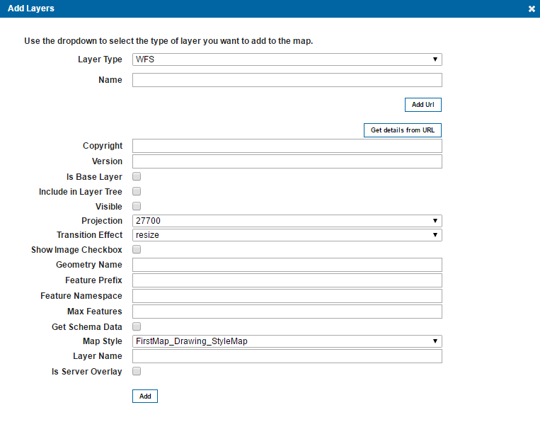
Firstly your data needs to be in GeognoSIS served out as a WFS, for details on how to do this see the section Serving out data using OGC services, then you can attain the URL from the capabilities document to add in Web Map Layers 8.0 admin dialog.
Firstly you need to add the URL, then fill in the rest of the parameters.
Selecting Get details from URL will populate most of the required features, you simply need to enter an appropriate name for the layer and set a Max Features value.
| Field | Is it Optional or Required? |
Description |
| Name | Required | An appropriate user added name. |
| Add URL | Required | URL attained from the WFS capabilities document, this can be accessed from the GeognoSIS Manager. |
| Get details from URL | Required | Select the layer from the WFS you wish to add to the site. |
| Copyright | Optional | Any text entered here will appear on the bottom left of your site. |
| Version | Optional | Automatically populated when you select a layer from the WFS. |
| Is Base Layer | Optional | Do you want the data to be served out as a base layer? |
| Include in Layer Tree | Optional | If the data is being served out as a base layer and the site will be accessed on a mobile device, this option allows you to switch between base layers in the Map Features dialog. (The base layer selector on the top right of the site is not included in the mobile version of Web Map Layers 8.0). |
| Visible | Optional | Defines if the layer is initially visible and turned on in the Map Features dialog. |
| Projection | Required | A predefined list of SRID numbers to define what projection the data will be drawn in. More SRID numbers can be added in the Projections table of the webMapLayersConfig.db. |
| Transition Effect | Required | This defines how the map transitions between zoom levels. Currently thereaaaa is only one option of resize, this resamples the current tile and displays it stretched or compressed until the new tile is available. |
| Show Image Checkbox | Optional | This option is present for legacy support of Web Map Layers 7.1, if using the standard Web Map Layers 8.0 site this parameter can be ignored. |
| Geometry Name | Required | Automatically populated when you select a layer from the WFS. |
| Feature Prefix | Required | Automatically populated when you select a layer from the WFS. |
| Feature Namespace | Required | Automatically populated when you select a layer from the WFS. |
| Max Features | Required | The Max Features value limits the amount of features returned from the WFS. As the WFS returns the actual vectors, not just an image, OpenLayers will collapse if a layer has more than approximately 200 vertices (depending on the browser). Limiting the amount of features will prevent this happening. |
| Get Schema Data | Optional | If the data being served out as a WFS has a schema applied to it, this schema will then be applied to the data as it is drawn on your web map layers site. |
| Map Style | Required | This defines the style in which the WFS features will be drawn. You can set it to use the Default Drawing Styles or Measuring Styles which are saved on a map by map basis in the admin interface (under the styles tab). |
| Layer Name | Required | Automatically populated when you select a layer from the WFS. |
| Is Server Overlay | Optional | This defines how the request is made to the WFS. If this option is ticked then a request is made to the WFS by the server, the response is then composed and then sent to the browser as a cache. If it is not ticked, the browser will make direct requests to the WFS to draw the features which will result in the site taking longer to draw the features. |
Send comments on this topic.