Spatial Filter
Spatial Filter creates a filter from the current item which can clip graphics in another overlay.
TIP: A note on Spatial Filters
Select  to open the Construct Spatial Filter dialog:
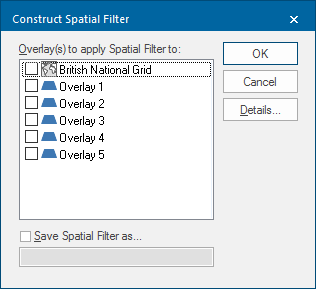
- Select the overlay(s) to apply the spatial filter to. All overlay items not inside the spatial filter are hidden. Use the Maps Control Bar to remove the spatial filter from the overlay.
- To save this spatial filter into the currently selected Library, check the option and enter a suitable name.
- Click Details to further explore the spatial filter options.
 display.png)
Test to apply - use the drop-down menu to select the geometrical test the spatial filter will use.
Component of item to test - drop-down box to select the geometry component that the spatial filter will compare against - their Extents, their Geometry or their Origin.
Benefits:
- Allows queries to be run on expressions added to the schema of a database spatial overlay. The time taken for queries depends on the size of the dataset.
- Users can select which overlays to create the spatial filter on. The overlay does not need to be visible.
Issues to be aware of:
- For spatial database dynamic overlays if the spatial extents of the possible result set is within the map window the query will perform relatively quickly. If the spatial extents go beyond the map window extents, the query may take longer.
- Best suited to spatial database Cached and One Off Import overlays.
- Queries are run on the client machine.
- If used for dynamic mode overlays any data required for the query will be retrieved from the database before the query starts this will use additional memory on the client.
- Attribute filters cannot be applied by this command.
TIP: For more information, see also: Spatial testing: Spatial Filter.