Types of Datasets
Memory Datasets
SIS Desktop 9 loads most file-based data as memory datasets.
This means the entire file is read into memory before the data can be displayed on screen. Once loaded in memory, performance and navigation is very fast.
Load times are dependent on the size of the file and memory available in the machine.
File sizes exceeding 50MB will inhibit performance; however this is subject to the amount of memory available for SIS Desktop 9 to use.
Examples of memory datasets include SIS BDS files, MapInfo .mif files and ESRI .E00 files.
Index Datasets
Certain datasets are supplied as files which geographically conform to a known grid.
For example Landline is based on the national grid. SIS Desktop 9 can read these types of files as index datasets.
Because the files are based on a known grid SIS Desktop 9 can automatically open and close these files according to the geographical area visible in the map window. This allows SIS Desktop 9 to use memory efficiently.
Examples of index datasets are OSGB products supplied in a tiled format such as OS Strategi and 1:50,000 raster.
Cursor Datasets
See Loading Data - Cursor Datasets
Cursor datasets generally reside in databases. Data is selected from the database according to the geographical area on display in the SIS Desktop 9 Map Window. A spatial index is used to work out the data required by SIS Desktop 9.
Examples of cursor datasets are .fdb files, .shp files (with a .prj file) and TAB files.
When creating an overlay using an RDBMS Cursor Dataset users can choose which type of connection to make to the database. Overlays can have one of three modes:
The mode can only be set at the time the overlay is created. Each mode gives the overlay different capabilities:
This mode reads the data into SIS Desktop 9 with the following characteristics:
- Data is selected from the database to fill the geographical extents of the SIS Desktop 9 Map Window. If the user pans to a new area SIS Desktop 9 requests the appropriate data from the database. This mechanism gives the impression that the overlay contains a seamless map base. It also facilitates efficient retrieval of data from the RDBMS cursor dataset by limiting the rows selected to just those that are required to fill the Map window. This mechanism allows spatial data to be retrieved from large RDBMS cursor dataset spatial layers while keeping network traffic to a minimum. Dynamic mode can only be selected if the spatial layer/table has a spatial index associated with it.
- Data is read in a manner that utilises memory efficiently; as users pan around the map the memory is constantly flushed, ensuring there is no loss of performance.
- When the map is refreshed (e.g. if the map is panned, zoomed, etc) or a feature is selected the data is immediately retrieved from the database.
- If the overlay was created by connecting to the database as the owner of the layer or as a user who has the following privileges: select, inset, update, delete the overlay will be created with a status of editable.
- Ensures that the latest version of the feature is being displayed when the map is panned or a feature is selected.
- Edits made to the data displayed in the map window will be reflected in the RDBMS cursor dataset immediately.
- Subject to database privileges the data is editable.
- The underlying database table structure in the RDBMS cursor dataset can be adjusted using SIS Desktop 9. Columns (attributes) can be added or removed.
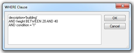
- The Database Query can be used to create spatial and attribute filters. The Query Wizard applies a ‘where’ clause to the SQL select statement used to extract the data from the database. The Database Query Wizard can only be used to run attribute queries on attributes that exist as columns in the underlying RDBMS cursor dataset table.
This mode reads the data into SIS Desktop 9 with the following characteristics:
- Data is always displayed in read only mode.
- The dataset is only refreshed/synchronised when the SWD is opened.
- Data is cached on the client, this allows for fast data interrogation.
- Client server communication is kept to a minimum.
- Unless the spatial filter is applied when creating the layer the entire spatial layer/table will be selected by the client. Users are advised to always apply the spatial filter and ensure the SIS Desktop 9 Map Window extents are set correctly for your data.
- If the SIS Desktop 9 map view extents are set incorrectly there is a possibility that SIS Desktop 9 will run out of memory, this is dependent on the client machine memory and the amount of data being selected from the database.
This mode reads the data into SIS Desktop 9 with the following characteristics:
- Data is copied from the database table into an internal overlay. The overlay generated by a one-off import should be considered as a ‘snap-shot’ of the database.
- The data in the overlay is editable but does not edit data held in the database table.
- Creates a copy of the data on an internal overlay.
- The internal overlay is never refreshed/synchronised with the data in the database.
- Optional annotations cannot be set when creating a one off import overlay. This can be done using Add Theme and specifying a label theme based on the attribute that contains the text information to be displayed.
- Unless the spatial filter is applied when creating the layer the entire table will be selected by the client. Users are advised to always apply the spatial filter and ensure the Cadcorp SIS Desktop Map Window extents are set correctly for your data (see Setting SIS Map Window View Extents). If the Cadcorp SIS Desktop map view extents are set incorrectly there is a possibility that Cadcorp SIS Desktop will run out of memory, this is dependent on the client machine memory and the amount of data being selected from the database.
Note: To interrupt the creation of either a Cached Mode or One Off Import Mode data retrieval process press Ctrl+Alt+Break. This is particularly useful when users attempt to create a one off import or a cached mode overlay from a spatial database and forget to specify a Spatial Filter Intersect with current extent in the Spatial Object-Relational WHERE Clause dialog (Oracle dialog shown as an example).