OGC Gazetteer
Acts as an OGC Gazetteer Service client downloading location information over the internet from an OGC Gazetteer Service.
Click Home > Gazetteer and select OGC Gazetteer from the drop-down list.
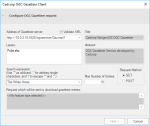
1. Type in the name of the Gazetteer server address if you know it. Previously used server addresses are remembered in the drop-down menu.
2. Select Validate XML for SIS Desktop 9 to automatically validate any returned metadata for accuracy.
3. Layers available in the OGC gazetteer are automatically displayed. Select any specific layers you require. (The example above has Pubs as a layer)
4. Type in the expression you wish to search for or click the drop-down menu to see previously searched for expressions.
5. Enter the Max.Number of Entries you want the search results to display.
6. Specify the request method to be used. (We recommend the default GET)
7. Click Next to see search results.
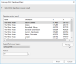
8. Simply click on any of the table headers to sort the results (alphabetically or numerically)
9. Select any result and click Preview to locate the result’s location in the map window.
10. Adjust your radius (in metres) for a more accurate preview display. (A higher radius shows a zoomed-out map view)

