File
Use File to load any of your datasets (eg Shape, MID/MIF, DGW, ECW, EML, AutoCAD DXF, BDS, etc.) as overlays; these files then remain stored on your disk.
Click Add Overlay > Files > File.
The SIS Workspace Definition (SWD) stores a link to the dataset. If the dataset is modified, all SWDs with links will reflect the changes.

External datasets are loaded as non-editable overlays (if you want to edit these files use the Imported File option to load copies of them instead). However BDS files (which contain user data) are loaded as editable overlays.
 example1.png)
Select the required dataset file and click Finish.
The Configure button is activated if you choose any configurable datasets. Configuration data is stored in the SWD.
TIP: Use the file type drop-down box to restrict what could potentially be a long list of files to only those of the required type.
Configurable dataset types include :
- ESRI ARC/INFO ASCII Grid (*.asc)
- ENVISAT Image Product (*.n1)
- JPEG (*.jpg, ; *.jpeg)
- PCI .aux Labelled (*.aux)
- AutoCAD DXF (*.dxf)
- OGC GML (*.gml)
In this example a satellite image is selected (SS32NW.tif),
Click Configure.
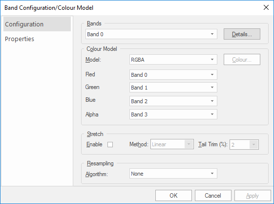
The Band Configuration/Colour Model dialog will be displayed. The two tabs available on this dialog are Configuration and Properties.
Configuration tab:
Click the Details button for more information on the current band. For eg Band 0 may show Properties and Histogram. Properties shows the properties and values applicable to the selected band. Histogram displays a histogram of the selected band.
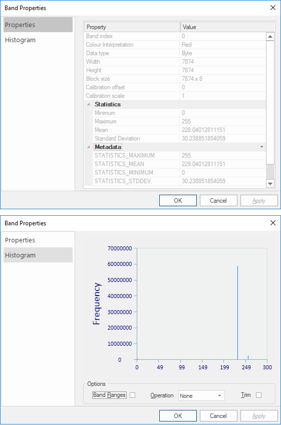
- Band Ranges - annotates the histogram display with minimum and maximum values.
- Operation - the drop-down box allows the selection from None, Accumulation, Equalization and Proportion.
- Trim - Excludes the extreme values in the selected band range.
Depending on the dataset type you choose these colour models may be available to you.
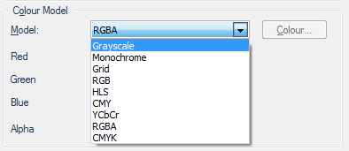
- Grayscale - allows only one band to be set.
- Monochrome - allows only one band to be set. The Colour... button becomes active to allow the colour of this band to be selected using the standard Windows Color display.
- Grid - allows only one band to be selected.
- RGB - allows three bands to be set as Red, Green and Blue.
- HLS - allows three bands to be set by Hue, Luminosity and Saturation.
- CMY - allows three bands to be set as Cyan, Magenta and Yellow.
- YCbCr - allows three bands to be set by Luminance, Blue-difference and Red-difference.
- RGBA - allows four bands to be set; three as Red, Green and Blue, plus an Alpha channel.
- CMYK - allows four bands to be set as Cyan, Magenta, Yellow and Black.
Sometimes the range of reflectance values collected by a sensor may not match the capabilities of the film or color display monitor. This is a common problem in remote sensing.
The range of brightness values on an image is referred to as contrast. Contrast enhancement is a process that makes the image features stand out more clearly by making optimal use of the colors available on the display or output device.
Enhancements involve changing the range of values in an image in order to increase contrast. For example, an image might start with a range of values between 40 and 90. When this is “stretched” to a range of 0 to 255 the differences between features is accentuated.
Check to tickbox to enable Stretch and select from the available methods in the drop-down menu.
- Linear - Linear contrast enhancement (also known as contrast stretching) linearly expands the original digital values of the remotely sensed data into a new distribution. By expanding the original input values of the image, the total range of sensitivity of the display device can be utilized. Linear contrast enhancement also makes subtle variations within the data more obvious. These types of enhancements are best applied to remotely sensed images with Gaussian or near-Gaussian histograms meaning all the brightness values fall within a narrow range of the histogram and only one mode is apparent.
A nonlinear stretch expands one portion of the grey scale while compressing the other portion This sort of enhancement is typically applied with the purpose of 'favouring' one part of the brightness range. While spatial information is preserved, quantitative radiometric information can be lost. The type of nonlinear enhancement chosen depends on the nature of the original data and what features the user is interested in. For example water features (typically darker in tone) benefit from logarithmic or square root stretches. - Square Root - A square root stretch compresses the higher brightness values within an image and disproportionately expands the darker values. It is applied by taking the square root of the original brightness values. Thus the original darker values are given a greater relative contrast than the original values at the higher end of the brightness scale. This is done to allow better visual discrimination among the darker features of the image while maintaining some limited recognition of the brighter features.
- Logarithmic - The logarithmic stretch is a more vigorous version of the square root stretch. It allows the easy specification of a stretch where the display transfer function rises very sharply at the low end and changes more slowly at the high end,. This raises the contrast of the dimmer pixels and decreasing contrast (but increasing brightness) of the brighter pixels.
- Exponential - This is a non-linear radiometric enhancement technique where high-range brightness is enhanced and high histogram skew can be corrected. Details in the higher part of the dynamic range are revealed.
- Equalization(Histogram equalization) - A histogram-equalization shifts brightness values based on their frequency of occurrence (number of pixels that carry that brightness value). If a brightness value has many pixels associated with it, it is given a new grey level value that is farther away from its lower neighbour; this improves their relative contrast. The function to be applied is the equivalent of the cumulative brightness histogram of the image.
- Negative - The highest and lowest intensity values are stored. The threshold value is calculated as the average of these points. This is particularly effective with bimodal images.
TIP: For examples of image stretching results using the different methods see Image Stretching.
- Tail Trim(%) - range 1% - 5%. Tail trimming refers to the exclusion of the extreme values in the band ranges used on a given stretching operation. This improves results by removing no-value data which tend to appear at the tails of a range.
Altering the size of a digital image is called resampling (also known as interpolation or down-sampling). Choose the resampling algorithm best suited to your needs.
- None - No resampling algorithm will be applied. This is the default value.
- Nearest Neighbour - This is the simplest method of resampling and basically makes the pixels bigger. The colour of a pixel in the new image is the colour of the nearest pixel of the original image. If an image is enlarged, one pixel will be enlarged to a 2 x 2 area of 4 pixels with the same colour as the original pixel. The downside with the Nearest Neighbour method is that the images may look very “blocky” when scaled up in size.
- Bilinear - This method is more sophisticated than the Nearest Neighbour method; it averages 4 neighbouring pixels to produce the new pixel colour values in the resampled image. The advantage of this method is that all of the original pixels contribute to the new pixel values. There are less jagged edges and the overall look is smoother than the Nearest Neighbour option. However this does introduce new averaged colours not necessarily found in the original. Edge contrast in the original is also averaged and may appear blurred in the resized document.
Bilinear resampling also takes considerably longer to process than the Nearest Neighbour method (3 to 4 times longer). This method is more suited for resampling photographic images. The resulting images are much smoother than those produced by the Nearest Neighbour method but are not as sharp or as smooth as an image computed using Cubic or Cubic Spline resampling. - Cubic - This method determines the grey level from the weighted average of the 16 closest pixels to the specified input coordinates, and assigns that value to the output coordinates. This method is closer to the perfect sin(x)/x resampler than Nearest Neighbour or Bilinear resampling. The image is slightly sharper than that produced by Bilinear interpolation, and it does not have the disjointed appearance produced by Nearest Neighbour interpolation. Because the grey level values are altered by this method, any image classification processes should be performed before the interpolation. The Cubic resampling method requires about 10 times the computation time required by the Nearest Neighbour method.
- Cubic Spline - With this method, the image is divided into squares of 4 pixels x 4 pixels, the behaviour of colour within each 16 pixel group is used to more accurately predict the appearance of the new resampled pixels. This is resampling method normally produces the most pleasing results. It is also the slowest of the resampling methods and is most appropriate for use with photographic images.
- Lanczos - This method can be useful when the resampled image is intended for viewing identification of detailed features or boundaries. When the resampled image will subsequently be analyzed or processed, Lanczos resampling can increase the ability to detect edges and linear features.
Click OK on the Band Configuration/Colour Model dialog and click Finish on the Browse for dataset file(s) dialog.