JPEG 2000 (*.jp2)
ECWJPEG2000 Format.
Export as a compressed JPEG 2000 image (*.jg2). Georeferencing information is embedded within the file. JPEG 2000 uses compression techniques based on wavelet technology. Images become blurred with higher compression ratios.
When exporting to JPEG 2000 (*.jp2) the following JPEG 2000 dialog is displayed:
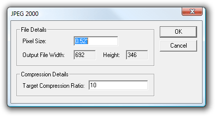
File Details
Pixel Size
This option specifies the width of a pixel in coordinate system units.
This is the size of the pixel on the ground (in metres) that you wish to use. This will determine the resolution of the image you create.
Output File Width/Height
This option specifies the output file size in pixels for width and height and the pixel size is in map units.
Compression Details
Target Compression Ratio
This is an indication of by how much you wish to compress the image. It determines how many levels will be created in the ‘pyramid’ data structure used by ECW. Entering a value of 100 here will not compress the data as much because it will need to create 100 different scale views of the data to build the ECW. If compression is the main reason for conversion to ECW, enter a low figure here. These figures also determine the time it will take for the export to complete.
Arguments to Export API Method
- clsExport$
JP2KAK_GDALExporter
Compatibility:
- Cadcorp SIS Desktop
- Cadcorp SIS ActiveX Modeller
