Using a REST Client
Enter the following URL into the appropriate REST client, adding the server name and server port number. Use the GET method. We are asking for the response to be returned using JSON by adding the .json parameter.
http://localhost:4444/geognosis/9.json
http://servername:instance_port_number/geognosis/9.json
Servername is the name or IP address of the GeognoSIS server
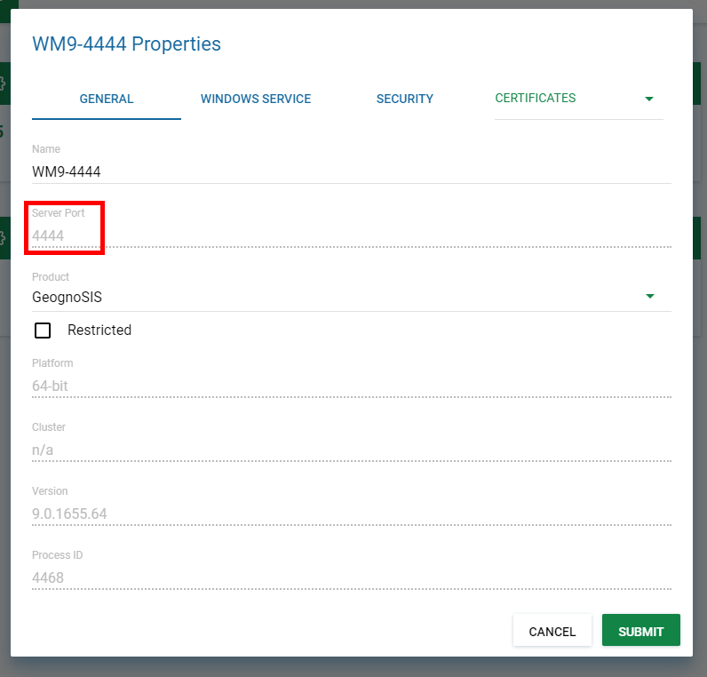
Instance_port_number is the Server Port number being used by the instance of GeognoSIS, defined in the instance Properties.
You should get the following response. This displays the paths available at this level:
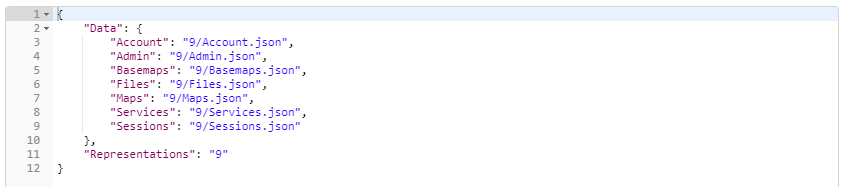
You can start to move around the structure using the paths available.
For eg to see which data files (usually SWDs) are currently available and served as Maps, use the following GET request:
GET http://server:port/geognosis/9/Maps.json
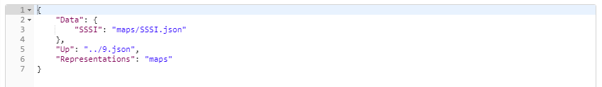
Here there is one Map (SWD) called SSSI. Just extend the URL in use to examine further the structure of the SWD.
Use the OPTIONS request to see the operations currently available to you. For example using OPTIONS with following request will return:
GET http://server:port/geognosis/9/maps.json
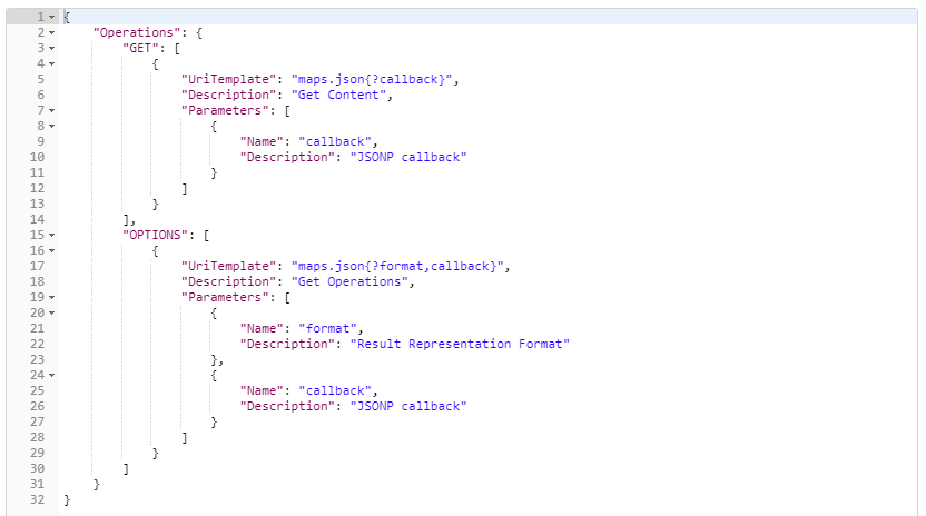
Because we are viewing preloaded Data Files these are read only. This limits the available requests to GET only.
At the top level of the API you have access to these options:
- Account – displays authentication and security set on the GeognoSIS instance.
- Admin – provides access to the GeognoSIS HTTP Admin API.
- Files - Files\Home.json gives access to files and folders of the home directory of the account you used to connect to GeognoSIS (usually the Guest account, unless you use non-anonymous authentication). You can edit the home directory with GeognoSIS Manager.
You need administrator username and password to access this section of the API.
Passwords can be added to the requests as parameters, specifying the password either as plaintext ("pwd":"plaintext:secret") or encrypted with the public key of one of the installed certificates ("pwd":"encrypted:<base64-data>"). The new HTTP API resource .../Certificates/PKI.[cer|json] returns the suggested certificate for encrypting passwords.
The new HTTP API resource .../Certificates/SSL.[cer|json] returns the currently selected SSL certificate SSL, if present. Basemaps - Basemaps.json gives access to .bdb files in the GeognoSIS\Basemaps\folder. Get the .bdb tiles from this folder if you want to access a GeognoSIS tile cache.
Files\Shared.json gives access to the files and folders of the virtual data folder specified in GeognoSIS Manager. You can create and delete folders, dataset files and NOLs there. You can use it as a private or shared scratch area.
With APIs such as NolInsert or InsertDataset you can specify either an absolute file path, or a relative URL to a matching file resource somewhere below Files.json.
- Maps – displays the Maps defined in the GeognoSIS Manager.
- Services – provides access to the services defined on the instance. These are split into Cadcorp (Tile, TileCache), OGC (WMS,WFS and WMTS) and OSGeo (TMS).
- Sessions – displays the sessions currently accessible on the GeognoSIS instance.