Isochrones
Isochrones show not just the physical distance between places but the amount of time it takes to get from one spot to another.
Select Analysis > Routing > Isochrones.
This opens the Isochrones dialog: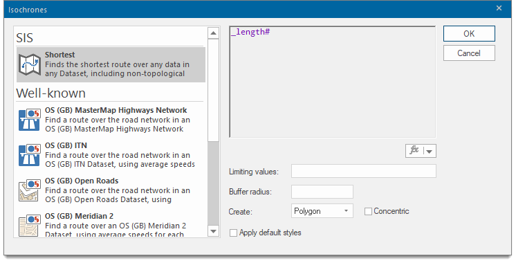
Select one of the options.
- Shortest - Show all locations that can be reached via a route shorter than the distance entered as a Limiting value
- Well-known- choice of well-known mapping networks.
- Custom Expression - Select this option to use an expression to calculate the isochrone. For example, an expression may be used to take into account the speed limits on the roads in order to calculate an isochrone based on time rather than distance.
Well-known Route options
TIP: Many of these options are similar to the ones available in other routing options.
- OS (GB) MasterMap Highways Network
- OS (GB) ITN
- OS (GB) Open Roads
- OS (GB) Meridian 2
- OS (GB) Meridian 2 (Motorways and A Roads)
Custom Expression
You can also use the SQL Control Bar from the View ribbon tab to create routes.
For instance to create a route from each Fire Station to each Incident that the Station responded to, you can create a SQL statement as follows.
.create stationIncidents
Select st_findroute(Incidents.sis_geometry,Stations.sis_geometry,
'{"OSRM":{"File":"British Isles.osrm"}}')
from Incidents join Stations on Incidents.Station_Name = Stations.Station_Name;
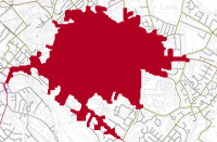
Creating an isochrone (Example):
- Select Analysis > Routing > Isochrones.
- Scroll down the list to select OS (GB) ITN.
- In the Limiting value edit text box, type the value 2 (this is a route cost of 2 mins)
- Set the Buffer radius to 50 •
- From the Create dropdown, select QZone
- Tick the Apply default styles tickbox
- Click OK.
- Click on the map at your chosen start position.
-
The Isochrone is created
as below.