What is a Spatial Database?
A Spatial Database is any database optimized to store and query data related to objects in space, including Point, LineString and Polygon items.
Advances in relational database management technology mean users now have the option of storing their GIS data in a spatial database rather than traditional file-based storage.
SIS Desktop 9 is compatible with these industry-standard spatial databases:
- Oracle (using Locator or Spatial option)
- SQL Server 2008 (Spatial)
- PostgreSQL (with PostGIS)
Benefits of using a spatial database compared to file-based data storage:
| File based Storage | Database | |
|
File size |
usually limited to 2Gb |
Unlimited |
|
Client Memory Usage |
Memory-intensive |
Memory efficient |
|
Multi-user Access |
Only crude control, if any |
Multi-user access is supported |
|
Managing data |
Difficult to manage, data may become duplicated |
Central storage of data, easy |
|
Security |
File system security |
Built in security access to data |
|
Spatial Analysis and |
Carried out on the client (hence limited to client capability) |
Carried out on the Server. |
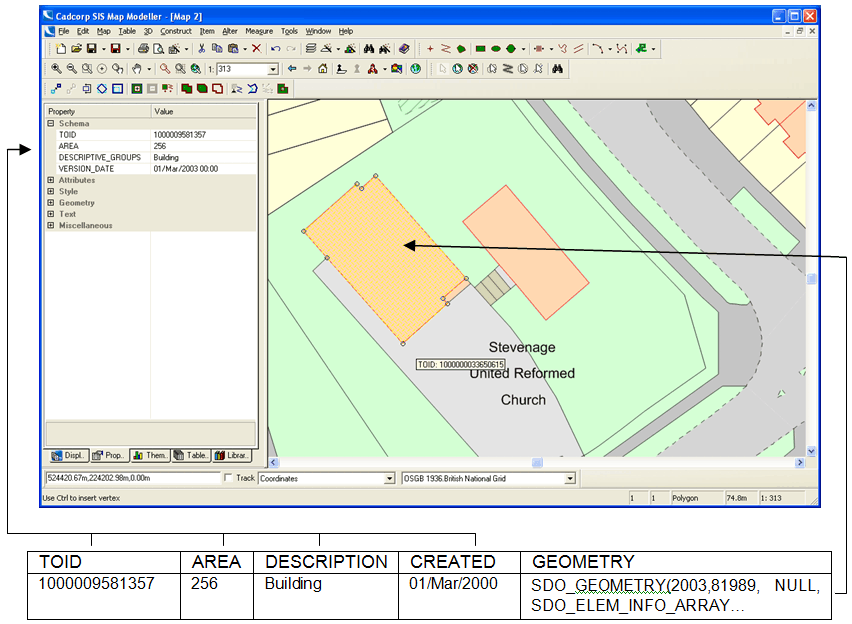
Spatial data is stored in database tables, each spatial feature corresponds to a row in the table.
The spatial feature itself is stored in a special geometry type that is available in all three databases. The attribution data associated with each spatial feature is stored in the same table row, each attribute corresponds to a column in the table.
The following figure shows the relationship between a spatial feature displayed in Cadcorp SIS Desktop and how it is stored as a row in the database table.