Loading maps (and other data files)
After creating a new SIS Workspace Definition (SWD), you are now ready to display maps and other data files (including database files).
These files are called datasets.
Datasets are loaded in Cadcorp SIS Desktop as overlays. An overlay is a view of a dataset. There is no limit to the number of overlays which can be included; each one can also have a different projection.
You can simply drag and drop any datasets to load it into the current session or use the Add Overlay (Home > Map) dialog.
You can drag and drop datasets on:
- the Maps Control Bar.
- Map Windows, Table Windows or 3D Windows
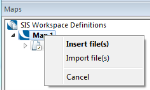
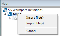
If you drag a dataset using the right mouse button you can choose:
- Insert file(s) - load as a normal overlay, or
- Import file(s) - make an editable copy
Adding an Overlay
Use one of the following methods to add an Overlay:
- choose Add Overlay (Home > Map)
- choose Add Overlay... from the SWD’s local menu in the Maps Control Bar.
- Press function key F2 while control is in the Map Window.
Each of these methods will display the Overlays dialog. See also Add a New Overlay.
New map formats are always being added. If the format you wish to use is not supported contact Cadcorp for the latest information or visit our website (www.cadcorp.com).