Add Orthogonal Grid- Print Templates
This option allows you to show eastings and northings by means of grid lines and/or annotation.
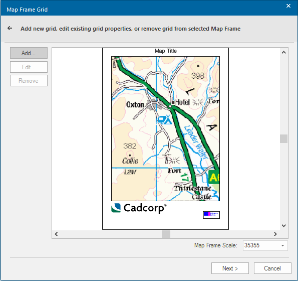
- On the Map Frame Grid dialog select the map frame that needs a grid (a template can contain more than one map frame item).
- If you have already created any grids and saved them as named objects, the Edit and Remove buttons are enabled. Otherwise click on Add.

-
Click on the Add button and in the Properties of Map Frame dialog give the parameters for the grid.
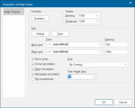

The Properties of Map Frame dialog is the standard properties dialog for map frames and allows you to change other parameters as well as those of the grid.
You can choose:
-
which overlays will be shown in the map frame(Overlays)
-
the scale of the map frame contents (Drawing scale), and optionally, a generalisation scale (Thresholdscale). The Threshold scale means that only those items which would be visible at that scale on the map SWD will be visible in the print template map frame item, irrespective of the Drawing scale of the print template.
-
to create a default grid using the current settings (Default)
-
to clear the grid from the map frame(Clear)
When deciding how the grid lines should appear, you can choose:
- the Pens and their Spacing to be used for both Minor grid and Major grid lines
- if the grid lines are shown or just the annotation (Show Lines)
- if annotations are displayed along the edges (Edge Annotation), and whether the special annotation at the corners is shown (Corner Annotation)
- the appearance of the annotation text (Text Height and Font)
- if annotations are shown in full or abbreviated so that only the changing portion of edge annotation is shown (Abbreviate annotation)
- if text, which would normally appear upside down when viewed from the bottom of the map frame, should be flipped (Flip inverted text)
TIP: Most of the options you specify here become properties of the map frame and can be changed later in the map frame’s Properties dialog.
- Click on OK and you will see the grid applied to the print template.
If the map frame contents have been rotated, the grid lines are roated correspondingly.
Rotation angles between 0° and 45° display eastings along the bottom and top of the map frame. Angles between 45° and 90° display eastings along the left and right sides.
Grid lines will always be drawn on top of the map frame contents.