Publish to PDF- Options Settings
To publish the current map window as an Adobe PDF file, select File > Publish > Publish to PDF
To export useful information to your PDF, use the Options tab.
- Export hyperlinks to external resources
- Export layer information
- Export geospatial measurement information, geospatial coordinate systems and OGC GeoPDFmetadata
Cadcorp SIS Desktop supports the Adobe® Acrobat® viewport and measurement tag functionality when exporting to an Adobe® Acrobat® PDF document.
Note: Some of these features are only available with the Adobe® Acrobat® Standard or Professional version 7.0.8 or above, they are not provided with Adobe® Acrobat® Reader®.
Layer awareness may be maintained when exporting to a PDF by ticking the appropriate Layers option in the Options tab.
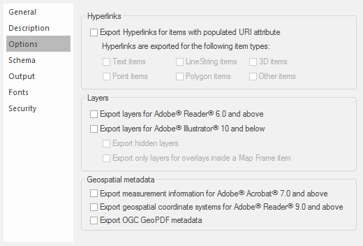
Hyperlinks
| Options- Hyperlinks | Description | |
| Export Hyperlinks for items with populated URI attribute |
Exports hyperlinks to external resources for items whose _URI$ attribute is not empty. |
|
|
Hyperlinks are exported for the following item types |
Select as required from six item types shown: Text items, LineString items, 3D items, Point items, Polygon items, Other items |
|
In an exported PDF you may find the exported hyperlinks are only selectable, ie the pointer cursor changes to a hand cursor at a very close range from the linked item. To increase the selection range see Hyperlinks to external objects - Hyperlinks in PDF output.
Layers
| Options- Layers | Description | |
| Exportlayers for Adobe® Reader® 6.0 and above |
Exports layer information so that Adobe® Reader® 6.0 and later can display each overlay as a separate layer. |
|
| Exportlayers for Adobe® Illustrator® 10 and below |
Exports layer information so that Adobe® Illustrator® 10 and previous versions of Adobe® Illustrator® can display each overlay as a separate layer. |
|
| Export hidden layers |
Exports hidden overlays as hidden layers instead of ignoring them. |
|
|
Export only layers for overlays inside a map frame item |
Suppresses the layer information for top-level overlays and Map Frame items contained within them. If this tickbox is unchecked the layer structure of the exported pdf will include the Frame and Map Frame, for example: This option gives control over visibility of the entire Map Frame. If this tickbox is checked the pdf will be exported with control of only the layers inside the Map Frame, for example: This means there is no control over the frame which will be permanently visible. |
|

Geospatial metadata
| Options - Hyperlinks | Description | |
|
Export measurement information forAdobe® Acrobat® 7.0 and above |
Specifies whether or not measurement information will be inserted into the PDF document. Adobe® Acrobat® 7.0 is capable of measuring lengths and areas in coordinate reference system units if such measurement information is present in a PDF document. |
|
| Export geospatial coordinate systems forAdobe® Reader® 9.0 and above | Specifies whether or not geospatial coordinate systems will be inserted into the PDF document. | |
| Export OGC GeoPDF® metadata | Specifies whether or not GeoPDF® metadata will be inserted into the PDF document. GeoPDF® metadata enables the functionality of the OGC GeoPDF® plugin for Adobe® Acrobat® | |
The viewport and measurement tag functionality allows users of Adobe® Acrobat® Standard or Professional version 7.0.8 or above to perform real world measurements on mapping data contained within an Adobe® PDF document.
Measurements include Distance, Perimeter and Area. This functionality is available within Adobe® Acrobat® Standard and Professional from the Tools/Measuring command.

To activate viewports and the ability to use measurement tools, tick the Export measurement information for Adobe® Acrobat® 7.0 and above box in the Options tab when exporting to an Adobe® PDF document.
Currently only viewports (coordinate systems) measured in metres/feet/miles etc. in x and y coordinates are supported.
Note: Adobe® PDF documents created with activated viewports do not have unlimited accuracy. Instead every vertex created during the measurements are snapped on to a grid created according to the resolution chosen, i.e. 300dpi, 600dpi, 1200dpi. A greater resolution should improve the accuracy of the results returned.
Even though the vertex coordinates within the Adobe® PDF document may be exactly the same as those within Cadcorp SIS Desktop it is highly unlikely the measurement values provided by the system will exactly match. This is because Adobe® Acrobat® may use a different algorithm to perform its measurements and there is no such thing as true, real, exact, correct values. Each value is an approximation.