ESRI Shape (*.shp)
Exports an ESRI ArcView Shapefile.
The ESRI Shapefile is the non-topological based file format for the ESRI AcrView / ArcGIS suite of products. It is an openly specified file format and is regularly used as a common data transfer format as many systems are capable of reading the format.
Each file can only store a single type of geometry e.g. Points, LineString or Polygons items. Most features are stored as simple features, i.e. true curves are not stored.
Shapefiles consist of multiple file components, the three core ones being the .shp, .dbf and .shx. The table below gives a brief description of the most common components.
| Component | Description | |
| .shp | Contains the geometry information. | |
| .dbf |
Contains attribute information dbf column names are limited in length to 10 characters and each table can only contain 255 columns. |
|
| .shx | Geometry index information. | |
| .prj |
Coordinate reference system information. Note: This is stored in ESRI WKT not standard WKT. However when a recognised prj is present SIS will attempt to read the file as cursor not memory-based. |
|
| .sbn .sbx | These are spatial Index files. | |
| .shp .xml | Contains metadata information. | |
SIS Desktop 9 creates on export the .shp, .dbf, .shx and .prj.
Select the appropriate overlay and select the geometry type to export.
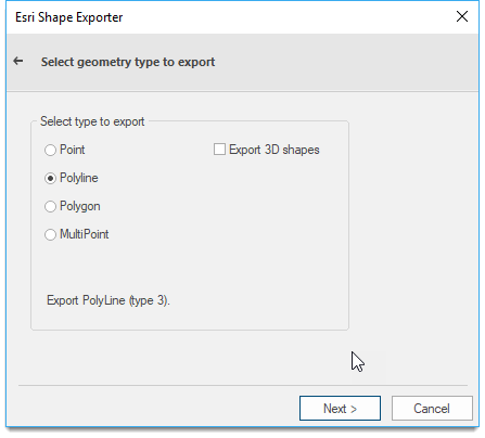
Click Next.
The ESRI Shape Exporter dialog also allows the customisation of the column width in the .dbf file:
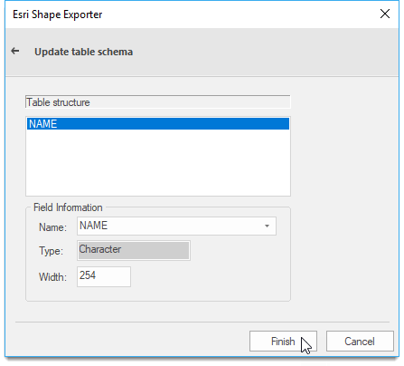
This can have significant file size benefits if the columns are reduced below the standard settings where applicable.
Click Finish.
Arguments to Export API Method
- clsExport$
-
- AArcInfoShapeExporter
- AArcInfoShapeExporter
- params$
- [index=nOverlay,][type=nType]
index - The position in the overlays list of the overlay to export. The default value is0.
type - The type of Shape file to create. The default value is0.0Point
1PolyLine
2Polygon
3MultiPoint
10PointZ
11PolyLineZ
12PolygonZ
13MultiPointZ
- [index=nOverlay,][type=nType]
Note: An accompanying .PRJ file is created if the current Coordinate Reference System is identifiable as an EPSG Code, and there is a ESRI WKT for that code.
Compatibility:
- Cadcorp SIS Desktop
- Cadcorp SIS ActiveX Modeller
- Cadcorp SIS ActiveX Manager
- Cadcorp SIS ActiveX Viewer
- Cadcorp GeognoSIS
