Tiff (Palette) (*.tif)
Exports as a palette TIFF (Tagged Image File Format) image.
TIFF is a container format including images and data within a single file with header files describing the internal properties such as the size, definition and applied compression.
When you use this command, the extents of the saved image are not necessarily those of the view you see on screen. What is saved is the extents of your last zoom. In the case of raster data, the image dimensions are forced to match the aspect ratio of the current view.
Select File > Export > Export to File and select Tiff (Palette).
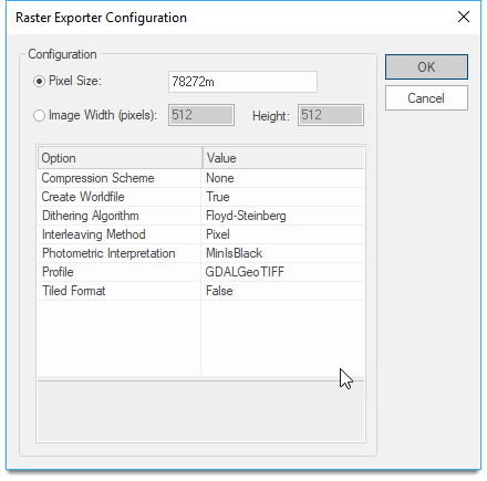
| Option | Description | |
|
Pixel Size |
Specify the image resolution- simply click to open the drop-down menu. |
|
|
Image Width/Height |
Specify the output file size in pixels for width and height and the pixel size is in map units. |
|
|
Compression Scheme |
Select from Fax3, Fax4, None or RLE. |
|
|
Create Worldfile |
True or False, to create worldfile containing georeferencing information. |
|
|
Dithering Algorithm |
Select from Dither (GDI), Floyd-Steinberg, Snap (GDI), Snap (Palette). |
|
|
Interleaving method |
Select from Band or Pixel. |
|
|
Photometric Interpretation |
The colour space of the image data, select MinIsBlack or MinIsWhite. |
|
|
Profile |
File structure, select from Baseline, GDALGeoTIFF, GeoTIFF. |
|
|
Tiled Format |
Switch to tiled format, True or False. |
|
Arguments to Export API Method
- clsExport$
GTiffPalette_GDALExporter
Compatibility:
- Cadcorp SIS Desktop
- Cadcorp SIS ActiveX Modeller
- Cadcorp SIS ActiveX Manager
