ERDAS ECW Image (*.ecw)
The Earth Resource Mappings ECW format is used to achieve high compression for image data. In GIS it can be used for satellite imagery and aerial photographs. ECW uses ‘wavelet’ technology to view part of the image at the required view scale. ECW has no file size limit for reading data and allows unlimited size export.
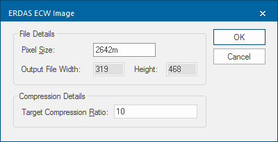
Select the ERDAS ECW Image (*ecw) option from the dropdown list. The ERDAS ECW Image dialog will be displayed:
| Option | Description | |
| Pixel Size | The width of a pixel in coordinate system units. | |
| Output File Width | The width in pixels of the bitmap to create. | |
| Output File Height | The height in pixels of the bitmap to create. | |
| Target Compression Ratio |
This is an indication of by how much you wish to compress the image. It determines how many levels will be created in the ‘pyramid’ data structure used by ECW. Entering a value of 100 here will not compress the data as much because it will need to create 100 different scale views of the data to build the ECW. If compression is the main reason for conversion to ECW, enter a low figure here. These figures also determine the time it will take for the export to complete. |
|
Note: Unlimited export to ECW is only available within SIS Desktop 9 and that export coverage is determined by the extent of the map window.
Arguments to Export API Method
- clsExport$
Compatibility:
- Cadcorp SIS Desktop
- Cadcorp SIS ActiveX Modeller
