JPEG 2000 (ER Mapper ECW) (*.jp2;*.j2k;*.jpc;*.jpx;*.j2c)
ECWJPEG2000 Format.
Export as a compressed JPEG 2000 image (*.jg2). Georeferencing information is embedded within the file. JPEG 2000 uses compression techniques based on wavelet technology. Images become blurred with higher compression rates. Compression can be lossy or lossless.
When exporting to JPEG 2000 (*.jp2;*.j2k;*.jpc;*.jpx;*.j2c) the following Raster Exporter Configuration dialog is displayed:
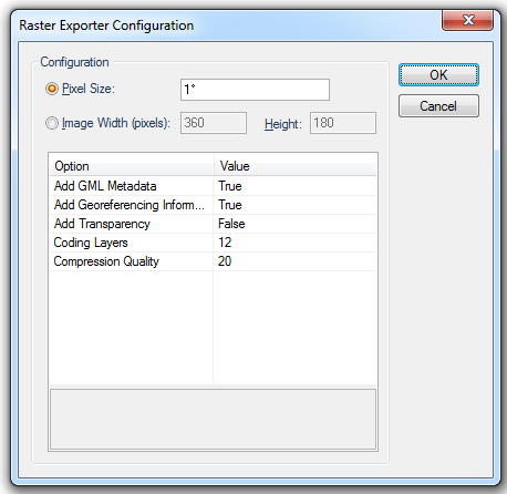
Configuration
Pixel Size
This option specifies the image resolution.
Image Width/Height
This option specifies the output file size in pixels for width and height and the pixel size is in map units.
Add GML Metadata
Include GML box in the imagery file using the GMLJP2-metadata standard, True or False.
Add Georeferencing Information
Include georeferencing information in imagery file using the GeoJP2 format extension, True or False.
Add Transparency
Create alpha channel, True or False.
Coding Layers
Enter the number of coding layers in the range 1 to 20. The image quality increases monotonically with each layer.
Compression Quality
Select in the range 100 - 1. 100=good (lossless), 1=bad.
Arguments to Export API Method
- clsExport$
JP2KAK_GDALExporter
Compatibility:
- Cadcorp SIS Desktop
- Cadcorp SIS ActiveX Modeller
