OGC KMZ (compressed KML) (*.kmz) (Google Earth)
KMZ files are zipped .KML files, which make them easier to distribute and share with multiple users.
An XML-based language to represent and style geometry in 2D and 3D.
Originally associated with Google Earth, it is now an OGC standard, officially named as the OpenGIS KML Encoding Standard (OGC KML). Represents 3D coordinates using Latitude/Longitude (WGS84).
If the SWD contains more than one overlay, the SIS Overlay dialog will be displayed:
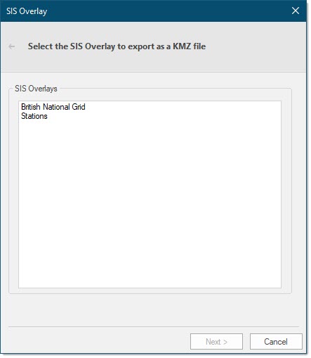
Select the required overlay and click Next.
The Export Configuration dialog will be displayed:
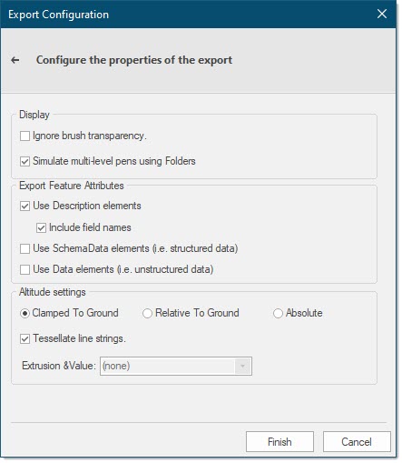
The Export Configuration dialog allows you to configure export options including display settings, attributes and altitude settings.
| Option | Description | |
|
Ignore brush transparency |
Check this tickbox to ignore the transparency setting and export the file with a brush transparency value of 0. |
|
|
Simulate multi-level pens using Folders |
Check this tickbox to store each of the levels of a multi-line pen individually in Google Earth. This allows any of the individual pen levels to be turned on or off. |
|
|
Use Description elements |
Check this tickbox to include only the Description element names (as in the Schema). |
|
|
Include field names |
Check this tickbox to include the field names for each of the Description elements. |
|
|
Use SchemaData elements (i.e. structured data) |
Check this tickbox to maintain the data type in the Exported file. Google Earth does not use this "typed" information but it could be required if the exported file is to be used by other applications. |
|
|
Use Data elements (i.e. unstructured data) |
Check this tickbox if it is not necessary for the data type information to be preserved in the exported file. |
|
|
Altitude settings Clamped To Ground /Relative To Ground /Absolute |
Click the appropriate radio button to determine how the Z values are to be handled. |
|
|
Tessellate line strings |
Check this tickbox to add points along the Linestring to make it follow the terrain. This function is intended for use with the Clamped To Ground option and is not generally used with the |
|
|
Extrusion &Value |
This function is available when Relative To Ground or Absolute are selected. Select a Height column from the drop-down box that contains a value for each object in the overlay to be used as an altitude to extrude the object into a 3D view. |
|
Click Finish to generate the output KMZ file.
The complete specification for OGC KML can be found at: http://www.opengeospatial.org/standards/kml/ 
Example of KMZ output
Make sure the Coordinate Reference System is set to Latitude/Longitude.OGC.WGS_1984.
This example shows how the output KMZ will be displayed when opened in Google Earth.
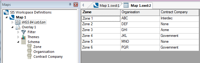
The selected overlay, Overlay 1 in SIS:
The overlay is exported to a .kmz file, in this example Country A.kmz.
Opened in Google Earth the tree would be as shown:
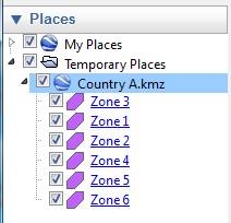
The values in the tree come from the first value in the schema for the overlay being exported.
Arguments to Export API Method
- clsExport$
KMZExporter
Compatibility:
- Cadcorp SIS Desktop
- Cadcorp SIS ActiveX Modeller
- Cadcorp SIS ActiveX Manager
- Cadcorp SIS ActiveX Viewer
- Cadcorp GeognoSIS
