Decorated URLs
You can now open a map view quickly and directly without using SIS WebMap tools or menus. To do this, customise or “decorate” a URL in the browser’s address bar.
For example, adding geolocate=true to the URL:
http://localhost/SISWebMap9/map.aspx?geolocate=true
will enable geolocation and open SIS WebMap at your current location.
Here are some additional parameters that can be added to the URL. Remember all parameters are case-sensitive.
| Additional parameter | SIS WebMap opens |
|
geolocate=true |
current location |
|
x=545352&y=258359 resolution=100 |
Opens at specific location (x, y coordinates) or a specific resolution |
|
markLocation=True |
Place a marker at the location where the map opens. |
|
baseLayer=[BaseLayerName] |
Open with specified Base Layer in active state. |
|
epsg=27700 |
Change Projection |
|
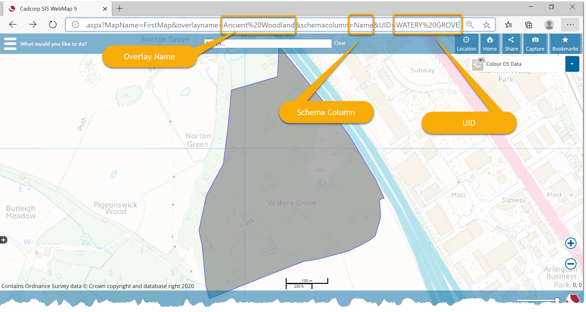
OverlayName=NHS%20Properties schemacolumn=Facility%20Name uid=Guidepost%20Medical%20Group |
Conduct query to open at specific feature |
|
datalayers=[OverlayName] |
Open with Data Layer visible. You can use multiple overlays inside this parameter. Simply separate each overlay using commas and use ASCII characters ("%20" for space and "%2C" for commas) E.g. the list datalayers="overlay 1, overlay2" becomes datalayers="overlay%20one%2Coverlay%202" |
Here is an illustration of a decorated URL that queries for a feature.
Additional Parameters to open WebMap on specific dialogs
A decorated URL can also be used to launch SIS WebMap with the window open at the desired menu options.
For example, adding initialDialog=layersDialog to the URL like this:
http://localhost/SISWebMap9/map.aspx?initialDialog=layersDialog
will open SIS WebMap with an active Map Features dialog window.
The dialog parameters are applicable for other WebMap add-ins as well (EditIT or FindIT).
| Additional parameter | SIS WebMap opens |
|
geolocate=true |
current location |
|
initialDialog=layersDialog |
Map Features dialog |
|
initialDialog=searchByAreaDialog |
Search By Area dialog |
|
initialDialog=measureDialog |
Measure dialog |
|
initialDialog=drawingDialog |
Draw dialog |
|
initialDialog=localKnowledgeDialog |
Local Knowledge dialog |
|
initialDialog=reportDialog |
ReportIT dialog |
|
initialDialog=zoomToCoordinateDialog |
Zoom to Coordinates dialog |
|
initialDialog=settingsDialog |
Settings dialog |
|
datalayers=[OverlayName] |
Open with Data Layer visible. You can use multiple overlays inside this parameter. Simply separate each overlay using commas and use ASCII characters ("%20" for space and "%2C" for commas) E.g. the list datalayers="overlay 1, overlay2" becomes datalayers="overlay%20one%2Coverlay%202" |
URL Defined
By adding coordinates to the end of the site URL you can define the initial location of the map.
For a UK map using British National Grid Coordinates the following example displays an initial location of Cambridge with X and Y defining the exact co-ordinates.
http://localhost or [IPAddress/NameOfServer]/SISWebMap9/map.aspx?x=545352&y=258359
Decorated URLs can be easily shared with the rest of your team or on social media. See also Sharing