GeognoSIS SWD
This is the recommended method of adding data layers to your map.
- Creates a more dynamic connection between layers and map.
- Edit the data in the SWD and see changes instantly updated on your site.
Note: Base layers cannot be added using the GeognoSIS SWD.
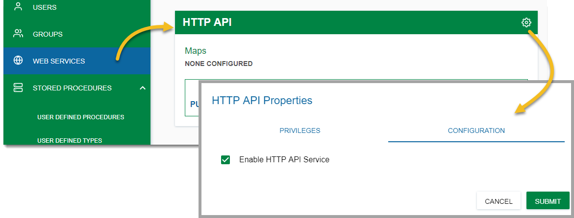
Before adding a GeognoSIS SWD layer, remember to enable GeognoSIS API for your GeognoSIS instance.
- To do this, open GeognoSIS manager and click View > Web Services for your chosen instance.
- Select HTTP API > Configuration and tick the Enable HTTP API Service checkbox.
Adding the data
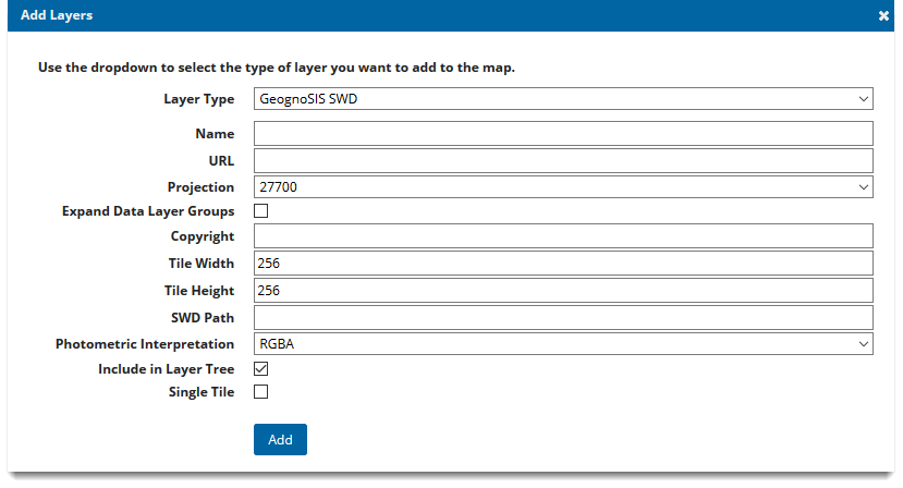
| Field | Is it Optional or Required? |
Description |
|
Name |
Required |
An appropriate name that is descriptive of the layer. |
|
URL |
Required |
URL to the GeognoSIS Instance: |
|
Projection |
Required |
Choose from a supplied list of SRID numbers to determine the data’s projection. More SRID numbers can be added in the Projections table of the webMapLayersConfig.db. |
|
Expand Data Layer Groups |
Optional |
Any data layers grouped together will be initially expanded in the Map Features. |
|
Copyright |
Optional |
Information entered here will appear on the bottom left of your site. |
|
Tile Width |
Required |
Data requests from GeognoSIS are returned in tiles. Use this option to control the tile width (measured in number of pixels). It is set to 256 as default. |
|
Tile Height |
Required |
Datasets from GeognoSIS are returned in tiles. Use this option to control the tile height (measured in number of pixels). It is set to 256 as default. |
|
SWD Path |
Required |
Data needs to be stored on the same machine as your GeognoSIS instance. Type in the local folder address of the SWD (eg C:\Docs\Edit.swd) |
|
Photometric Interpretation |
Required |
The colour interpretation of the data. This can be RGB (Red, Green Blue) or RGBA (Red, Green Blue, Alpha) which takes into account opacity. |
|
Include in Layer Tree |
Optional |
Optional for mobile site. Unlike the desktop site, the mobile site does not have a base layer picker. As a workaround, this option adds the base layer to the Map Features in the main menu, allowing you to switch between base maps. |
|
Single Tile |
Optional |
Check this tickbox to draw a single image for the map. |