GeognoSIS Tile Service
A GeognoSIS Tile Service is a Cadcorp Tile Cache served by GeognoSIS.
When map tiles are loaded initially, they are cached and stored in the TileCache folder of the GeognoSIS installation folder.
Tiles from this cache are served to all new users to save time and bandwidth.
Select GeognoSIS Tile Service in the Layer Type drop-down box and give the overlay an appropriate name.

|
Field |
Is it Optional |
Description |
|
Name |
Required |
Display name for the layer. |
|
Visible |
Required |
Check this tickbox to turn the layer visible. |
|
URL |
Required |
The URL connection to the Cadcorp GeognoSIS instance e.g.,http://server.domain:4326/tileservice/tile.exe |
|
Copyright Text |
Optional |
Text entered here will appear across the bottom left of your Cadcorp SIS WebMap site. |
|
Layer |
Required |
The Layer you wish to add from the Tile Service. |
|
Is Base Layer |
Required |
Designate this as a Base Layer. |
|
Include in Layer Tree |
Optional |
Allows you to switch between base layers in the Map Features dialog. (Only for desktop versions) |
|
EPSG Code |
Required |
The EPSG code the tile cache was created in. |
|
Image Format |
Required |
Image format the tile cache was created in. |
|
Factor |
Required |
The multiplier value applied to the initial value to define the levels, according to the increment value. |
|
Increment |
Required |
Combined with the factor and the initial size defines the levels. |
|
Initial Size |
Required |
Helps define the highest resolution. This value is in CRS units (i.e. for OSGB it is metres and for WGS84 it is degrees). |
|
Origin X |
Required |
The x coordinate of the origin (as defined when the tile cache was built). |
|
Origin Y |
Required |
The y coordinate of the origin (as defined when the tile cache was built). |
|
Tile Width |
Required |
The width of the tiles to be displayed (as defined when the cache was built). |
|
Tile Height |
Required | The height of the tiles to be displayed (as defined when the cache was built). |
|
Transition Effect |
Required |
This is set by default to Resize. This means when zooming into a map, the cached tile is resized and displayed immediately for user-friendliness. The actual tile is then drawn on top of the resized one as it becomes available. |
|
Buffer |
Required |
Number of extra tiles to load around the map that is displayed on the screen. Having a buffer makes panning smoother but a large buffer will result in a slower map render as it will take longer for all the tile requests to be returned by GeognoSIS. |
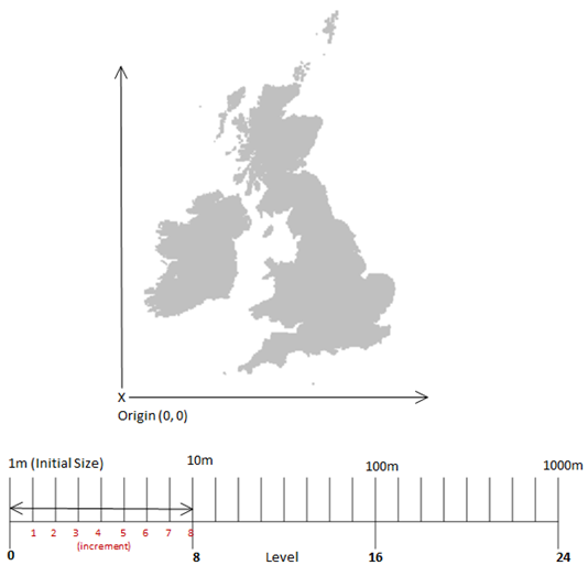
A note on Initial Size, Increment and Factor
The initial size defines the resolution the data uses at level 0.
In the example below it is 1m. Larger values can be selected for the initial size but this will reduce the highest resolution available.
The resolution of subsequent levels is determined by the factor and increment. For every increment increase the resolution is multiplied by the factor.