WMS (OGC Web Map Service)
This allows you to add a single layer from your WMS (unlike WMS from Capabilities which adds all layers being served out by the defined URL).
Note: To use this service your data SHOULD be served out as a WMS. This can be done through GeognoSIS.
After adding the URL, manually add the name of the layer you wish to add using Add Layer. Or use the Get info from capabilities option and select the layer you wish to add.
This will use information in the capabilities document to automatically populate a number of fields.
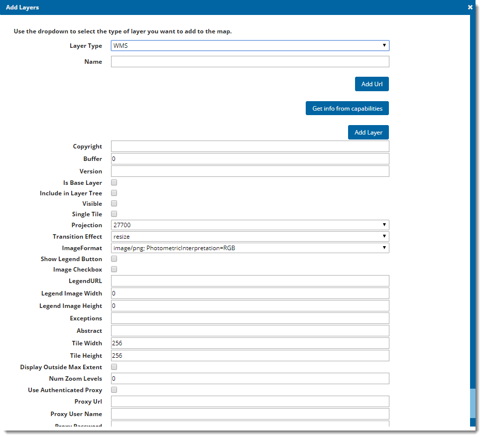
| Field | Is it Optional or Required? |
Description |
|
Layer Type |
Required |
The overlay type selected from the drop-down list. |
|
Name |
Required |
Enter a Name to appear in the More Mapping dialog. |
|
Add URL |
Required |
URL attained from the WMS capabilities document. This can be accessed from the GeognoSIS Manager. |
|
Get info from capabilities |
Optional |
Click this button to display a list of the available layers from the supplied WMS URL. |
|
Add Layer |
Optional You can use this or Get info from capabilities |
If you know the name of the layer, enter it in this field. |
|
Copyright |
Optional |
Text entered here appears on the bottom left of your user site. |
|
Buffer |
Required |
Creates a buffer of tiles outside the visible map frame. By default this value is set to zero. Setting a buffer gives you a smoother experience when panning round the map; however it creates a larger request to the server meaning the server is busier for longer and the site can be slower to load. |
|
Version |
Required |
Automatically populated when you select a layer using Get info from capabilities (if not filled automatically, ensure you add the details manually.) |
|
Is Base Layer |
Optional |
All layers added are assumed to be a data layer unless this box is ticked. |
|
Include in Layer Tree |
If the data is being served out as a base layer and the site accessed on a mobile device, this option allows you to switch between base layers in the Map Features dialog. (The base layer selector on the top right of the site is not included in the mobile version of Cadcorp SIS WebMap). |
|
|
Visible |
Required |
Tick this checkbox for data to appear on the map and in the Map Features dialog. |
|
Single Tile |
Optional |
Tick this checkbox to return the whole map as a single tile. A single tile reduces the number of requests made to the server however it prevents the map from appearing as a slippy map. If you pan around, the whole tile is reloaded for the new location. |
|
Projection |
Required |
A predefined list of SRID numbers that specifies the projection the data will be drawn in. NOTE: More SRID numbers can be added in the Projections table of the webMapLayersConfig.db. |
|
Transition Effect |
Required |
This defines how the map transitions between zoom levels. |
|
Image Format |
Required |
Sets the image format of the served data. |
|
Show Legend Button |
Required |
This is legacy support of Web Map Layers 7.1. Ignore this parameter if using the standard Cadcorp SIS WebMap site. |
|
Image Checkbox |
Ignore |
This is legacy support of Web Map Layers 7.1. Ignore this parameter if using the standard Cadcorp SIS WebMap site. |
|
Legend URL |
Optional |
Add this information manually; this information can be found in the capabilities document in your GeognoSIS Manager. |
|
Legend Image Width |
Optional |
This can be found in the capabilities document in your GeognoSIS Manager. |
|
Legend Image Height |
Optional |
This can be found in the capabilities document in your GeognoSIS Manager. |
|
Exceptions |
Optional |
The format in which an exception is returned. It can be set to INIMAGE where the exception message is displayed in the image or BLANK so that no image is returned. |
|
Abstract |
Optional |
Text entered here appears as metadata next to the layer on your Cadcorp SIS WebMap site. |
|
Tile Width |
Optional |
If not using the single tile option, data requests from GeognoSIS will be returned in tiles. This value refers to the tile width (measured in number of pixels). The width is set to 256 as default. |
|
Tile Height |
Optional |
If not using the single tile option, data requests from GeognoSIS will be returned in tiles. This value refers to the tile height (measured in number of pixels). The width is set to 256 as default. |
|
Display Outside Max Extent |
Optional |
Displays data even if it is outside the maximum extents set for the map. |
|
Num Zoom Levels |
Ignore |
This property can currently be ignored. |
|
Use Authenticated Proxy |
Optional |
Tick this checkbox if your WMS is accessed through an Authenticated Proxy server. |
|
Proxy Url |
Optional |
If using an Authenticated Proxy specify the URL here. {MachineName}/Webmaplayers8/AuthenticatedTileCacheHandler.axd. MachineName may be localhost. |
|
Proxy User Name |
Optional |
Enter User Name of the Authenticated Proxy. |
|
Proxy Password |
Optional |
Enter Password for the Authenticated Proxy. |