WMTS (OGC Web Map Tile Service)
A Web Map Tile Service (WMTS) is an Open Geospatial Consortium (OGC) standard protocol for serving pre-rendered georeferenced map tiles over the Internet.
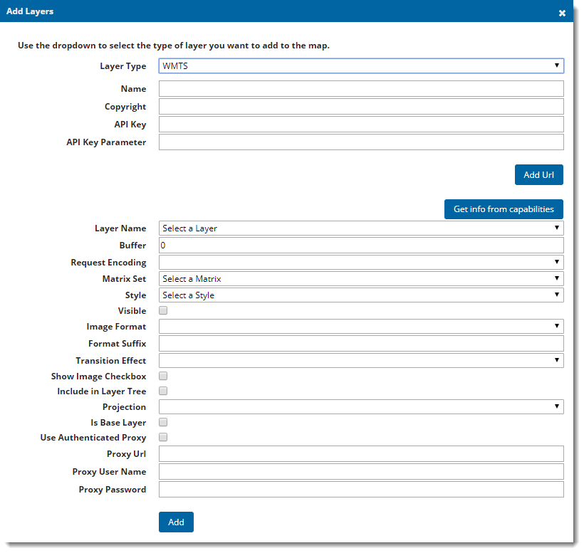
A WMTS can be created by serving out an SWD through GeognoSIS. To add a Geoserver WMTS layer in Cadcorp SIS WebMap, ensure you define a "Default" style in Geoserver.
Adding the data
| Field | Is it Optional or Required? |
Description |
|
Layer Type |
Required |
The overlay type selected from the drop-down list. |
|
Name |
Required |
An appropriate user added name. |
|
Copyright |
Ignore |
Any text entered here will appear on the bottom left of your site. |
|
Add URL |
Required |
The URL to the WMTS, if it is being served out by GeognoSIS this can be found in the capabilities document. |
|
API Key |
Required |
If WMTS layer authentication is required enter your API Key. |
| API Key Parameter | Required |
If WMTS layer authentication is required enter the API Key query parameter. |
|
Get info from capabilities |
Required |
Select this button to populate the dropdown options with information stored in the WMTS capabilities document. |
|
Layer Name |
Required |
This dropdown will be populated from the information stored in the capabilities document. Choose a layer from the ones listed. |
|
Buffer |
Required |
Creates a buffer of tiles outside the visible map frame. This gives you a smoother experience for panning around the map; however it creates a larger request to the server meaning the server is busier for longer and the site can be slower to load. |
|
Request Encoding |
Required |
Found in capabilities document. |
|
Matrix Set |
Required |
Select from one of the matrix set identifiers. |
|
Style |
Required |
Select an option from the dropdown list, this list will be populated when you click Get info from capabilities. |
|
Visible |
This option is not yet available in Cadcorp SIS WebMap but has been added in preparation for future development. |
|
|
Image Format |
Required |
Select the output image format you wish the tile service to create the tiles in. |
|
Format Suffix |
Required |
The suffix of the image format, for example; png, jpeg, gif, bmp. |
|
Transition Effect |
Required |
This defines how the map transitions between zoom levels. Currently there is only one option of resize, this resamples the current tile and displays it stretched or compressed until the new tile is available. |
|
Show Image Checkbox |
Ignore |
This option is present for legacy support of Web Map Layers 7.1, if using the standard Cadcorp SIS WebMap site this parameter can be ignored. |
|
Include in Layer Tree |
Optional |
If the data is being served out as a base layer and the site will be accessed on a mobile device, this option allows you to switch between base layers in the Map Features dialog. (The base layer selector on the top right of the site is not included in the mobile version of Cadcorp SIS WebMap). |
|
Projection |
Required |
Choose from a predefined list of SRID numbers to define what projection the cache will be drawn in. More SRID numbers can be added in the Projections table of the webMapLayersConfig.db. |
|
Is Base Layer |
Required |
This should always be ticked. It defines the layer as a base layer. |
|
Use Authenticated Proxy |
Optional |
Tick this box if your WMTS is accessed through an Authenticated Proxy server. |
|
Proxy Url |
Optional |
If using an Authenticated Proxy specify the URL here. |
|
Proxy User Name |
Optional |
If using an Authenticated Proxy specify the User Name here. |
|
Proxy Password |
Optional |
If using an Authenticated Proxy specify the Password here. |