Cluster/Disperse - Cluster category (Process operations)

Clusters Items based on attribute values
Expression*
The cluster value as a simple property name or as an expression, eg '_FC&' or 'building_type$="industrial"'
Clusters Items based on distance between Items.
Radius*
The cluster radius as a simple property name or as an expression, eg '12.34' or 'Max(123.4,range#)'
-initial overlay.png)
The above image shows an initial Overlay with Polygon Items. The following images show the effect that may be obtained using Cluster Items (by distance) with increasing Radius values:
-all.png)
Clusters Items based on attribute values
Expression*
The cluster value as a simple property name or as an expression, eg '_FC&' or 'building_type$="industrial"'
Clusters Items together that lie within the same Polygon from another Overlay.
| Property | Value | |
|
Filter expression |
A filter expression, eg '_FC& IN (1,2,3)' or 'building_type$="industrial"', to use when finding the cluster Polygons |
|
| Overlay* |
The name of the Overlay containing the cluster Polygons |
|
Creates a cluster point from Items using the DBSCAN (Density-based spatial clustering of applications with noise) algorithm
| Property | Value | |
| Minimum number of items | The minimum number of nearby Items (the ‘density’) required to classify a cluster point, as a simple property name, or as an expression, eg ‘5‘ or‘densitv&‘ | |
| Radius | The cluster radius, as a simple property name, or as an expression, eg ‘12.34’ or 'Max(123.4.range#)' | |
Creates a cluster point from Items based on distance between Items
Radius*
The cluster radius as a simple property name or as an expression, eg '12.34' or 'Max(123.4,range#)'
-initial overlay.png)
The above image shows an initial Overlay with Polygon Items.
The following images show the effect that may be obtained using Create cluster point (by distance) with increasing Radius values.
Note: The Point Items are shown as red crosses, the Polygons are shown to indicate the position of the Point Items.
-all.png)
Creates a cluster point from Items based on attribute values
Expression*: The cluster value, as a simple property name, or as an expression, eg '_FC&' or 'building_type$="industrial"'
Creates a cluster point from Items within regular, rectangular grid cells.
| Property | Value | |
| Cell height* | The height of a cluster grid cell as a simple value, or as an expression, eg '12.34', or '_sx#/12' | |
| Cell width* | The width of a cluster grid cell as a simple value, or as an expression, eg '43.21', or '_sx#/34' | |
|
Origin X |
The X coordinate of the origin of the cluster grid, as a simple value, or as an expression, eg '12.34', or '_ox#' | |
|
Origin Y |
The Y coordinate of the origin of the cluster grid, as a simple value, or as an expression, eg '43.21', or '_oy#' | |
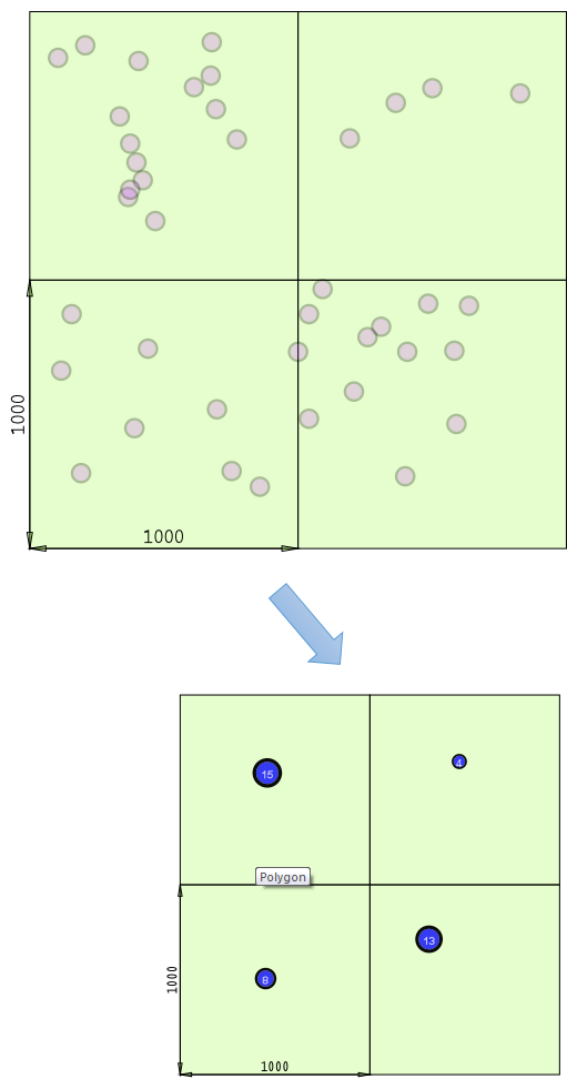
This function aggregates items within a grid of a user-defined size. Items found within a grid cell are represented in the output by a point item with an attribute that shows the sum of the items it represents.
Examples of use may include aggregating data for use at lower scales where exact geographic location is less important than knowing how many items there are.
This example shows the result of the Create cluster point (by grid) function:
Creates a cluster point from Items that lie within the same Polygon from another Overlay.
| Property | Value | |
| Filter expression | A filter expression, eg '_FC& IN (1,2,3)' or 'building_type$="industrial"', to use when finding the cluster Polygons | |
| Overlay* | The name of the Overlay containing the cluster Polygons | |
Sets a cluster label property on each item using the DBSCAN (Density-based spatial clustering of applications with noise) algorithm.
| Property | Value | |
| Minimum number of items | The minimum number of nearby Items (the ‘density’) required to classify a cluster point, as a simple property name, or as an expression, eg ‘5‘ or‘densitv&‘ | |
| Radius | The cluster radius, as a simple property name, or as an expression, eg ‘12.34’ or 'Max(123.4.range#)' | |