Create an Overlay Property
WebMap uses SWD overlay Properties in different scenarios (for instance: using the overlay in certain services or defining specific parameters for a Local Knowledge query).
Remember to set these Properties in Cadcorp SIS Desktop so they can be accessed inside WebMap.
To do this:
- Open the SWD file inside SIS Desktop.
- Right click on the overlay in the tree view and select Properties:
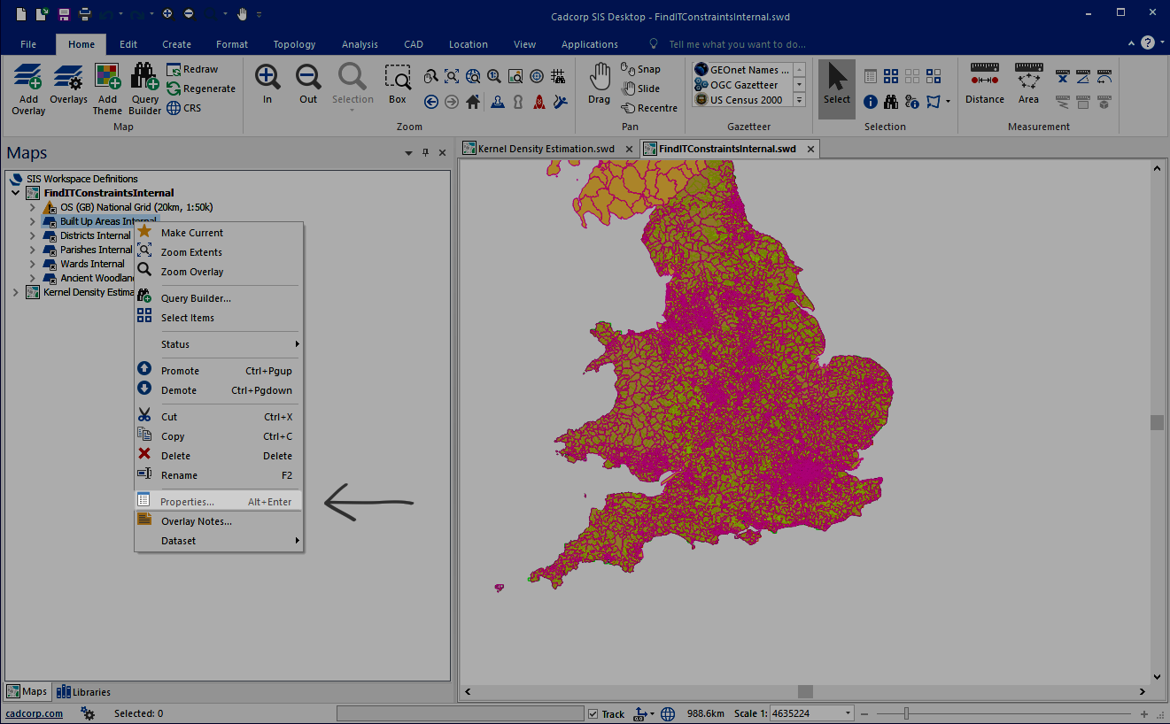
-
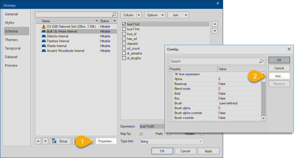
Select Properties again and click Add to add a new property:
| Property | Description | Value |
| WML::Ignore& | Hides overlay so it is not visible in Map Features of a user map. This property is used when printing to PDF. See Setting up the SWD to enable PDF printing. | 1 = True |
| WML::IgnoreHittable& | Hides overlay so it does not appear in Map Features of a user map. However user can still see data in the map window and features can be interrogated for their attributes. | 1 = True |
| WML::Knowledge_Type$ | Defines the type of Local Knowledge query the overlay will be used in. | area, statistic, nearestN,distance |
| WML::Knowledge_AdditionalInfo$ | Runs an if query on the result of a Local Knowledge Statistic query. | A valid Iif statement |
| WML::Knowledge_SearchDistance# | Used in a Local Knowledge distance query to define a search radius. | Search distance in current units |
| WML::Knowledge_Expression$ | Used in a Local Knowledge Statistic query to define the overlay column on which the expression will be executed. | e.g. Incident_Count# |
| WML::Knowledge_Operation$ | Sets the mathematical operation to be carried out for a Local Knowledge Statistic query. | OP_Skewness - Reduces any positive or negative skewing of the results. OP_Variance - The average of the squared differences from the Mean value. OP_Stddev - (Standard Deviation) a measure of the spread of the results. OP_Max - The maximum result value. OP_Mode - The number which appears most often in the results. OP_Median - The middle number in the list of results. OP_Mean - The average of the results. OP_Min - The minimum result value. OP_Sum - The sum of the results. OP_Count - The number of results. |
|
WML::Knowledge_Test$ |
Used in a Local Knowledge Statistic query to define the spatial relationship between the data and the search area for the resultant statistic. |
Available Values ST_Contains - Does the data intersect with the search area? |
| WML::Knowledge_Filter$ |
Filter expression. |
|
| WML::Attribution$ |
Used to set the copyright value on GeognoSIS SWD layers only. |
Free text. |
|
WML::Knowledge_nItems& |
Used in a Local knowledge NearestN query to define the number of items you want to return. | Number of items to be returned (integer). |
Allow query results table to be downloaded to a csv file. This works in conjunction with the Query property below. This property also controls the visibility of the CAPTURE button  in the Table Window. in the Table Window.WML::QueryEnabled@ can be set to true (overlay will be created) and WML::AllowTableExport& = 0 (overlay is created but no attribute results are returned). |
0 = Table view disallowed. 1 = Table view allowed. EXPORT (to csv) and CAPTURE (to png) are disabled. 2 = Table view allowed. EXPORT (to csv) and CAPTURE (to png) are enabled. |
|
| WML::AllowVectorExport@ | Allow layers to be exported to GeoJSON. The Drawing Layer is automatically enabled for vector export. | 1 = True |
| WML::UseVector@ | Boolean type. Set to True to use WML::VectorStyle$ property | 1 = True |
| WML::VectorStyle$ | The value is a JSON object with the style to be applied for the highlight | Example used in Sample SWD, on Ancient Woodland Overlay: {"fill":{"colour":{"r":0,"g":128,"b":0,"a":0.6}},"stroke":{"colour":{"r":0,"g":0,"b":0,"a":1},"width":2}} |
| WML::GeometryOptions$ | JSON string which defines settings for the editable layer. The geometry type for the overlay should be set to polygon using "geometryType": "Polygon" NOTE – Use a capital P when defining Polygon. |
For Example: {"icon": "mdi-shape-polygon-plus","geometryType": "Polygon","textKey": "Polygon","displayColumn": "AString"} |
| WML::AllowWebEditing@ | Determines if a layer is editable. Boolean Type and must be set to True. | 1 = True |
| WML::RefreshInterval& | Refreshes live location data at regular set intervals. Can be used on spatial data, datasets (e.g. View Points) and other data types. | Number of seconds between each refresh. (Long integer) |
| WML::QueryEnabled@ | Determines if a layer can be queried. Boolean Type set to True. | 1 = True |
| WML::MaxStatus& | Sets the overlay status for WebMap. If this property is undefined, a default value of 2 (hittable) is assumed. Ensure the status of the overlay matches the property in the SWD and the value is at least 1. |
0 = Invisible
1 = Visible 2 = Hittable 3 = Editable |
Updated Properties in WebMap v9.1
There are minor changes to a few properties in WebMap v9.1. The layer property name or value (or both) may be different to v9 usage but the nature of the property remains unchanged.
WML::AllowEdit& is now WML::AllowWebEditing@
WML::SearchEnabled& is now WML::QueryEnabled@
WML::DownloadEnabled& is now WML::AllowTableExport&
WML::VisibleOnly& is now WML::MaxStatus&