Set up GeognoSIS to work with Cadcorp SIS WebMap 9.1
WebMap uses GeognoSIS for two data connections:
- Base overlays: These provide background mapping (eg national mapping or aerial photography).
 Related Topics
 - Data Layers: These are defined in a SIS Workspace Definition (SWD). The SWD is consumed by GeognoSIS which then allows it to be published and accessed by WebMap.Related Topics
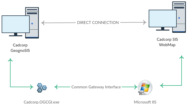
There are two ways in which WebMap can connect to GeognoSIS :
- Using a direct connection (or)
- Using the OGC Common Gateway Interface (CGI).
1. Direct Connection
This option is ready to be used immediately. Ensure data has been loaded into GeognoSIS and the instance is running. Use the following addresses for a direct connection:
| WMS |
| http://server.domain:4326/GeognoSIS/<version>/Services/OGC/WMS.app or http://[IP_address] : [port number] /OgcService/WMS.app / /GeognoSIS/<version>/Services/OGC/WMTS.app etc. and for those services supporting REST: /GeognoSIS/<version>/Services/OGC/WMTS/<version>/... etc. |
Note: This address can be found within the GeognoSIS Manager under Machines > Machine name > GeognoSIS > Web Services > OGC Services > OGC Web Map Service > Capabilities Document.
| WFS |
| http://server.domain:4326/GeognoSIS/<version>/Services/OGC/WFS.app or http://[IP_address] : [port number] /GeognoSIS/<version>/Services/OGC/WFS.app |
Note: This address can be found within the GeognoSIS Manager under Machines > Machine name > GeognoSIS > Web Services > OGC Services > OGC Web Feature Service > Capabilities Document.
| WMTS |
| http://server.domain:4326/GeognoSIS/<version>/Services/OGC/WMTS.app or http://[IP_address] : [port number] /GeognoSIS/<version>/Services/OGC/WMTS.app |
Note: This address can be found within the GeognoSIS Manager under Machines > Machine name > GeognoSIS > Web Services > OGC Services > OGC Web Map Tile Service > Capabilities Document.
| Tile Service |
| http://server.domain:4326/TileService/GetTile or http://[IP_address]:[port number]/TileService/GetTile |