button (WW).gif) Properties... (SWD) Properties... (SWD)
Properties... (SWD) Properties... (SWD)
.png)
or press Alt+Enter on the keyboard.
Properties... displays and allows editing of the properties of the SIS Workspace Definition.
The SIS Workspace Definition dialog will be displayed showing the SWD Property values:
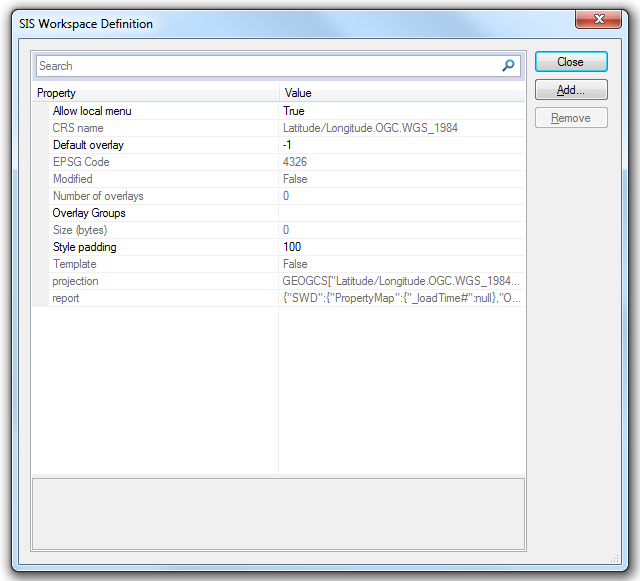
Allow local menu: _bPopupMenu&
Allows the Map Window local menus to function. Defaults to True can be set to False in the drop-down menu at the right-hand end of the row.
CRS name
The matching CRS object name, or default description.
Default Overlay: _nDefaultOverlay&
The currently active Overlay number(starting at 0).
EPSG Code
The matching EPSG code, if any.
Modified: _bModified&
Will show as False if SWD has not been modified since opening.
Will show as True if SWD has been modified since opening.
Number of overlays:_nOverlay&
Number of overlays in SWD.
Overlay Groups: _overlayGroups$
Names and details of any overlay groups, i.e.
{"OverlayGroups":[{"Name":"My Overlay Group","Start":0,"End":2},{"Name":"My New Overlay Group","Start":3,"End":5}]}
"Name":
Name of overlay group.
"Start":
First overlay in group.
"End":
Last overlay in group.
"Name":/"Start":/"End": are repeated for each overlay group.
Size (bytes): _size@
Size of the SWD in bytes.
Style padding: _style_pad&
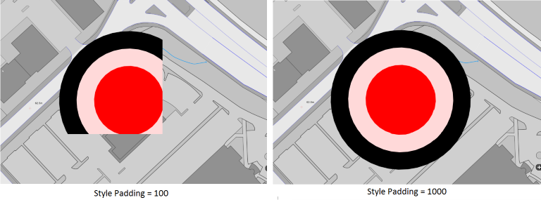
The Style padding value is used with the larger of the width and height of the drawing extents to pad the extents, e.g. to ensure that Point Items that are outside the drawing extents, but whose Symbol overlaps the drawing extents, are drawn correctly. The Style padding value is interpreted as 1/10ths of a percent, e.g. 100 means 10%, the maximum value is 1000 which equates to 100% and translates to three times the maximum of the width and height of the view extents.
The example below shows the possible effects of using a small Style padding value (100) and the maximum value (1000):
Template: _bTemplate&
Will show as False if SWD is not a template.
Will show as True if SWD is a template.
Projection: _projection$
The SWD projection, i.e.
PROJCS["OSGB 1936.British National Grid",GEOGCS["Latitude/Longitude.OGC.OSGB_1936",DATUM["OSGB_1936",SPHEROID["Airy 1830",6377563.396,299.32496460007]],PRIMEM["Greenwich",0],UNIT["degrees",0.0174532925199433]],PROJECTION["Transverse_Mercator"],PARAMETER["Central_Meridian",-2],PARAMETER["False_Easting",400000],PARAMETER["False_Northing",-100000],PARAMETER["Latitude_of_Origin",49],PARAMETER["Scale_Factor",0.9996012717],UNIT["m",1]]
report: _report$
Displays detailed information on SWD load times, i.e.
{"SWD":{"PropertyMap":{"_crs$":"OSGB 1936.British National Grid","_epsg&":27700,"_loadTime#":0.0276703633335084},"Overlays":[{"PropertyMap":{"_name$":"Properties","_nTheme&":1},"Dataset":{"PropertyMap":{"_loadTime#":0.00517400536237055}}},{"PropertyMap":{"_name$":"Road Project"},"Dataset":{"PropertyMap":{"_loadTime#":4.70912973471299e-005}}},{"PropertyMap":{"_name$":"Overlay 1","_nTheme&":1},"Dataset":{"PropertyMap":{"_loadTime#":0.000536116308259632}}}]}}
To add a new attribute to the SWD click the Add... button to display the New Attribute dialog:
![]()
Top of page
Send comments on this topic.
Click to return to www.cadcorp.com
© Copyright 2000-2017 Computer Aided Development Corporation Limited (Cadcorp).