SIS can use databases in a variety of ways:
As storage for graphical items using the OGC SQL92 Database.
To view point data using the View Points dataset.
To view graphical items using the Cadcorp View Geometry dataset.
Only 32-bit SIS and GeognoSIS support the use of Oracle with the following database dataset types:
64-bit SIS and GeognoSIS do not support these database dataset types in Oracle.
A Spatial Database is a database that is optimized to store and query data related to objects in space, including Point, LineString and Polygon items.
Advances in relational database management technology now gives users the option of storing their GIS data in a spatial database rather than using file based storage. SIS is compatible with the following industry-standard spatial databases:
SIS can display non spatial data from various sources. Check with your database administrator to ascertain which database your data is stored in and whether the appropriate database connectivity software has been loaded onto your client. Data can be read from the following sources:
Data is read from the source in its entirety which means the bigger the source data the longer it takes to read data into SIS.
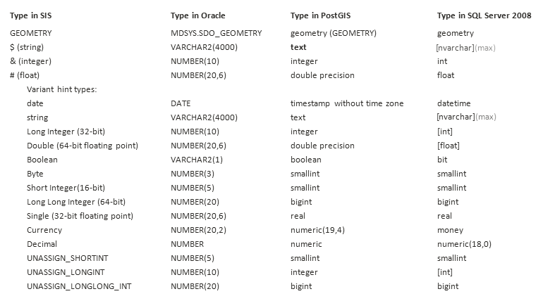
The following table lists the datatypes that are created in each database when data is exported from SIS or when a new column is added to a database overlay.
The listed data types are the ones that should be used when creating tables manually in the database.
Send comments on this topic.
Click to return to www.cadcorp.com
© Copyright 2000-2017 Computer Aided Development Corporation Limited (Cadcorp).