 OGC WMTS OGC WMTS
Location: Overlay Types dialog > OGC > OGC WMTS
Acts as an OGC Web Map Tile Service (WMTS) client, downloading raster images over the Internet from an OGC WMTS.
Selecting OGC WMTS will display the following OGC Web Map Tile Services (WMTS) dialog:

Address of WMTS server
The address can be copied in from the GeognoSIS WMTS Capabilities Document. For example:
http://CSUPP951.cadcorp.net:4330/OgcService/WMTS.impl?
Well-known servers
List of well-known WMTS servers. The initial server in the list is the Cadcorp GeognoSIS Demonstration Server.
You need to define a "Default" style in Geoserver to be able to add a Geoserver WMTS layer in SIS.
KVP
Key value pair encoding.
REST
RESTful encoding
Connect using SAML 2.0 E.CP Profile
Check this tickbox to make a connection using the OASIS SecurityAssertion Markup Language (SAML) version 2.0.
See http://docs.oasis-open/security/saml/v2.0 for details of (SAML) version 2.0 Profiles.
If this option is selected the Shibboleth Federation Metadata dialog will be displayed.
If this option is NOT selected the OGC WMTS Layers dialog will be displayed, see below.
Validate 'Capabilities' XML from server
The WMTS capabilities document tells clients exactly which layers, styles, extents, image formats, etc. a server supports.
Check this tickbox if you wish the XML returned by the server in this document to be validated.
Capabilities...
Displays the XML capabilities document for the OGC WMTS in the resizable HTML/XML Viewer dialog, for example:
Click OK to return to the OGC Web Map Tile Services (WMTS) dialog.
Click Next.
The two possible dialogs are as follows:
If the Connect using SAML 2.0 ECP Profile option is selected in the OGC Web Map Tile Services (WMTS) dialog then the following Shibboleth Federation Metadata dialog will be displayed:

Enter the URL of the Shibboleth Federation Metadata and click Next.
The Shibboleth Logon Details dialog will be displayed:
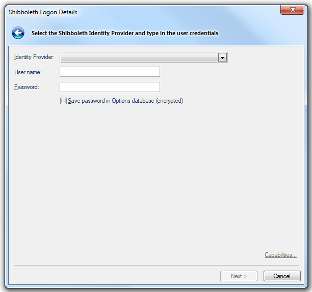
Identity Provider
Select the Identity Provider from the drop-down list.
User name
Type the user ID to use for authentication when you log on.
Password
Type the password to use for authentication when you log on.
Save password in Options database (encrypted)
Should SIS store the password in the Options database? The password will be stored in encrypted form for security.
Click Next.
The following OGC WMTS Layers dialog will be displayed if the Connect using SAML 2.0 ECP Profile option is NOT selected in the OGC Web Map Tile Services (WMTS) dialog.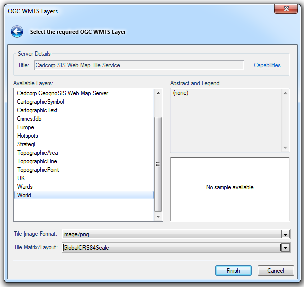
Server Details
Title
This is a descriptive title returned by the OGC WMTS.
Capabilities... displays the capabilities for the OGC WMTS in the resizable HTML/XML Viewer dialog, as shown above.
Click OK on the HTML/XML Viewer dialog to return to the OGC Web Map Tile Services (WMTS) dialog.
Available Layers
Shows the available layers in the OGC WMTS.
Abstract and Legend
Displays extra textual information about the selected OGC WMTS layer, if available. A legend will be displayed in the right-hand pane, if available.
Tile Image Format
This drop-down box selects the format of the images to be downloaded:
image/gif
image/jpeg
image/jpeg: Quality=50
image/jpeg: Quality=75
image/jpeg: Quality=90
image/jpeg: Quality=95
image/png
image/png: PhotometricInterpretation=PaletteColor
image/png: PhotometricInterpretation=RGB
image/png: PhotometricInterpretation=RGBA
image/x-webp
image/x-webp; Quality=50
image/x-webp; Quality=75
image/x-webp; Quality=90
image/x-webp; Quality=95
Tile Matrix/Layout
Choose the required scale set from the drop down box. The above example shows GlobalCRS84Scale, a well known scale set for global cartographic products.
The full list is:
GlobalCRS84Pixel
GlobalCRS84Scale
GoogleMapsCompatible
OSOpenSpaceCompatible
OSOpenSpaceCompatiblePlus
OSOpenSpaceFixedTileSizePlus
Click Finish.
Send comments on this topic.
Click to return to www.cadcorp.com
© Copyright 2000-2017 Computer Aided Development Corporation Limited (Cadcorp).
