Creating an Overlay Property
Web Map Layers 8.0 uses overlay properties for a number of reasons from defining an overlay to be used in certain services to defining certain parameters for use in a Local Knowledge query. A full list of Web Map Layers 8.0 properties is shown at the end of this topic.
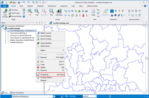
To set an overlay property right click on the overlay in the tree view and select Properties:

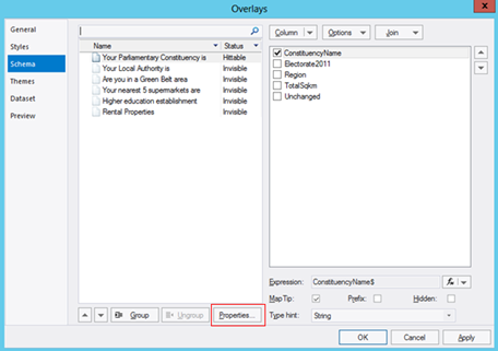
Then select Properties again:

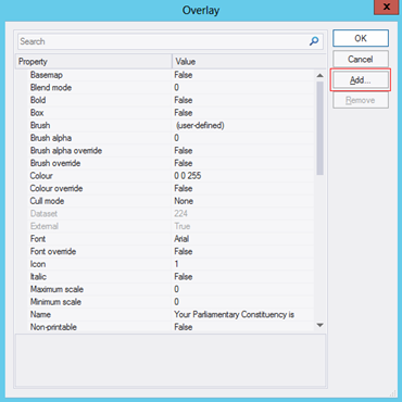
And finally, select Add… to add a new property:

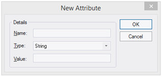
This will then open a New Attribute dialog where you can add the required property and value:

All available properties are defined below:
| Property | Description | Value |
| WML::AllowSnapping& | This property allows the drawing tool to snap to the overlay. Only one overlay can be ‘snappable’ at a time. To use this function snapping needs to be enabled on your Web Map Layers 8.0 site (achieved using the settings button on the top right of your site). | 1 = True |
| WML::SearchEnabled& | This property defines the overlay to be used in the Search by Area service. | 1 = True |
| WML::VisibleOnly& | This property sets the maximum status the overlay can be set to when toggling on and off. |
1 = visible 2 = hittable 3 = editable |
| WML::DownloadEnabled& | This property allows the results of a Search by Area to be downloaded for the overlay. | 1 = True |
| WML::Ignore& | This property results in the overlay being hidden, it will not appear in the map features dialog or on your map. This property is used when printing to PDF. See Setting up the SWD to enable PDF printing. | 1 = True |
| WML::IgnoreHittable& | This property results in the overlay NOT being displayed in the list of map features but will display the data in the map window and allows the features to be interrogated for their attributes. | 1 = True |
| WML::Knowledge_Type$ | This property defines which type of Local Knowledge query the overlay will be used in. | area statistic nearestN distance |
| WML::Knowledge_AdditionalInfo$ | This property runs an iif query on the result of a Local Knowledge Statistic query. | A valid Iif statement |
| WML::Knowledge_SearchDistance# | This property is used in a Local Knowledge distance query to define a search radius. | Search distance in current units |
| WML::Knowledge_Expression$ | This property is used in a Local Knowledge Statistic query to define the overlay column on which the expression will be executed. | e.g. Incident_Count# |
| WML::Knowledge_Operation$ | This property sets the mathematical operation to be carried out for a Local Knowledge Statistic query. | OP_Count - The number of results. OP_Sum - The sum of the results. OP_Min - The minimum result value. OP_Mean - The average of the results. OP_Median - The middle number in the list of results. OP_Mode - The number which appears most often in the results. OP_Max - The maximum result value. OP_Stddev - (Standard Deviation) a measure of the spread of the results. OP_Variance - The average of the squared differences from the Mean value. OP_Skewness - Reduces any positive or negative skewing of the results. |
| WML::Knowledge_Test$ | This property is used in a Local Knowledge Statistic query to define the spatial relationship between the data and the search area for the resultant statistic. | ST_Contains - Does the data intersect with the search area? ST_Crosses - Does data cross the search area? ST_Disjoint - Is the data disjointed from the search area? ST_Equals - Is the data equal to the search area? ST_Intersect - Does the data intersect the search area? ST_Overlap - Does the data overlap the search area? ST_Touches - Does the data touch the search area? ST_Within - Is the data within the search area? |
| WML::Knowledge_Filter$ | This property is used to filter the results of a Local Knowledge Query. | Filter expression. |
| WML::Knowledge_nItems& | This property is used in a Local knowledge NearestN query to define the number of items you want to return. | Number of items to be returned (integer). |
| WML::MetadataUUID$ | This property allows information from an INSPIRE metadata record to be viewed within Web Map Layers 8.0. | Metadata record name. |
| WML::HasJoin& | This property is used to support one to many relationships in SIS cursor datasets. | 1 = True |
Send comments on this topic.