OS (GB) MasterMap Topography Layer
A dataset that views OS (GB) MasterMap Topography Layer data stored in any of the relational databases supported by the Cadcorp SIS OS MasterMap Manager: Oracle Locator/Spatial; PostGIS; Microsoft SQL Server Spatial; and Cadcorp OS MasterMap Database (ODB).
Note: OS MasterMap Manager allows data supplied directly from Ordnance Survey to be loaded into SIS without translation and also handle COU updates.
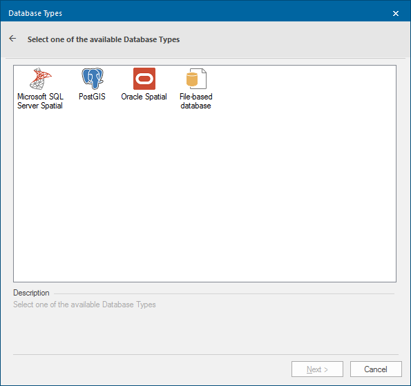
Select OS (GB) MasterMap Topography Layer and click Next to display the Database Types dialog:
Note: These datasets are not editable and only show tables which match the schema created by using the OS MasterMap Manager.
Select the required database. Click Next and complete the connection dialog for the chosen database connection dialog:
Microsoft SQL Server Spatial Dataset
This dataset stores items in a Microsoft SQL Server Spatial database using the planar geometry type. This allows SIS to interoperate with other software that supports the Microsoft SQL Server Spatial database planar geometry type. Click here for the full description of the Microsoft SQL Server Spatial Dataset option.
PostGIS
This dataset stores items in a PostGIS-enabled PostgreSQL database using the PostGIS spatial schema. This allows SIS to interoperate with other software that supports the PostGIS spatial schema.
Click here for the full description of the PostGIS option.
Oracle Spatial
This dataset stores items in an Oracle 9i or later, Spatial database, using the Oracle Object-Relational schema. This allows SIS to interoperate with other software that supports the Oracle Spatial Object-Relational schema. Click here for the full description of the Oracle Spatial option.
File-based database
Reads one of the supported database formats directly from a file, e.g. Microsoft Access .mdb/.accdb, or SQLite .db/sqlite. Click here for the full description of the File-based database option.