Viewshed
Viewshed calculates a 'viewshed' over Grid Items.
Select Analysis > Grids > Viewshed.
A Viewshed is the area that can be seen from a particular 3D location. For example, you could calculate a viewshed to determine how many residents in an area would be able to see a proposed wind generator. SIS Desktop 9.1 can calculate viewsheds for Digital Terrain Models (DTM) or grid items.
To create a viewshed:
- Select a DTM or Grid item.
- Select Viewshed.
- Click the location for the viewpoint in the map window.
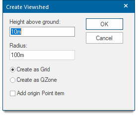
- Complete the Create Viewshed dialog entries as follows:
- Click OK to create the Viewshed item.
| Option | Description | |
| Height above ground | The height above the snapped point from which to calculate the Viewshed. | |
| Radius | The radius of the viewshed. | |
| Create as Grid | The result of the Viewshed calculation will be one Grid item for each of the source Grid items. | |
| Create as QZone | The result of the Viewshed calculation will be a single QZone item. | |
| Add origin Point item | Check the tickbox to create a Point item at the origin of the Viewshed. | |