Restricting the display of items on the overlay
To turn item display on or off, use the filters in the General tab in the Overlays dialog.
Property Filter
Filters displays items on the overlay based on criteria you have chosen. For example you can exclude certain classes of items from the display, or choose to display only selected features, or only those items which have a certain property.
Once applied to an overlay a filter stays in force until you clear it. To clear a filter, use either:
1. Reset command in the Maps Control Bar.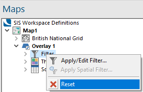
2. Delete button .png) next to Property Filter or Spatial Filter on the General tab of the Overlays dialog.
next to Property Filter or Spatial Filter on the General tab of the Overlays dialog.
Note: To filter by geometrical tests use the Spatial Filter option.
Spatial Filter
You can select a Spatial Filter to use on the overlay. A spatial filter is an item used to carry out a variety of spatial tests. Items on the selected overlay will be displayed only if they pass the spatial filter test.
For instance if the spatial filter were a Polygon item or closed LineString item it could exclude from the display all items which lie outside it; if it were an open LineString item it could display only those items which intersect with it; if it were a point item, it could display only those items which contain it and so on.
Spatial Filters can be used once or stored for later use as named Objects in libraries. Spatial Filters are also used to restrict which items may be selected for editing.
Once you have applied a spatial filter to an overlay it stays in force until you clear it. You can do this on the Include tab of the Overlays dialog or by using the overlay local command Reset in the Maps Control Bar.
Scale thresholds
Each overlay has minimum and maximum scale settings and the overlay is displayed on screen only when the display scale is between these two settings.
Note: See also What is Scale?
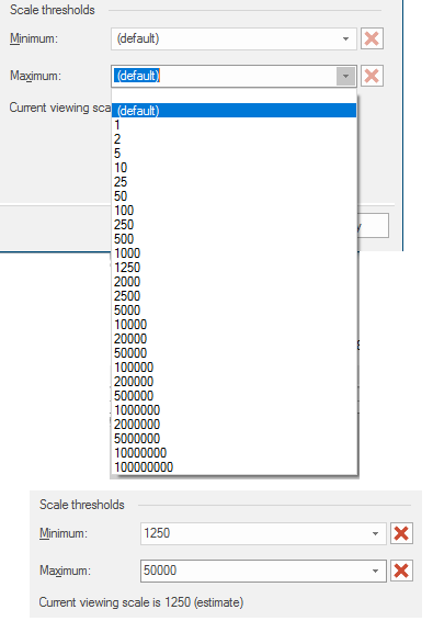
The red cross buttons become active when the Minimum/Maximum values are set.
Click these buttons to return the value to (default).