Grid (Process operations)
Select Create > Process > Grid.

Multiplies the cell resolution of the first grid by the factor specified by an expression.
|
Property |
Value |
|
Expression* |
Enter the required factor as an expression in the text box or in the Expression Builder dialog. |
| Extent type* | The extent type can be Union, First or Intersection. |
| No-data 1 Expression | The expression to be used when no data is found. |
| No-data 2 Expression | The second expression to be used when no data is found. |
| No-data/no-data Value | The value assigned to no-data. |
Creates a Terrain Ruggedness Index map (the average difference in elevation between a Grid cell and each of the surrounding cells) from a Grid.
Creates a Topographic Position Index map (the average difference between the elevation of a Grid cell and the mean of the elevations of each of the surrounding cells) from a Grid.
Creates an Aspect map (the azimuth, or angle, of the slope in a Grid cell) from a Grid.
Properties: The aspect algorithms are: Hom, Zevenbergen & Thorne
Trigonometric*: Should the aspect values be returned as a trigonometric'angle (in degrees anti-clockwise from east/the X axis) instead of an azimuth (in degrees clockwise from north)? True/False.
Creates Contour Polygons from a Grid at fixed intervals.
| Property | Value | |
| 3D* | Should the Polygon Items have their height set to match the contour level? True/False | |
| Interval*: | The interval between contour levels, as a simple value or as an expression (eg ‘100‘ or ‘(_MaxGridVal#-_MinGridVal#)/10‘) | |
| Offset*: | The offset, relative to 0.0. to apply to the fixed interval contour levels as a simple value or as an expression (eg ‘50‘ or 'Max(50._MinGridVal#)') | |
Creates Contour Polygons from a Grid at fixed levels.
| Property | Value | |
| 3D* | Should the Polygon Items have their height set to match the contour level? True/False | |
| Interval*: | The interval between contour levels, as a simple value or as an expression (eg ‘100‘ or ‘(_MaxGridVal#-_MinGridVal#)/10‘) | |
| Offset*: | The offset, relative to 0.0. to apply to the fixed interval contour levels as a simple value or as an expression (eg ‘50‘ or 'Max(50._MinGridVal#)') | |
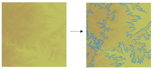
Creates contour LineString Items from a Grid at fixed intervals.
| Property | Value | |
| 3D* | Should the LineString Items have their height set to match the contour level? True/False | |
| Interval*: | The interval between contour levels, as a simple value or as an expression. | |
| Offset*: | The offset, relative to 0.0, to apply to the fixed interval contour levels, as a simple value, or as an expression. | |
Typical contour display:
Creates contour LineString Items from a Grid at fixed levels.
| Property | Value | |
| 3D* | Should the LineString Items have their height set to match the contour level? True/False | |
| Levels* | The contour levels, as a space- or comma-separated list of values or as a 'repeat string' e.g. '100 200 300' or '100 repeat 3'. | |
Typical contour display:
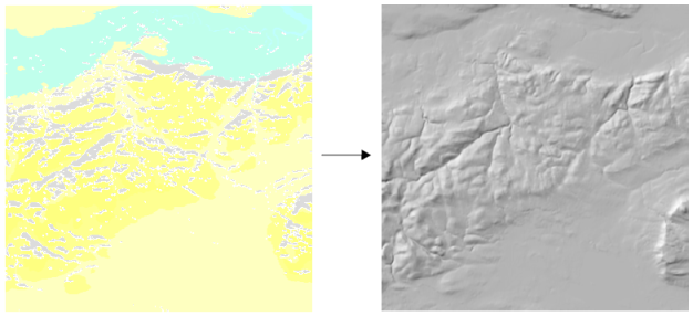
Creates a shaded relief map from a Grid. This process is suited to OS LandForm PANORAMA DTMs.
| Property | Value |
| Algorithm* | The slope and aspect algorithms are: Hom, Zevenbergen & Thorne |
| Altitude* | The altitude of the light, in degrees between 90 (vertical) and 0 (horizontal), as a simple value, or as an expression. |
| Azimuth* | The azimuth of the light, in degrees clockwise from north, as a simple value, or as an expression. |
| Combined* | Should the shaded relief map be created using a combination of slope and oblique shading? True/False. |
| Exaggeration* | The exaggeration factor to apply to vertical values, as a simple value, or as an expression. |
| Z Ratio* | The ratio between the vertical units and the horizontal units, as a simple value, or as an expression. |
Typical Hillshade display:

Explodes a Grid Item into one Point Item per Grid cell.
Set Z: Decide if the 'Z' of the Point Items be set to the Grid cell value (in addition to an Item attribute)? True/False.
Creates a coverage of Polygon Items from a Grid.
3D*: Should the LineString Items have their height set to match the height in the Grid? True/False.
Explodes a Grid Item into one Polygon Item per Grid cell.
Set Z: Should the 'Z' of the Polygon Item vertices be set to the Grid cell value (in addition to an Item attribute)? True/False.
Creates a Roughness map (the largest difference in elevation between a Grid cell and those of the surrounding cells) from a Grid.
Creates a grid from point data using the Barnes interpolation method. Click for more information 
|
Property |
Value |
|
Cell size X* |
Enter the cell size X. |
|
Cell size Y* |
Enter the cell size Y. |
|
Expression |
Add an expression to describe the value to be used in the interpolation |
|
Grid form* |
Choose form the available Grid forms |
|
Grid pixel type* |
The grid pixel type (bit depth) of an image. |
|
Origin X |
Enter the grid origin X. |
|
Origin Y |
Enter the grid origin Y. |
|
Origin Z |
Enter the grid origin Z. |
|
Use no-data values* |
Should the process use grid cells which have no-data (null) values? True/False. |
Creates a grid from point data using the value of the closest point to each feature.
|
Property |
Value |
|
Cell size X* |
Enter the cell size X. |
|
Cell size Y* |
Enter the cell size Y. |
|
Expression |
Add an expression to describe the value to be used in the interpolation |
|
Grid form* |
Choose form the available Grid forms |
|
Grid pixel type* |
The grid pixel type (bit depth) of an image. |
|
Origin X |
Enter the grid origin X. |
|
Origin Y |
Enter the grid origin Y. |
|
Origin Z |
Enter the grid origin Z. |
|
Use no-data values* |
Should the process use grid cells which have no-data (null) values? True/False. |
Creates a grid from point data using the count of features within each grid.
|
Property |
Value |
|
Cell size X* |
Enter the cell size X. |
|
Cell size Y* |
Enter the cell size Y. |
|
Expression |
Add an expression to describe the value to be used in the interpolation |
|
Grid form* |
Choose form the available Grid forms |
|
Grid pixel type* |
The grid pixel type (bit depth) of an image. |
|
Origin X |
Enter the grid origin X. |
|
Origin Y |
Enter the grid origin Y. |
|
Origin Z |
Enter the grid origin Z. |
|
Use no-data values* |
Should the process use grid cells which have no-data (null) values? True/False. |
Creates a grid from point data using interpolation.
|
Property |
Value |
|
Cell size X* |
Enter the cell size X. |
|
Cell size Y* |
Enter the cell size Y. |
|
Expression |
Add an expression to describe the value to be used in the interpolation |
|
Grid form* |
Choose form the available Grid forms |
|
Grid pixel type* |
The grid pixel type (bit depth) of an image. |
|
Origin X |
Enter the grid origin X. |
|
Origin Y |
Enter the grid origin Y. |
|
Origin Z |
Enter the grid origin Z. |
|
Use no-data values* |
Should the process use grid cells which have no-data (null) values? True/False. |
Creates a grid from point data using Inverse Distance Weighting interpolation. Click here  for more information.
|
Property |
Value |
|
Cell size X* |
Enter the cell size X. |
|
Cell size Y* |
Enter the cell size Y. |
|
Expression |
Add an expression to describe the value to be used in the interpolation |
|
Grid form* |
Choose form the available Grid forms |
|
Grid pixel type* |
The grid pixel type (bit depth) of an image. |
|
Origin X |
Enter the grid origin X. |
|
Origin Y |
Enter the grid origin Y. |
|
Origin Z |
Enter the grid origin Z. |
|
Power |
A power value smaller than 2 will cause the interpolated values to be dominated by points further away. |
|
Use no-data values* |
Should the process use grid cells which have no-data (null) values? True/False. |
Creates a grid from point data using the interpolation of the sum of values within a defined grid.
|
Property |
Value |
|
Cell size X* |
Enter the cell size X. |
|
Cell size Y* |
Enter the cell size Y. |
|
Expression |
Add an expression to describe the value to be used in the sum interpolation |
|
Grid form* |
Choose form the available Grid forms |
|
Grid pixel type* |
The grid pixel type (bit depth) of an image. |
|
Origin X |
Enter the grid origin X. |
|
Origin Y |
Enter the grid origin Y. |
|
Origin Z |
Enter the grid origin Z. |
|
Use no-data values* |
Should the process use grid cells which have no-data (null) values? True/False. |
Creates a grid from point data using natural neighbour interpolation which provides a smoother approximation of the results.
|
Property |
Value |
|
Cell size X* |
Enter the cell size X. |
|
Cell size Y* |
Enter the cell size Y. |
|
Expression |
Add an expression to describe the value to be used in the interpolation |
|
Grid form* |
Choose form the available Grid forms |
|
Grid pixel type* |
The grid pixel type (bit depth) of an image. |
|
Origin X |
Enter the grid origin X. |
|
Origin Y |
Enter the grid origin Y. |
|
Origin Z |
Enter the grid origin Z. |
|
Use no-data values* |
Should the process use grid cells which have no-data (null) values? True/False. |
Creates a Slope map (the angle, or percentage, of the slope in a Grid cell) from a Grid.
|
Property |
Value |
|
Algorithm*:
|
The slope algorithm to use- Hom, Zevenbergen & Thorne |
|
Percentage* : |
Should the slope values be returned as a percentage instead of an angle? True/False |
|
Z Ratio* |
The ratio between the vertical units and the horizontal units, as a simple value, or as an expression, eg '2.54' or '57.296*RadiansToMetres#' (the default value is 1.0) |
To divide a grid into smaller cells.
|
Property |
Value |
|
Extent type* |
Choose from Union, First or Intersection extent types. |
|
No-data mode* |
Choose from these 3 modes: 1. No-data cells 2.No-data cells where all grids' input cells are no-data.or 3. No-data cells where any grids' input cell is no-data |
Finds the locations and extents of point clusters in two-dimensional space.
|
Property |
Value |
|
Distance |
Distance band or threshold distance (measured in pixels). |
|
Distance method* |
Select Euclidian or Manhattan distance measure |
|
Grid pixel type* |
Sets the grid pixel type (bit depth) of an image. |
|
Number of neighbours |
Enter the number of neighbours or use the Expression Builder to create an expression. |
|
Relationship* |
Conceptualization of spatial relationship. |
Allows a grid value to be multiplied by a number or expression
Multiplier*: The number to be multiplied by.
Allows a grid value to be added to by a number or expression
Addend*: The number to be added.
Allows a grid value to be subtracted from by a number or expression
Subtrahend*: The number to be subtracted.
Allows a grid value to be divided by a number or expression
Divisor*: The number to be divided by.
Creates a Grid item from the distribution of items using a Kernel Density Estimation (KDE) algorithm.
See also KDE Hot Spot for a full description of the KDE co-parameters.
|
Property |
Value |
|
Bandwidth* |
Sets the Bandwidth (in metres). |
|
Cell size X* |
Sets the X size of the Grid cells in metres. |
|
Cell size Y* |
Sets the Y size of the Grid cells in metres. Cell size is also known as the grid resolution (Resolution property). |
|
Coincident points* |
Allows you to select how overlapping points are treated. See KDE Hot Spot - Coincident Point Calculation. |
|
Expression |
|
|
Grid form* |
Choose from the available grid forms |
|
Grid pixel type* |
Sets the grid pixel type (bit depth) of an image. |
|
Grid type* |
Select the type of Grid to be created. See KDE Hot Spot - Grid type. |
|
Kernel function* |
There are nine different kernel functions to select from to create the Grid item. See KDE Hot Spot - Kernel Function. Allows you to specify the X/Y/Z origins. |
|
Units* |
Select the required units from the drop-down list. |
|
Use no-data values* |
Use no-data values. True/False. |
Comparator*
TBD
|
Property |
Value |
|
Extent type* |
Select from these three extent types: Union, First or Intersection |
|
No-data mode* |
Select from the three available modes |
TBD
Comparator*: TBD
TBD
|
Property |
Value |
|
Extent type* |
Select from these three extent types: Union, First or Intersection |
|
No-data mode* |
Select from the three available modes |
TBD
|
Property |
Value |
|
Extent type* |
Select from these three extent types: Union, First or Intersection |
|
No-data mode* |
Select from the three available modes |
Minuend*
The number from which another number is to be subtracted.
Dividend*
The number to be divided by another number.
Sets the value of all Grid cells that match a comparison against the 'from' value to the 'to' value.
|
Property |
Value |
|
'From' value*: |
The original value to compare as a single value or as an expression, e.g. '123' or '_AverageGridVal# + 2 * _StdDevGridVal#'. |
|
'To' value* |
The new value to use, as a simple value, or as an expression. e.g. '321' or '_NoDataGridVal#'. |
|
Comparison* |
The comparison to use when testing the original value. |
Sets the grid pixel type (bit depth) of an image.
Grid pixel type*: Select the grid pixel type (bit depth) of an image from.
Subtract one grid from another.
|
Property |
Value |
|
Extent type* |
Select from these three extent types: Union, First or Intersection |
|
No-data mode* |
Select from the three available modes |
Add one grid to another.
|
Property |
Value |
|
Extent type* |
Select from these three extent types: Union, First or Intersection |
|
No-data mode* |
Select from the three available modes |
TBD