Set up OGC Services
The Open Geospatial Consortium (OGC) provides simple protocols for:
- Requesting map images from one or more distributed geospatial databases (WMS or the Web Map Service).
- Requesting geographical features independent of platforms (WFS or Web Feature Sevice)
To use them on WebMap, data using these protocols should first be loaded using GeognoSIS Manager.
Note: You can add raw data files and SWDs; however we strongly recommend SWDs as they are configurable and can hold multiple overlays.
WMTS is ideal for for basemapping as this changes less frequently and a cache of tiles is built over time as the WMTS layer is used.
- Set up a new instance on GeognoSIS manager. Click here for more information

- Click Edit.
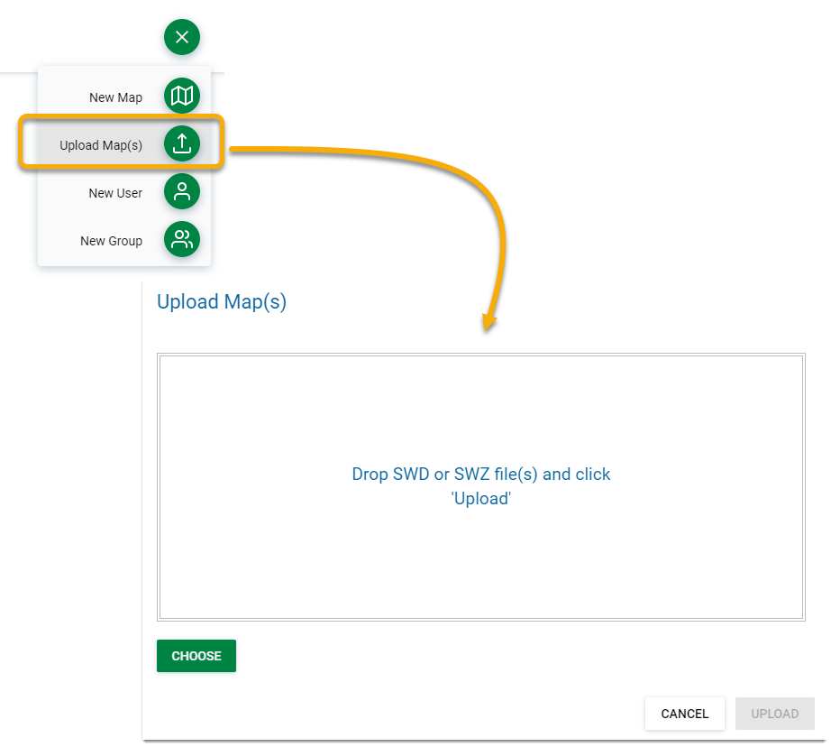
- Click Upload Map from the action button and select your SWD.
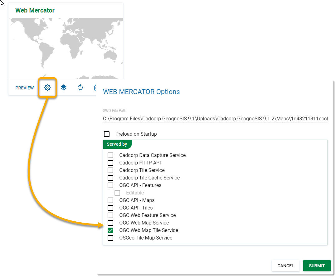
- Once the data file has been loaded, click Options and tick the OGC Web Map Tile Services checkbox.
- Click Submit.
WMS can be used for more dynamic map layer datasets
- Set up a new instance on GeognoSIS manager. Click here for more information
- Click Upload Map and select your SWD.
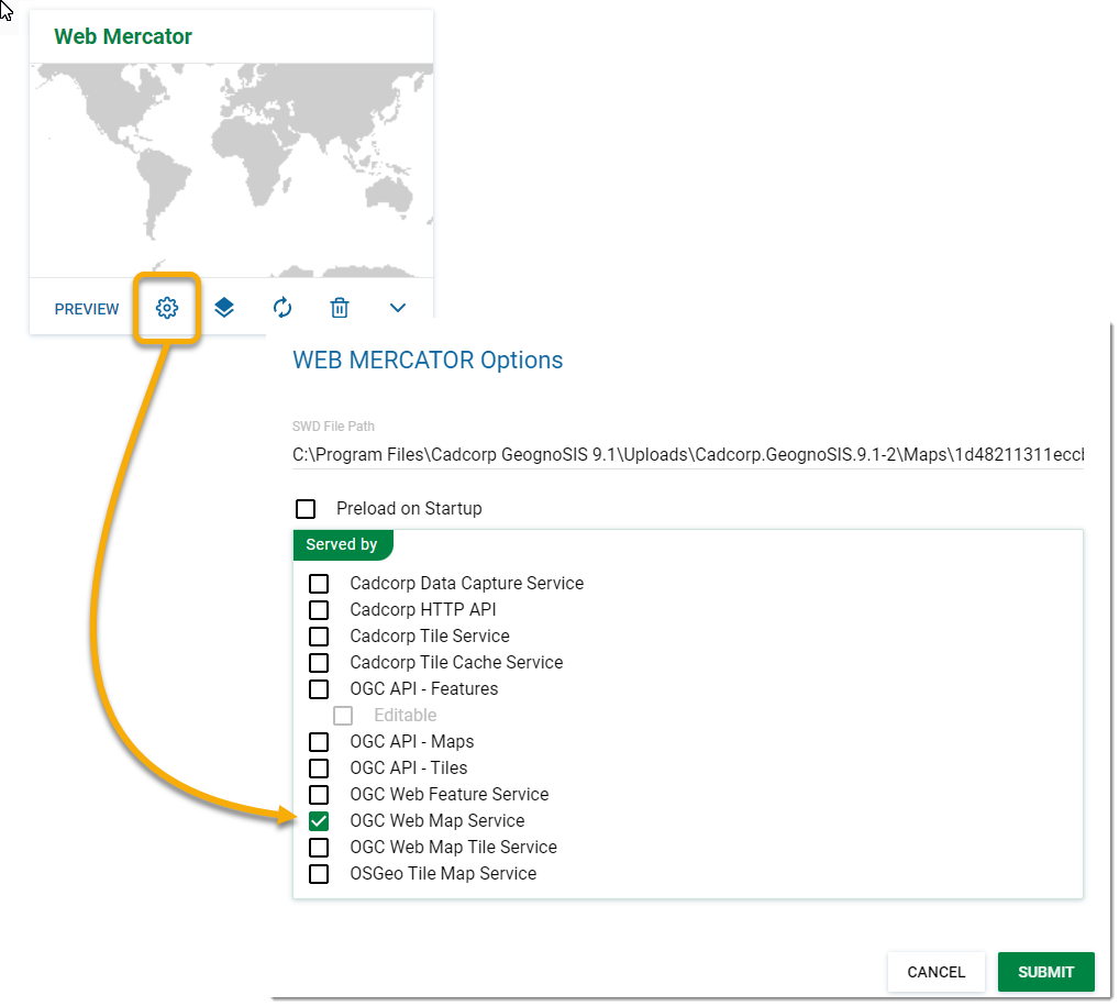
- Once the data file has been loaded, click Options and tick the OGC Web Map Services checkbox.
- Click Submit.
Note: You can use data files instead of SWDs to set up Web Map Services. However you may experience some loss of functionality e.g., scale thresholding.
To view the data files right click on OGC Web Map Service and choose Refresh. To view an individual data file, click Preview on the uploaded map. To view all WMS maps, go to Web Services > OGC > Web Map Service and click the View button.
WFS is particularly handy for small or light datasets.
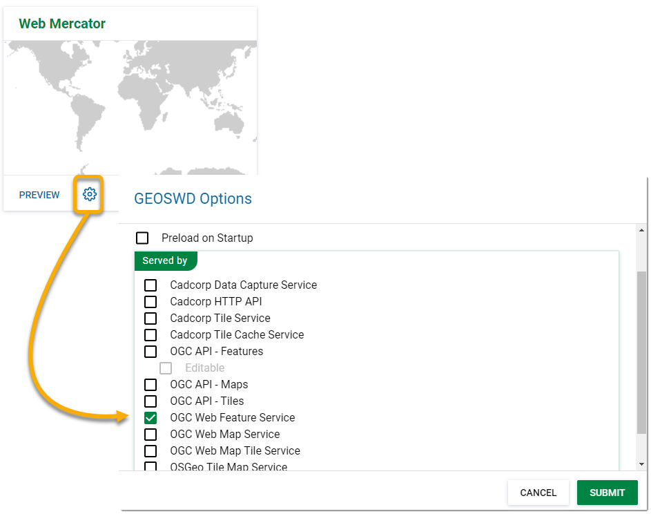
Setting up data to be served out via WFS is similar to setting up a WMS; follow the steps detailed above.
Once you have loaded the data, remember to click Properties and tick the OGC Web Map Services checkbox.
The CGI method directs requests to GeognoSIS through IIS and the OGC CGI executable. The CGI acts as a forwarding service, sending requests to the corresponding impl file.
Crucially this connection allows sending/receiving of AJAX requests. With AJAX requests users can interrogate data and use the Get Feature Information tool effectively.
Setting up the CGI connection
- Copy the Cadcorp.OGC.CGI.exe file (found in the root folder of GeognoSIS: C:\Program Files\Cadcorp GeognoSIS 9) and paste it into a newly created folder within wwwroot folder (C:/inetpub/wwwroot). You can call this folder whatever you wish, but for the purpose of this documentation it will be renamed WME.
- Rename the Cadcorp.OGC.CGI.exe to something simpler like the service name such as wms.exe.
- Within the WME folder create a configuration file called wms.ini (or whatever the .exe file is called). Open this file and add the following information (select only the information below the service you are interested in):
| WMS |
| SIS_SERVER_ADDRESS=http://[machine_name].[domain_name]:4326/ SIS_SERVICE=wms |
| WFS |
| SIS_SERVER_ADDRESS=http://[machine_name].[domain_name]:4326/ SIS_SERVICE=wfs |
| WMTS |
| SIS_SERVER_ADDRESS=http://[machine_name].[domain_name]:4326/ SIS_SERVICE=wmts |
| Tile Service |
| SIS_SERVER_ADDRESS=http://[machine_name].[domain_name]:4326/ SIS_SERVICE=tile |
Note: The address is the address of the GeognoSIS instance and the port number must correspond with the port used by the GeognoSIS Express instance
- Open IIS (Start > Administrative tools > Internet Information Services (IIS) Manager) and expand the site to show the newly created WME folder.
- Right click on the folder and choose Convert to Application and change from 'DefaultAppPool' to 'LayersPoolv8'.
- Still inside IIS, open up Handler Mappings. Add a new script map with the request path '*.exe' and the path to the executable being the wms.exe (or other service name) under the folder you previously created.
- Now click on Edit Feature Permissions and ensure Execute is checked.
- Additional optional settings can be applied to the .ini file if required:
| Key | Value |
| SIS_USER_NAME | The GeognoSIS user account to use |
| SIS_PASSWORD | The password for the GeognoSIS |
| SIS_WS_REQUEST_URL | The web service request URL which will substitute for the GeognoSIS service request address for outside calls. This is the address of the CGI for clients outside the web server.
e.g. http://a.company.com/wms.exe |
| LOOKUP_SERVER_ADDRESS | The name of an environment variable which contains the GeognoSIS service address. |
| LOOKUP_USER_NAME | The name of an environment variable which contains the user name. |
| LOOKUP_PASSWORD | The name of an environment variable which contains the password. |
Once setup is complete, the connection string (URL) will look like this:
| Example URL String |
| http://server.domain/WME/wms.exe or http://[server].[domain_name]/[folder_name]/[service].exe |
Note: If Cadcorp GeognoSIS is installed on the same machine as WebMap, "localhost" can be used in place of "server.domain
For multiple CGI connections to different services each service must have its own EXE file and corresponding ini file.
Ensure the machine on which the OGC.CGI.exe will be hosted has Microsoft Visual C++ 2010 Redistributable Package installed for the appropriate technology.