Location: Overlay Types > Ordnance Survey (GB) > Meridian 2
OS (GB) Meridian 2 is a mid-scale vector product, available from www.ordnancesurvey.co.uk OS OpenDataTM. OS (GB) Meridian 2 uses a number of layers of data, including motorways, A roads, B roads, railways, developed land-use areas, hydrology, woodland. SIS takes the OS (GB) Meridian 2 Shapefiles and builds topology from them.
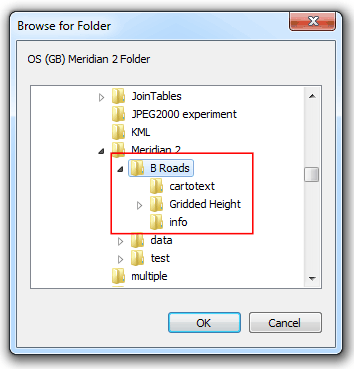
Use the Browse for Folder dialog to find the folder containing the OS (GB) Meridian 2 Shapefiles and click OK.
In this example this is the B Roads folder:

The files will load and progress will be displayed at the bottom of the Ordnance Survey Great Britain (OS GB) Data Sources dialog.
When loading is complete the dialogs will close.
Loading all the Meridian 2 data will take a long time. Therefore it is recommended that you create a folder and insert only the required data, i.e. B roads, plus the data folders (shown above).
It is also recommend that you save your graphic information to a Base Dataset (BDS) file for future use to prevent the loading process being carried out on every subsequent opening.
Note: OS (GB) Meridian 2 is also available in two other formats:
NTF format - NTF is a nationally agreed standard for the transfer of geographical data. SIS will open Meridian 2 NTF files and convert non-topological NTF items to topological items.
DXF format - Meridian 2 DXF conforms to AutoCAD release 12. With Meridian 2 DXF each feature is free-standing with no topological relationship to any other feature and therefore does not support topology.
SIS supports all OS digital data products in National Transfer Format (including those for Great Britain, Northern Ireland and the Irish Republic) and OS MasterMap GML or GZIP.
To open individual files select the File option in the Create New Overlay wizard and select from the following OS-related file suffixes:
Send comments on this topic.
Click to return to www.cadcorp.com
© Copyright 2000-2017 Computer Aided Development Corporation Limited (Cadcorp).