A Cadcorp Basemap Database is a read only, multi-user tile cache. Only an administrator (defined through file permissions) should be allowed to re-build or alter the tile cache.
Note: When exporting to a BDB SIS will try to export everything in the Map Window including ALL Overlays, therefore set any overlays not required for export to a status of Invisible.
The export will create tiles based on the scale thresholds of the dataset in the SWD. For example if you have 250k, 50k, 10k and then MasterMap, the BDB would have all these datasets within it, therefore as you zoom in, it would show the 250k, then the 50k, followed by the 10k and finally the MasterMap, in the same manner as for the original SWD.
Select Export to File [File-Export] and select the Cadcorp Basemap Database (*bdb) option from the Save as type drop-down in the Export As dialog. Enter the file name and click Save.
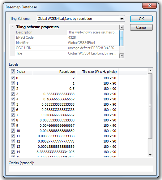
The Basemap Database dialog will be displayed:

Tiling Scheme
The tiling scheme defines how the map is broken up into a grid for creating tiles. The tiling schemes available will depend on the coordinate reference system used, choose from the following:
Global WGS84 Lat/Lon, by resolution
Description: This well-known scale set has been defined for global cartographic products. Rounded pixel sizes have been chosen for intuitive cartographic representation of raster data. Some values have been chosen to coincide with original pixel size of commonly used global products like STRM (1" and 3"), GTOPO (30") or ETOPO (2' and 5'). Scale denominator and approximated pixel size in metres are only accurate near the equator.
EPSG Code: 4326
Identifier: GlobalCRS84Pixel
OGC URN (Universal Resource Name): urn:ogc:def:crs:EPSG:8.3:4326
Title: Global WGS84 Lat/Lon, by resolution
Global WGS84 Lat/Lon, by scale
Description: This well-known scale set has been defined for global cartographic products. Rounded scales have been chosen for intuitive cartographic representation of vector data. Scale denominator is only accurate near the equator.
EPSG Code: 4326
Identifier: GlobalCRS84Scale
OGC URN (Universal Resource Name): urn:ogc:def:crs:EPSG:8.3:4326
Title: Global WGS84 Lat/Lon, by scale
Google Maps/Bing Maps-compatible
Description: This well-known scale set has been defined to be compatible with Google Maps and Microsoft Live Map projections and zoom levels. Level 0 allows representing the whole world in a single 256x256 pixels. The next level represents the whole world in 2x2 tiles of 256x256 pixels and so on in powers of 2. Scale denominator is only accurate near the equator.
EPSG Code: 3857
Identifier: GoogleMapsCompatible
OGC URN (Universal Resource Name): urn:ogc:def:crs:EPSG:8.3:3857
Title: Google Maps/Bing Maps-compatible
Netherlands EPSG:28992
Description: Tiling scheme for Dutch applications, defined by geonovum.nl
EPSG Code: 28992
Identifier: NLDEPSG28992Scale
OGC URN (Universal Resource Name): urn:ogc:def:crs:EPSG:8.3:28992
Title: Netherlands EPSG:28992
OS OpenSpace
Description: OS OpenSpace-compatible tiling scheme
EPSG Code: 27700
Identifier: OSOpenSpaceCompatible
OGC URN (Universal Resource Name): urn:ogc:def:crs:EPSG:8.3:27700
Title: OS OpenSpace
OS OpenSpace Fixed Tile Size 'Plus'
Description: OS OpenSpace-like tiling scheme with fixed tile sizes, and extended with additional large-scale resolutions, down to 0.1m per pixel
EPSG Code: 27700
Identifier: OSOpenSpaceFixedTileSizePlus
OGC URN (Universal Resource Name): urn:ogc:def:crs:EPSG:8.3:27700
Title: OS OpenSpace Fixed Tile Size 'Plus'
OS OpenSpace 'Plus'
Description: OS OpenSpace-compatible tiling scheme extended with additional large-scale resolutions, down to 0.1m per pixel
EPSG Code: 27700
Identifier: OSOpenSpaceCompatiblePlus
OGC URN (Universal Resource Name): urn:ogc:def:crs:EPSG:8.3:27700
Title: OS OpenSpace 'Plus'
Levels
Check the tickbox or tickboxes appropriate to the resolution(s) you wish to export.
Credits (optional)
Enter any text you want to add to the exported file. This will display in the bottom right-hand corner of the Map Window when the file is opened in SIS.
When the entries are complete click OK.
The export will now commence.
A Cancel button is displayed and a green progress bar will inform you of the export progress.

Note: The larger the Index number(s) selected in the Levels pane, i.e. the lower the resolution, the longer the export will take. You may therefore decide to click Cancel and reselect the resolution(s).
This export is not available as an API method.
See full list of Export Formats
Click to return to www.cadcorp.com
© Copyright 2000-2017 Computer Aided Development Corporation Limited (Cadcorp).