Process
The Process theme applies Processing to items before they are drawn.
Click Home > Add Theme > Operation and select Process.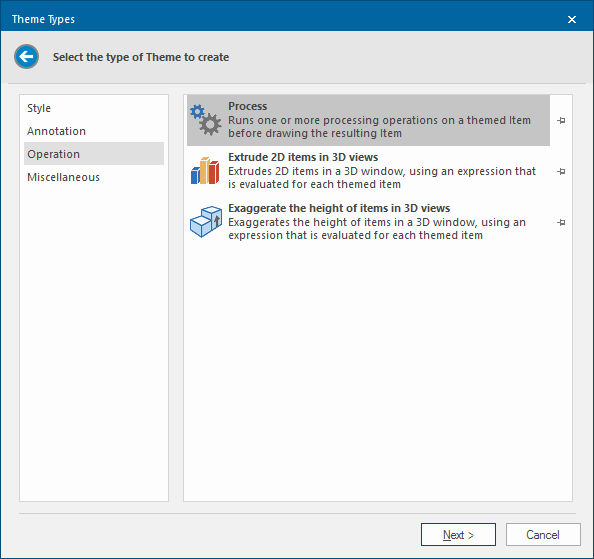
Click Next to see the Processing Steps window.
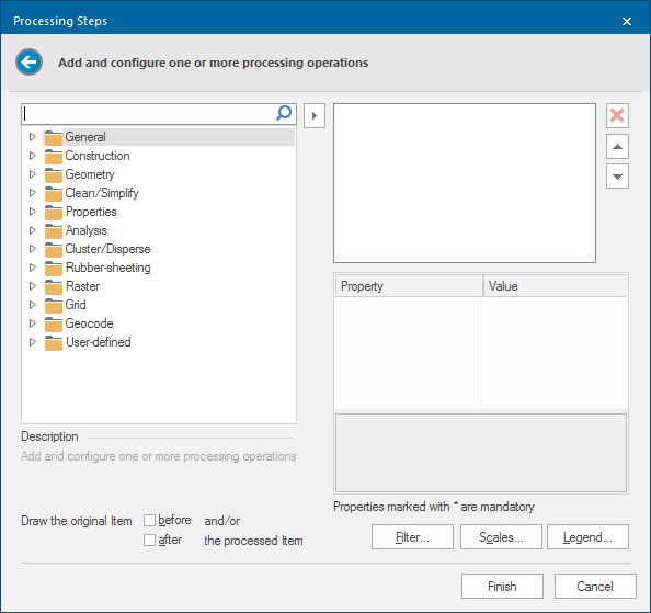
Select the required process operation from the appropriate folder in the left hand pane and click the right-arrow button to show the selected process in the right-hand pane.
The parameters associated with the process are then shown in the right-hand lower pane. Enter the value(s) for the process.
Some processes do not require any inputs.
The Draw the original Item - before and after tickboxes control the drawing order in relation to the processed Item.
When this dialog is complete click Finish.
The processing operations are categorised as shown below. Click on the category title, or the individual process, to go to the page containing the process descriptions.
Notes:
Properties marked with an * in the process descriptions are mandatory.
The Process Theme can only use operations that take a single Item in, and pass a single Item out. They also cannot use operations that have an Overlay as a parameter, for example the Geometry 'Clip' operations.
General
| Copy | Copies an existing Item |
Construction
| Create box | Creates a rectangular Polygon, around a centre point |
| Create ellipse | Creates an elliptical Polygon |
| Create from WKB | Creates an Item from OGC Well-known Binary |
| Create from WKT | Creates an Item from OGC Well-known Text |
| Create line (bearing/distance) | Creates a LineString from a bearing and distance |
| Create point | Creates a Point Item |
| Create sector (bearing/angle) | Creates a sector Polygon from a bearing and angle. |
| Create sector (start/end) | Creates a sector Polygon from a start and end angle |
Geometry
| 'Dig' shape | Gets the 'dig' shape (a concave hull) of an Item using Park/Ho's algorithm |
| Alpha shape | Gets the Alpha shape (a concave hull) of an Item, using Edelsbrunner's algorithm |
| Boundary | Gets the boundary of an Item. |
| Chi shape | Gets the Chi shape (a concave hull) of an Item, using Duckham's algorithm |
| Close | Closes any open geometry, joining the end to the start |
| Convex hull | Creates a convex hull Polygon around an Item |
| Ensure anti-clockwise | Reverses the geometry of polygonal Items with coordinates specified clockwise, making them anti-clockwise instead. Other Items are left alone. |
| Envelope | Creates an envelope Polygon around the extents of an Item |
| Facet | Facets curved geometry segments into a straight geometry |
| Fill | Fills the boundary of an Item |
| Move | Moves an Item in X and/or Y and/or Z |
| OOBB (aligned) | Creates an object orientated bounding box (OOBB) Polygon around an Item, aligned to the 'dominant' angle of the Item geometry |
| OOBB (minimum) | Creates the minimum (smallest area) object orientated bounding box (OOBB) Polygon around an Item |
| Remove interior loops | Removes interior loops (holes and islands) from Polygons, leaving only exterior loops |
| Reverse geometry | Reverses the geometry of an Item |
| Rotate | Rotates the geometry of an Item about a hook point |
| Scale | Scales the geometry of an Item about a hook point |
| Smooth (mid-points) | Smoothes the geometry of an Item, keeping segment mid-points fixed |
| Smooth (vertices) | Smoothes the geometry of an Item, keeping vertices fixed |
| Strip geometry | Strips the geometry of an Item, leaving an Empty Item |
Clean/Simplify
| Generalise (Douglas-Peucker N) |
Generalises geometry using a variation of the Douglas-Peucker algorithm that is limited by the number of output points |
| Generalise (Douglas-Peucker) |
Generalises geometry using the Douglas-Peucker algorithm |
| Generalise (Perpendicular Distance) |
Generalises geometry using the Perpendicular Distance algorithm |
| Generalise (Radial Distance) |
Generalises geometry using the Radial Distance algorithm |
| Generalise (Reumann-Witkam) |
Generalises geometry using the Reumann-Witkam algorithm |
| Remove self-intersections | Removes self-intersections, e.g. a bow-tie |
| Remove short segments | Removes segments shorter than a tolerance |
| Remove spikes | Removes vertices that cause a spike |
| Remove straight segments | Removes vertices between straight, or near straight segments. |
| Simplify | Simplifies the geometry of an item, so that it matches the OGC 'simple' form |
Properties
| Remove all attributes | Removes all attributes from an Item |
| Remove attribute | Removes an attribute from an Item |
| Set property | Sets a property on an Item |
| Set styles | Sets styling information on an Item |
| Strip styles | Strips all styling information from an Item. Returns Brush, Pen and Symbol Items to "By Overlay" |
Analysis
| Buffer | Creates a buffer around an Item |
| Buffer (doughnut) | Creates a buffer around the boundary of a Polygon |
| Buffer (inside) | Creates a buffer around the boundary of a Polygon that only contains the parts that are inside the Polygon |
| Buffer (interior) | Creates a buffer inside a Polygon that excludes the parts of a doughnut buffer around the boundary of the Polygon |
| Buffer (outside) | Creates a buffer around the boundary of a Polygon that only contains the parts that are outside the Polygon |
| Geodetic buffer | Creates a 'geodetic' buffer around an Item |
| QZone buffer | Creates a QZone buffer around an Item |
Rubber-sheeting
| Create Displacement | Creates a Displacement Item, for use in rubber-sheeting |
Raster
| Compress | Compresses a bitmap |
| Convert to grayscale | Converts a colour bitmap to a grayscale bitmap |
| Convert to sepia | Converts a colour bitmap to a sepia bitmap |
| Crop | Crops a bitmap |
Grid
| Create Terrain Ruggedness Index | Creates a Terrain Ruggedness Index map |
| Create Topographic Position Index | Creates a Topographic Position Index map |
| Create aspect | Creates an Aspect map |
| Create hillshade | Creates a shaded relief map from a Grid |
| Create roughness | Creates a Roughness map |
| Create slope | Creates a Slope map |
| Getis-Ord GI* (Z score) | Finds the locations and extents of point clusters in two-dimensional space. |
| Getis-Ord GI* (p-value) | Finds the locations and extents of point clusters in two-dimensional space. |
| Grid * Number | |
| Grid + Number | |
| Grid - Number | |
| Grid / Number | |
| Max(Grid, Number) | |
| Min(Grid, Number) | |
| Number - Grid | |
| Number / Grid | |
| Set cell value | Sets the value of all Grid cells that match a comparison against the 'from' value to the 'to' value |
| Set grid pixel type | Sets the grid pixel type (bit depth) of an image. |
| Transform Grid |
Geocode
| MapQuest Open | Connects to the MapQuest Open Geocoding service |
| Microsoft Bing Maps | Connects to the Microsoft Bing Maps geocoding service |
| OS (GB) Code-Point Open | Searches OS (GB) Code-Point Open data, by postcode |
| OS (GB) National Grid Reference | Matches search strings against OS (GB) National Grid References |
| OS (GB) National Grid Reference (Jersey) | Matches search strings against OS (GB) National Grid References for Jersey |
User-defined
| Remove all attributes | Removes all attributes from an Item |
| Strip styles | Strips all styling information from an Item |
Filter, Scale and Legend buttons

Click here for a description of the functions of these three buttons.
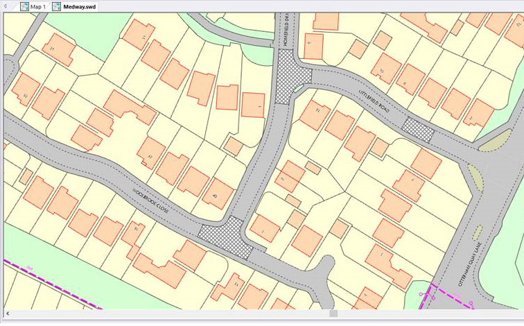
If, for example, you want to display a symbol for traffic calming in the location of the speed bumps (black hatch pattern):
Create a process theme.
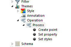
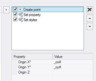
In this example the theme is made up of three processes;
Create point will create a point at a x,y,z location. In this example use _ox# and _oy#
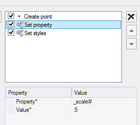
The second process is to set up a property. In this example the symbol was too large so set the scale to .5, making it half the size.
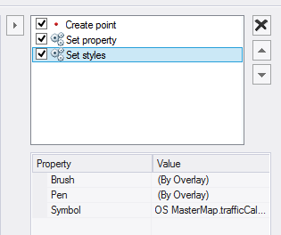
The last process sets the style of the symbol.
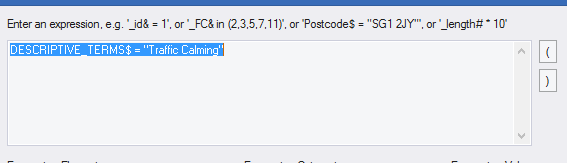
The Process Theme (like other themes) can have a filter or scale threshold.
In this example use a filter so that symbols only appear for the “Traffic Calming”:
The resulting map is:
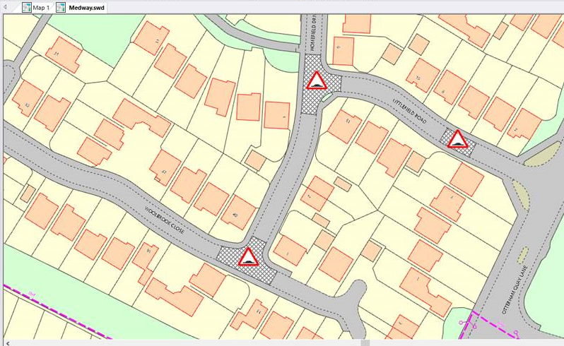
The relationship between the symbol and the hatch is dynamic. The theme can be stored in the NOL, like any other theme and reused again.
As an aside, the process can be used to create data. If you want to “convert” these areas to points, a similar process to this theme could be used to create an overlay of points.
Click here for Process Theme properties.