Geodetic Lines and Buffers
For many applications, sufficient accuracy is provided by 2D graphical constructions, and you do not need to consider the curvature of the earth when using them. However, for some tasks, such as plotting flight paths or navigation routes, 2D constructions would not be sufficiently accurate.
SIS Desktop 9 provides tools for constructing items that do take the earth’s curvature into account. Using the following commands you can create:
This is now part of the Buffers dialog:
Create geodetic buffer
A geodetic buffer is a buffer around an item that takes into account the earth’s curvature.
- Select an item that you want to buffer.
- Choose Buffer [Analysis-Buffer] - Geodetic.
- Enter the radius in metres for the buffer.
- In the Parameter box, enter a value that determines the resolution or accuracy of the buffer. For greater accuracy, use higher values, but bear in mind this will take longer to process.
- Click OK to create the buffer.
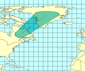
SIS Desktop 9 constructs the buffer by constructing a temporary set of circles along the route of the buffer. The number you provide in the dialog determines how many points are used to construct each circle, thus defining the accuracy of the resulting buffer.