Graticule
A Graticule is a special kind of LineString item that automatically draws latitude and longitude ticks and graticules using the world position of the contents of a Map Frame item.
Because Graticule items can be time-consuming to set up, commands are provided for storing and recalling Graticule Style objects from Named Object Libraries.
Properties
- Closed: _closed&
Does the geometry of the item form a closed loop? - Dicing: _graticuleDicing&
Should Graticule dicing be drawn?
This parameter can only be set in level 1.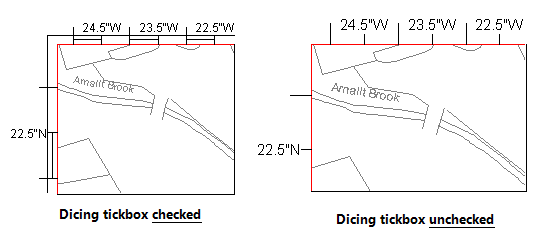
- Double-sided ticks: _graticuleDoubleSidedTick&
Should the Graticule tick be drawn on both sides of the Graticule outline at this level?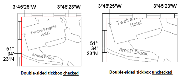
- Draw labels: _graticuleLabel&
Should the Graticule ticks be labeled at this level?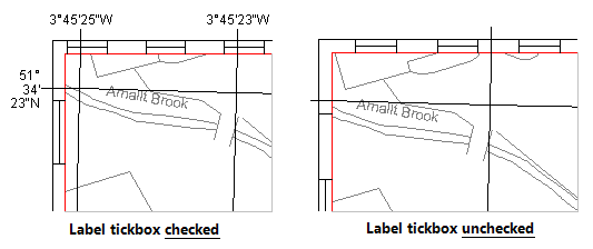
- Draw margin: _graticuleMargin&
Should a margin be drawn around the Graticule tick lines at this level.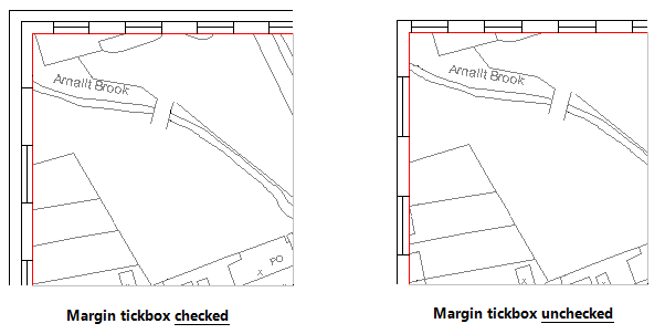
- Geometry class: _classGeom$
The C++ class used to store an item's geometry. This is handled automatically. You can see what precision an item's geometry is stored with by recognising the geometry classes. - Graticule brush: _graticuleBrush$
The Brush with which to draw the Graticule label text at this level. - Graticule level: _graticuleLevel&
The current Graticule level. Each Graticule has up to eight levels of tick line (numbered from 0 to 7), each of which can have properties set. - Graticule pen: _graticulePen$
The Pen with which to draw the Graticule lines and label text at this level. - Graticule span: _graticuleSpan&
The type of Graticule span at this level.
Valid values are:
| SIS_GRATICULE_NONE | No lines appear across the map frame, but Labels or Ticks (Tick length) can still be drawn if required. |
| SIS_GRATICULE_GRID | Draw a grid latitude and longitude lines. |
| SIS_GRATICULE_CROSSHAIR | Draw a grid of crosshairs at latitude and longitude intersections. |
| SIS_GRATICULE_CROSSHAIR_TEXT | Draw a grid of crosshairs annotated with latitude and longitude text. |
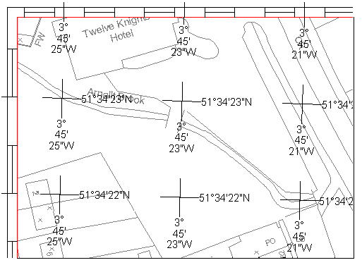
- Latitude format: _graticuleFormatLat$
The format string for the latitude Graticule label text at this level, using the following format specifications:%dor%DPrint the degrees ( %Dappends a degrees symbol °)%mor%MPrint the minutes ( %Mappends a ')%sor%SPrint the seconds ( %Sappends a ")%cor%CPrint the direction (N, S, E, or W) %d,%D,%m,%M,%sand%Scan be modified to print fixed width and precision (like the C printf function), e.g.:%4.2s - Latitude step: _graticuleStepLat#
The Graticule latitude step, in degrees, at this level. - Longitude format: _graticuleFormatLon$
The format string for the longitude Graticule label text at this level, using the following format specifications:%dor%DPrint the degrees ( %Dappends a degrees symbol °)%mor%MPrint the minutes ( %Mappends a ')%sor%SPrint the seconds ( %Sappends a ")%cor%CPrint the direction (N, S, E, or W) %d,%D,%m,%M,%sand%Scan be modified to print fixed width and precision (like the C printf function), e.g.:%4.2s
- Longitude step: _graticuleStepLon#
The Graticule longitude step, in degrees, at this level. - Number of vertices: _np&
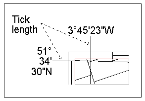
The number of vertices in the item's geometry. - Tick length: _graticuleTickLength&
The length, in millimetres, of a Graticule tick, at this level.