WMTS
A Web Map Tile Service (WMTS) is an Open Geospatial Consortium (OGC) standard protocol for serving pre-rendered georeferenced map tiles over the Internet.
A WMTS can be created by serving out an SWD through GeognoSIS 
Alternatively, you may be connecting directly to a third party WMTS. This is where the GET CAPABILITIES option is useful to discover and populate as much information in this dialog as possible.
There are a number of products which can serve WMTS and these can be configured in different ways. For example, to use a WMTS served by GeoServer in Cadcorp SIS WebMap 9.1, you will need to ensure that a "Default" style is defined by the service. The provider of the WMTS should check this in GeoServer.
To create a WMTS layer, select Configuration > Add Layer > WMTS.
Adding the data
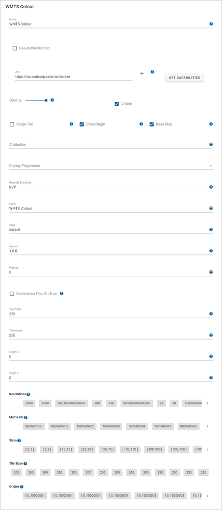
| Field | Description |
| Name | An appropriate user-added name. |
| Use Authentication |
Enable to force map user to use authentication. This can be in the form of an API key or username/password credentials. |
| Add URL | The URL to the WMTS, if it is being served out by GeognoSIS this can be found in the capabilities document. |
| Opacity | Increase or decrease the layer's opacity. |
| Visible | Tick this checkbox for data to appear on the map and in the Map Features dialog. |
| Single Tile |
Tick this checkbox to return the whole map as a single tile. A single tile reduces the number of requests made to the server however it prevents the map from appearing as a slippy map. If you pan around, the whole tile is reloaded for the new location. |
| Cross Origin |
Tick this option to allow Cross Origin Resource requests (CORS service), for example if the SWD is referencing an external database or using web services to access data |
| Base Map |
This should always be enabled. It defines the layer as a base layer. |
| Copyright Statement | Use to customise any copyright information to display on layer. |
| Display Projection | Choose from a predefined list of SRID numbers to define what projection the cache will be drawn in. More SRID numbers can be added from the CRS options. |
| Request Encoding | Request encoding refers to the way data is structured and sent in an HTTP request. Two common methods for encoding request data are REST (Representational State Transfer) and KVP (Key-Value Pair). |
| Layer | Layer name from the Capabilities document |
| Style | If the WMTS has multiple styles available, select the style from the dropdown. This is populated by using the GET CAPABILITIES option |
| Version | Automatically populated when you select a layer using Get info from capabilities (if not filled automatically, ensure you add the details manually.) |
| Preload | Load low-resolutions tiles up to pre-load levels |
| Use interim tiles on error | Enable this option to allows WebMap to use an interim (lower resolution) tile if the current tile has an error (e.g. it does not exist). This provides a better visual experience when tiles are not present on the server. |
| Tile Width | If not using the single tile option, data requests from GeognoSIS will be returned in tiles. This value refers to the tile width (measured in number of pixels). The width is set to 256 as default. |
|
Tile Height |
If not using the single tile option, data requests from GeognoSIS will be returned in tiles. This value refers to the tile height (measured in number of pixels). The width is set to 256 as default. |
| Origin X | X Coordinates of origin. If the WMTS tile matrix has an origin different to 0,0 then the origin x coordinate needs to be set here. |
| Origin Y | Y coordinates of origin. If the WMTS tile matrix has an origin different to 0,0 then the origin x coordinate needs to be set here. |