.gif) Iso-route Iso-route
Iso-route Iso-route
.gif) Iso-route constructs an iso-route (traced network) from a point.
Iso-route constructs an iso-route (traced network) from a point.
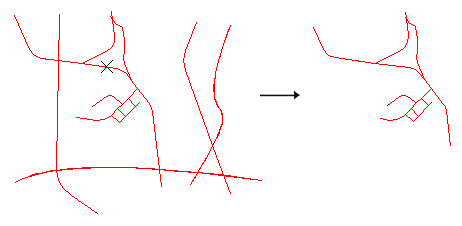
The iso-route is traced over existing graphics which shows the distance you could travel if you were leaving from a given point and your journey was subject to given conditions.
SIS creates the iso-route as a MultiLineString item, which covers all the places that can be reached. As it overlays existing data, it is best created on a different overlay from the original data, so that you can view it easily.
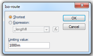
On selecting this command the Iso-route dialog will be displayed:
Shortest
Select this option to show all locations that can be reached via a route which is shorter than the distance entered in the Limiting value field of this dialog.
Expression
Select this option to use an expression to calculate the iso-route. For example, an expression may be used to take into account the speed limits on the roads in order to calculate an iso-chrone based on time rather than distance.
Limiting value
This field will use the current linear units (set by CRS [Home-Map], Units tab).
Example
To construct an iso-route which covers all places on a street map which are within 1000m of a hospital. Alternatively you could carry out drive-time analysis and find out where you could reach in a given time when starting from a given point and driving at a given speed (which would be useful at a Fire Station).
Iso-routeIf you ask SIS to find the shortest route, the _length# property of the items is used.
You could create an expression to enable the “cost” of each link to be used, or if the expression were:
_length#/SpeedLimit&
then the time for each link would be calculated.
Note: the attribute SpeedLimit& must exist for each link.
If you chose to base the route on the shortest distance, you need to select that option and enter the limiting value in the Iso-route dialog:
This example shows an iso-route that will be constructed 1000m (assuming current linear units are set to metres) in all directions from the start point.
If you chose a time-based expression (e.g. distance divided by speed), this should be the number of seconds to travel, this will create an iso-chrone.
The iso-route is created. If it was created on a separate overlay from the original data, you will be able to view it separately and use it to create a Buffer.
Starting from the X point in the following road network could result in the iso-route shown on the right.
Top of page
Click to return to www.cadcorp.com
© Copyright 2000-2017 Computer Aided Development Corporation Limited (Cadcorp).