Analysis (Process operations)
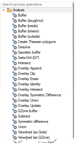
Select Create > Process > Analysis.
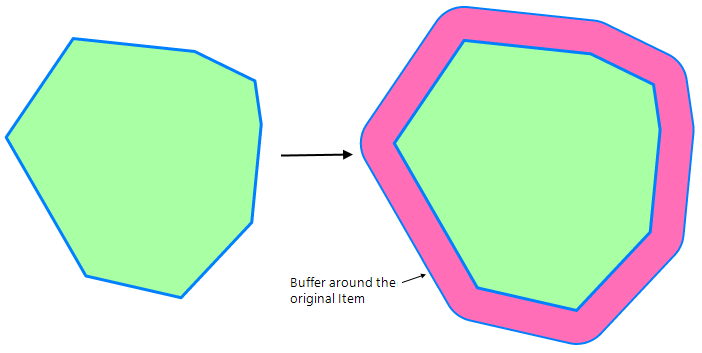
Creates a buffer around an Item.
Radius*: The buffer radius as a simple value or as an expression.
TIP: See also Buffer command.
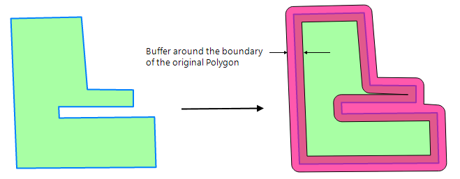
Creates a buffer around the boundary of a Polygon.
Radius*: The buffer radius, as a simple value, or as an expression.
TIP: See also Buffer command.
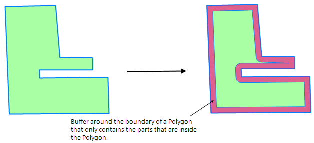
Creates a buffer around the boundary of a Polygon that only contains the parts that are inside the Polygon.
Radius*: The buffer radius, as a simple value, or as an expression.
TIP: See Buffer command.
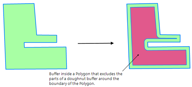
Creates a buffer inside a Polygon that excludes the parts of a doughnut buffer around the boundary of the Polygon.
Radius*: The buffer radius, as a simple value, or as an expression.
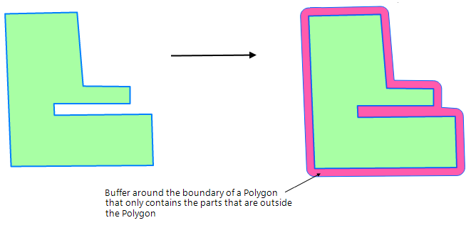
Creates a buffer around the boundary of a Polygon that only contains the parts that are outside the Polygon.
Radius*: The buffer radius, as a simple value, or as an expression.
Clusters Items together within regular, rectangular grid cells.
|
Property |
Value |
|
|
Cell height* |
The height of a cluster grid cell, as a simple value, or as an expression, e.g. '12.34', or '_sx#/12' |
|
|
Cell width* |
The width of a cluster grid cell, as a simple value, or as an expression, e.g. '43.21', or '_sx#/34' |
|
|
Origin X |
The X coordinate of the origin of the cluster grid, as a simple value, or as an expression, e.g. '12.34', or '_ox#' |
|
|
Origin Y |
The Y coordinate of the origin of the cluster grid, as a simple value, or as an expression, e.g. '43.21', or '_oy#' |
|
This function aggregates items within a grid of a user-defined size. Items found within a grid cell are represented in the output by a point item with an attribute that shows the sum of the items it represents.
Examples of use may include aggregating data for use at lower scales where exact geographic location is less important than knowing how many items there are.
This example shows the result of the Cluster function: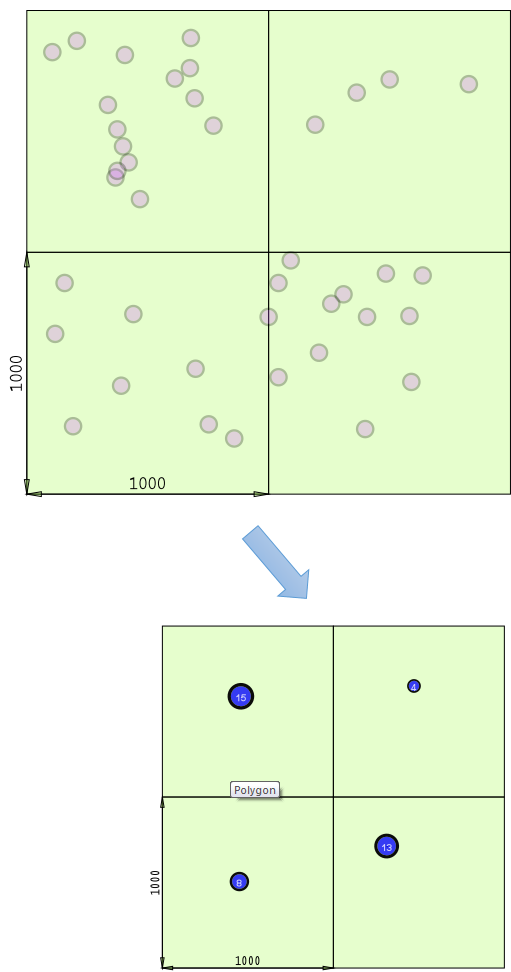
Creates Thiessen Polygons of influence around the hook point of Items.
|
Property |
Value |
|
|
High X |
The high X (right) value of the extents box of the Thiessen Polygons as a simple value or as an expression. |
|
|
High Y |
The high Y (top) value of the extents box of the Thiessen Polygons as a simple value or as an expression. |
|
|
Low X |
The low X (left) value of the extents box of the Thiessen Polygons as a simple value or as an expression. |
|
|
Low Y |
The low Y (bottom) value of the extents box of the Thiessen Polygons, as a simple value, or as an expression. |
|
|
Margin |
The margin by which the extents should be padded, as a simple value, or as an expression. |
|
TIP: See Spatial Analysis-Thiessen Polygons and the Thiessen Polygons command for an example of creating a Thiessen Polygon.
Merges Items based on attribute values.
Expression*: The merge value, as a simple property name, or as an expression.
Example: _area#>1000
The initial map with areas shown by a Labels theme:
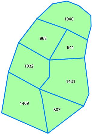
All the selected items that match the Expression*_area#>1000, are merged together (Boolean Union) into a single item:
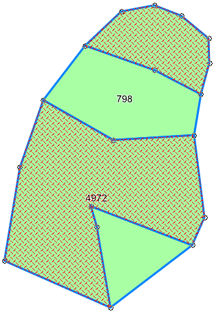
The rest of the selected items are merged into another single item:
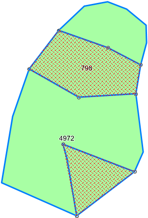
TIP: See also Dissolve command.
Creates a 'geodetic' buffer around an Item i.e. a buffer that takes the curvature of the Earth into account.
|
Property |
Value |
|
|
Distance* |
The geodetic buffer radius in metres as a simple value or as an expression, eg '12.34' or Max(123.4,Sqrt(_area#))'. |
|
|
Number of points |
The number of points to use when calculating the buffer as a simple value or as an expression, eg '64' or 'Max(64,Int(Floor(0.5*(_sx#+sy#))))' ( the default value is 4. |
|
Calculates the Getis-Ord Gi* statistic for each feature in a dataset.
|
Property |
Value |
|
|
Distance |
This is the threshold distance when performing a search for polygons in the local neighbourhood; any polygons with centroids outside this distance will be ignored when calculating the local average value. This option is only used when the Relationship (see below) parameter is set to Inverse distance, Inverse distance squared, Fixed distance band or Zone of indifference. If no other centroids can be found within this distance, the Z and P values for the polygon will not be set and a further column will be created in the schema holding an error value. |
|
|
Distance method* |
Select the required distance measure: Euclidian: As the crow flies, ie a straight line. Manhattan: Imitates moving across a city block: distances are traversed at right angles i.e. the sum of the difference between the two point coordinates. |
|
|
Expression |
Analysis variable to calculate Gi* statistics on eg CrimesTotal# The input value for analysis, as a simple property name, or as an expression, eg 'IncidentCount&' or 'NumIncidentsJan& + NumIncidentsFeb&' The expression must be appended with the # / & /$ symbol. |
|
|
Number of neighbours |
The number of neighbours to factor in to the local average calculations when using the K Nearest Neighbours Spatial Relationship parameter – will search for that many of the nearest centroids to the centroid of the polygon being calculated upon. |
|
|
Relationship* |
Conceptulization of spatial relationship. Inverse distance The weighting for features will decrease regularly with distance from the original centroid up to the distance threshold Inverse distance squared Same as Inverse Distance, however the weighting will decrease more severely with distance. Fixed distance band Every polygon within the distance threshold is counted as being ‘in’ and weighted 1, everything outside is counted as ‘out’ and weighted 0. Zone of indifference Combination of Fixed Distance band and Inverse Distance. Everything inside the threshold is ‘in’ and weighted 1, after this point the weighting tapers off towards 0. K Nearest Neighbour Will search for the K nearest centroids to the polygons centroid and use these as the Local Neighbourhood with weightings of 1, any others will be ignored (weighted 0). |
|
Combines the Items using the intersect boolean operation, i.e. only overlaps are kept. No input values required.
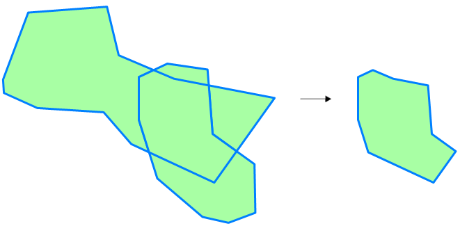
TIP: See also Intersect command.
Overlay append.
Attribute Prefix
TBD
Overlay Attribute Prefix
TBD
Overlay*
The overlay with which to perform the operation. A drop-down allows you to select the required overlay:
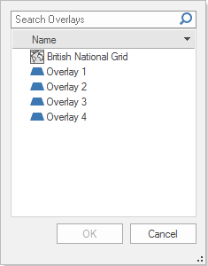
Select the overlay and click OK.
Overlay clip.
Attribute Prefix
TBD
Overlay Attribute Prefix
TBD
Overlay*
The overlay with which to perform the operation.
A drop-down allows you to select the required overlay:

Select the overlay and click OK.
Overlay erase.
Properties
Attribute Prefix
TBD
Overlay Attribute Prefix
TBD
Overlay*
The overlay with which to perform the operation.
A drop-down allows you to select the required overlay:

Select the overlay and click OK.
Overlay identity.
Attribute Prefix
TBD
Overlay Attribute Prefix
TBD
Overlay*
The overlay with which to perform the operation. A drop-down allows you to select the required overlay:

Select the overlay and click OK.
Overlay intersect.
Attribute Prefix
TBD
Overlay Attribute Prefix
TBD
Overlay*
The overlay with which to perform the operation.
A drop-down allows you to select the required overlay:

Select the overlay and click OK.
Overlay*
The overlay with which to perform the operation.
A drop-down allows you to select the required overlay:

Select the overlay and click OK.
Attribute Prefix
TBD
Overlay Attribute Prefix
TBD
Overlay*
The overlay with which to perform the operation.
A drop-down allows you to select the required overlay:

Select the overlay and click OK.
The overlay with which to perform the operation.
A drop-down allows you to select the required overlay:

Select the overlay and click OK.
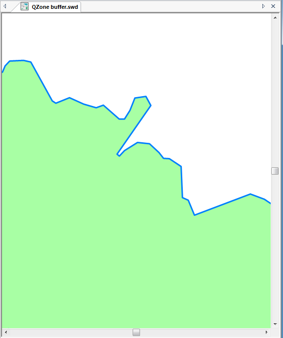
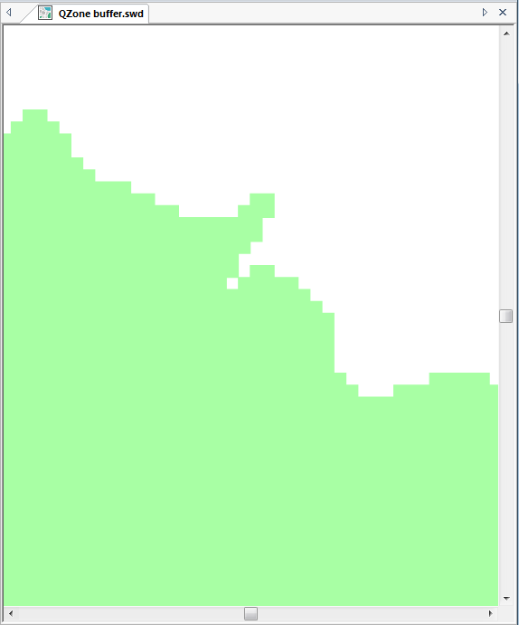
Creates a QZone buffer around an Item.
|
Property |
Value |
|
|
Cellsize* |
The QZone cell size, as a simple value, or as an expression. |
|
|
Radius |
The buffer radius, as a simple value, or as an expression. |
|
Original map:
Typical display obtained using QZone buffer:
TIP: See also QZone command.
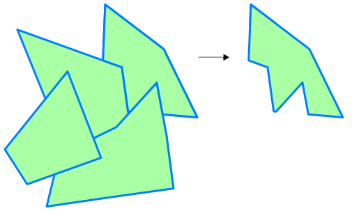
Combines the Items using the subtract boolean operation, ie any overlaps between the first Item and the second and subsequent Items are removed. No input values required.
The output would be as shown:
Combines the Items using the symmetric difference boolean operation, generating alternate geometries, i.e. any overlaps are removed. No input values required.
The area of overlap is deleted, and a MultiPolygon item is created as shown below:
If there are multiple areas of overlap, they are alternately deleted or left intact:
TIP: See also Symmetric Difference.
Combines the Items using the union operation, i.e. all parts of both Items are kept.

TIP: See Union command
Creates 'Viewshed' Grids from the Item origin over source Grid Items from another Overlay.
|
Property |
Value |
|
|
Filter Expression |
A filter expression, e.g. '_FC& IN (1,2,3)' or 'grid_type$="DEM", to use when finding the source Grid Items. |
|
|
Overlay* |
The name of the Overlay containing the source Grid Items. |
|
|
Radius* |
The 'Viewshed' radius, as a simple value, or as an expression, e.g. '12.34' or 'Max(123.4,broadcast_range#)' |
|
Creates a'Viewshed' QZone from the Item origin over source Grid Items from another Overlay.
|
Property |
Value |
|
|
Filter Expression |
A filter expression, e.g. '_FC& IN (1,2,3)' or 'grid_type$="DEM", to use when finding the source Grid Items. |
|
|
Overlay* |
The name of the Overlay containing the source Grid Items. |
|
|
Radius* |
The 'Viewshed' radius, as a simple value, or as an expression, e.g. '12.34' or 'Max(123.4,broadcast_range#)' |
|
Creates 'Viewshed' Grids from the Item origin over source Grid Items from another Overlay, containing only the cell values 1 (in Viewshed) and 0 (not in Viewshed).
|
Property |
Value |
|
|
Filter Expression |
A filter expression, e.g. '_FC& IN (1,2,3)' or 'grid_type$="DEM", to use when finding the source Grid Items. |
|
|
Overlay* |
The name of the Overlay containing the source Grid Items. |
|
|
Radius* |
The 'Viewshed' radius, as a simple value, or as an expression, e.g. '12.34' or 'Max(123.4,broadcast_range#)' |
|