Updating Attributes of RDBMS Cursor Dataset Overlays
Archiving and Updating Attributes
Archiving and Adding New Attributes
Adding New Attributes to RDBMS Cursor Dataset Spatial Tables
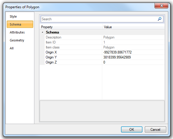
When updating attribute data on an RDBMS cursor dataset overlay it is recommended that the user uses the Properties of Polygon dialog box:
To display the box:
This dialog box generates one update statement whether one or more attributes is changed. Updates made via the Properties Control Bar or through the table view cause updates statements to be made for each attribute changed which causes unnecessary processing for the database server.
The method used for updating attributes is particularly important if RDBMS cursor dataset database archiving has been switched on. Each update statement executed by the RDBMS cursor dataset database generates archive information. If an update activity in SIS requires you to change the value of one or more attributes as a part of a single feature edit then the feature properties dialog box should be used to update the attributes. If any other method is used an archive will be created for each attribute changed.
The worst case scenario is that unnecessary archiving will be created.
Adding new attributes to an RDBMS overlay results in a change to the structure of the underlying RDBMS table. The creation of new attributes adds new columns to the table.
Information contained in columns added to a table after archiving has been switched on will not be archived.
It is recommended that users do not change the structure of a table after applying archiving to that table.
Qualified database administrators could use the following workflow to get around this situation:
You can add new attributes to spatial layers created using the RDBMS Cursor Datasets. The process is the same as adding a new column to the underlying database table. The overlay must have been created by the owner of the table in order to add a new attribute.
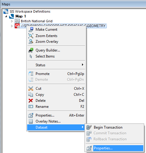
To add a new attribute right-click on the database overlay in the Maps Control Bar and select Dataset > Properties...
The Cursor Dataset Details dialog will be displayed:
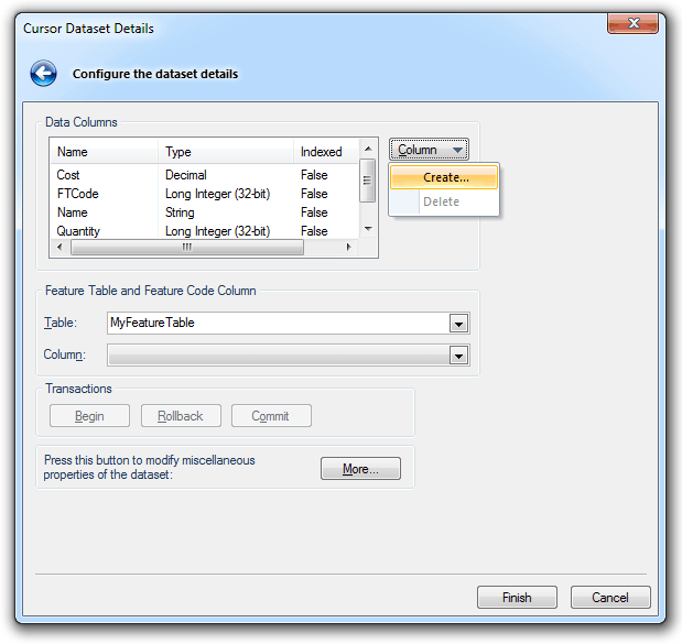
Data Columns
Name/Type/Indexed
Fields in the dataset.
Column
Create
Creates a new field.
The New Field dialog will be displayed:
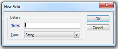
Name - name for the new field.
Type - select the type from the drop-down box (see Attributes Overview).
Delete
Deletes an existing field.
Index
Create Index
Creates an Index on an existing field.
Delete Index
Deletes an Index on an existing field.
Feature Table and Feature Code Column
Table
The Feature Table to use for feature-coded Items in this Dataset.
Feature-coded Items get information about their Feature Code from this Feature Table.
Column
The Field that will be used to set the Feature Code on Items in the Dataset.
Transactions
Begin/Rollback/Commit
Begin starts a new transaction on the dataset, the Rollback and Commit buttons will become active.
You now have two options:
- Rollback - all of the edits made within the transaction will be undone (as a whole).
- Commit - all of the edits made within the transaction will be committed (save all of the edits made within the transaction).
More
Allows you to view and modify further dataset properties.
In the case of Oracle the following AOracleSpatialCursorDts dialog is displayed:
Coordinates
The coordinate system that the dataset items are defined in. To view or edit the coordinate system details drop-down the combo box list, and press the right arrow at the bottom.
Feature Table
The feature table to use for feature-coded items in this dataset. Feature coded items get information about their feature code either from this feature table, or, if set, their own Feature Table property.
Scale
The default viewing scale for this dataset. This will affect how Text items convert their point heights into world sizes.
Click the Properties... button to display the spatial database Property/Value dialog, for Oracle this will be the Oracle Spatial dialog:
Click Close.
Click OK.
Click Finish on the Cursor Dataset Details dialog.
The attribute name should conform to any naming convention in place for the RDBMS cursor dataset database.
The following are typical conditions that may apply:
By creating or deleting a column in this dialog, you are editing the structure of the underlying table.
SIS will display the new column in SIS as long as there is no saved schema (implicit or express) on the current overlay.
Adding a column to the schema on the Overlays dialog will not add a column to the RDBMS Cursor Dataset table, it will just add a column to the overlay. This then becomes a feature of the SIS Workspace Definition (SWD), not the RDBMS Cursor Dataset table and cannot hold any user defined data. Columns should only be added to the schema if they are expressions based on other columns or system properties.
Send comments on this topic.
Click to return to www.cadcorp.com
© Copyright 2000-2017 Computer Aided Development Corporation Limited (Cadcorp).
