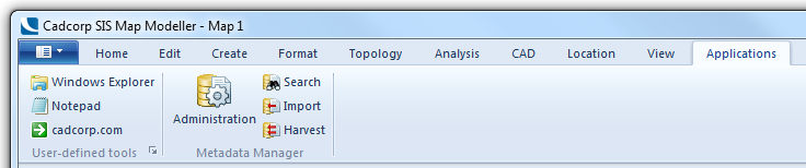
The Metadata Manager, once installed, is accessible through two locations:
The Metadata Manager provides the following general functionality:
There are two main functions covered by the Administration dialog; the ability to view all records in the metadata repository and manage duplicate or expired records through deletion and to re-configure connections to the GeognoSIS instance used as the metadata repository.
The user can quickly and easily search the metadata repository to see if any datasets they need are currently available. The user can enter a word which is then searched for within the keyword field of the metadata records. Because searching is performed on this field, it is important to ensure that appropriate keywords are used to facilitate meaningful searches.
The Metadata Manager provides the Overlay Specific Search by Title and Keyword function.
The Import command allows the user to read a Gemini metadata (.xml) file to create a new record in the metadata repository. This command is commonly used to import existing metadata supplied with data which the user has to then add to their own metadata repository. Using this command in the overlay context, the imported Gemini file metadata record is automatically linked to the overlay and database table from where the command is run.
Using this command from the Applications tab, the imported Gemini record is not linked to any database table. You can manage this record and export the metadata using the Administration dialog.
A harvest of metadata is the process of collecting as much metadata as possible from a single defined database. The harvest allows the user to target a database of existing spatial data and to do the following:
A harvest operation should only be carried out to initially populate a new metadata repository. It is a quick and easy way of establishing your initial metadata repository with a selected set of database tables.
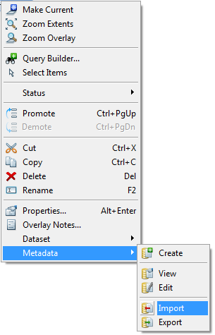
This command is used to create a new metadata record in the metadata repository for the current database overlay. This is a context sensitive command that relates entirely to the overlay from which the command is run. Using the right mouse button on the overlay name in the Map Control Bar will create a metadata record for the overlay, automatically populating the following fields:
To view the metadata for any overlay, use this context sensitive option. Using the View option from the required overlay will open the full metadata record for that overlay. In View mode, the user cannot edit the metadata.
To edit the metadata for any overlay, use this context sensitive option. Using the Edit option from the required overlay will open the full metadata record for that overlay. In Edit mode, the user can edit the metadata.
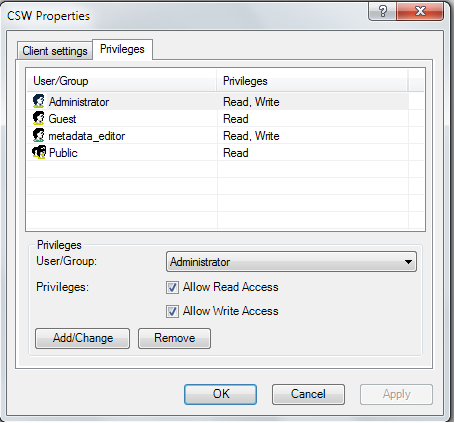
The GeognoSIS Administrator can control which users have access to edit the metadata repository by setting Windows Security on the GeognoSIS CS-W instance. This is set using the Privileges tab in GeognoSIS Manager. Until any Privileges are set on the CS-W instance, all users will have read and write access.
To export the metadata record to the Gemini 2.1 format, use the Export command. The metadata record for the overlay from where the command was run will be exported to the Gemini 2.1 format by running this command. The Gemini 2.1 file is created to the specification required for UK Location and INSPIRE compliance. The export is checked for completeness using the Schematron Schema and will alert the user to the fields where the errors or omissions exist. Any incomplete metadata records will not be exported to Gemini 2.1 files.
Write access to the GeognoSIS CS-W instance is required for the following commands:
Information on creating GeognoSIS users and setting their privileges can be found in the GeognoSIS help (Cadcorp GeognoSIS Manager > Machines > localhost > GeognoSIS > Local menu > GeognoSIS Properties - Authentication) and (Cadcorp GeognoSIS Manager > Machines > localhost > GeognoSIS > Users > Local menu).
Click to return to www.cadcorp.com
© Copyright 2000-2017 Computer Aided Development Corporation Limited (Cadcorp).