.gif) Viewshed Viewshed
Viewshed Viewshed Viewshed calculates a 'viewshed' over Grid Items.
A Viewshed is the area that can be seen from a particular 3D location. For example, you could calculate a viewshed to determine how many residents in an area would be able to see a proposed wind generator. SIS can calculate viewsheds for Digital Terrain Models (DTM) or grid items.
To create a viewshed:
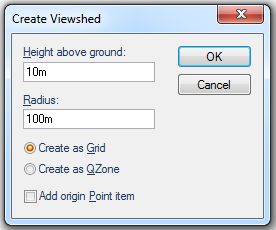
Height above ground
The height above the snapped point from which to calculate the Viewshed.
Radius
The radius of the viewshed.
Create as Grid
The result of the Viewshed calculation will be one Grid item for each of the source Grid items.
Create as QZone
The result of the Viewshed calculation will be a single QZone item.
Add origin Point item
Check the tickbox to create a Point item at the origin of the Viewshed.
Top of page
Send comments on this topic.
Click to return to www.cadcorp.com
© Copyright 2000-2017 Computer Aided Development Corporation Limited (Cadcorp).